

Adina Sommer
Antique and Contemporary Art
Winzerer Str. 154
80797 München
telephone
+49 89 304714
business hours:
by appointment
Email
![]()


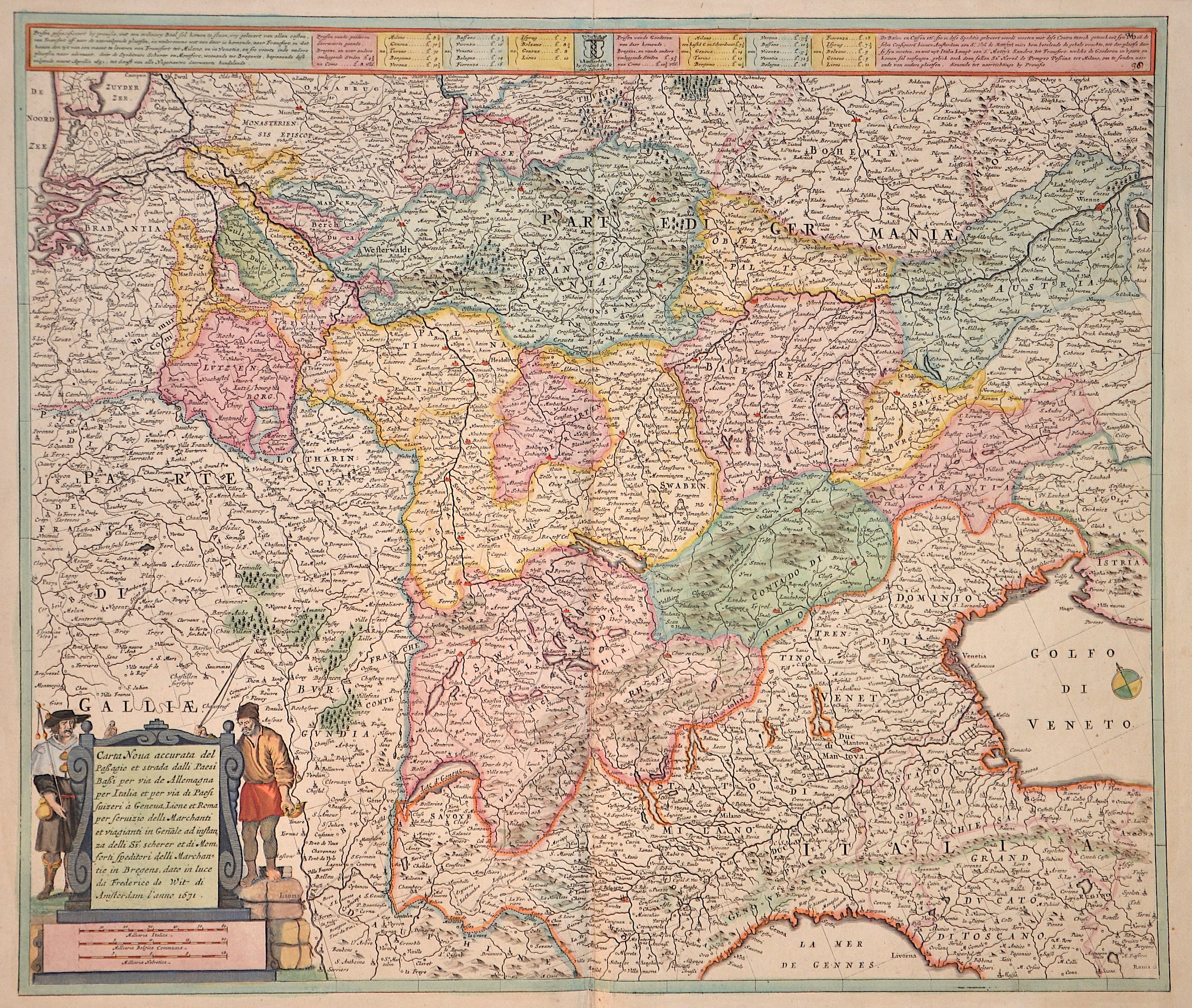
Carta noua accurata del Passagio et strada dalli Paesi Bassi per via Allemagna per Italia et per via di Paesi Suizeri a Geneua, Lione et Roma per….

| Article ID | EUX1941 |
Title | Carta noua accurata del Passagio et strada dalli Paesi Bassi per via Allemagna per Italia et per via di Paesi Suizeri a Geneua, Lione et Roma per…. |
Description | Map shows southern Germany with cockroaches, Bavaria, Switzerland, South Tyrol, Luxembourg and partly Austria. It also shows a title cartouche with a mileage indicator and an index above. |
| Year | dated 1671 |
Artist | Wit, de (1610-1698) |
Frederik de Wit (1610 – 1698). His Atlas began to appear around 1662 and by 1671 included anywhere from 17 to 151 maps each. In the 1690s he began to use a new title page "Atlas Maior" but continued to use his old title page. His atlas of the Low Countries first published in 1667,was named Nieuw Kaertboeck van de XVII Nederlandse Provinciën and contained 14 to 25 maps. Frederik de Wit quickly expanded upon his first small folio atlas which contained mostly maps printed from plates that he had acquired, to an atlas with 27 maps engraved by or for him. By 1671 he was publishing a large folio atlas with as many as 100 maps. Smaller atlases of 17 or 27 or 51 maps could still be purchased and by the mid-1670s an atlas of as many as 151 maps and charts could be purchased from his shop. In ca.1675 Frederik de Wit released a new nautical atlas. The charts in this atlas replaced the earlier charts from 1664 that are known today in only four bound examples and a few loose copies. Frederik de Wit new charts were sold in a chart book and as part of his atlases. Frederik de Wit published no fewer than 158 land maps and 43 charts on separate folio sheets. In 1695 Frederik de Wit began to publish a town atlas of the Netherlands after he acquired a large number of city plans at the auction of the famous Blaeu publishing firm’s printing plates. Dating Frederik de Wit atlases is considered difficult because usually no dates were recorded on the maps and their dates of publication extended over many years. | |
Historical Description | The concept of Germany as a distinct region in central Europe can be traced to Roman commander Julius Caesar, who referred to the unconquered area east of the Rhine as Germania, thus distinguishing it from Gaul (France), which he had conquered. In the High Middle Ages, the regional dukes, princes and bishops gained power at the expense of the emperors. Martin Luther led the Protestant Reformationagainst the Catholic Church after 1517, as the northern states became Protestant, while the southern states remained Catholic. The two parts of the Holy Roman Empire clashed in the Thirty Years' War (1618–1648). 1648 marked the effective end of the Holy Roman Empire and the beginning of the modern nation-state system, with Germany divided into numerous independent states, such as Prussia, Bavaria and Saxony. |
| Place of Publication | Amsterdam |
| Dimensions (cm) | 47,5 x 56 |
| Condition | Some restoration at lower centerfold |
| Coloring | original colored |
| Technique | Copper print |