

Adina Sommer
Antique and Contemporary Art
Winzerer Str. 154
80797 München
telephone
+49 89 304714
business hours:
by appointment
Email
![]()


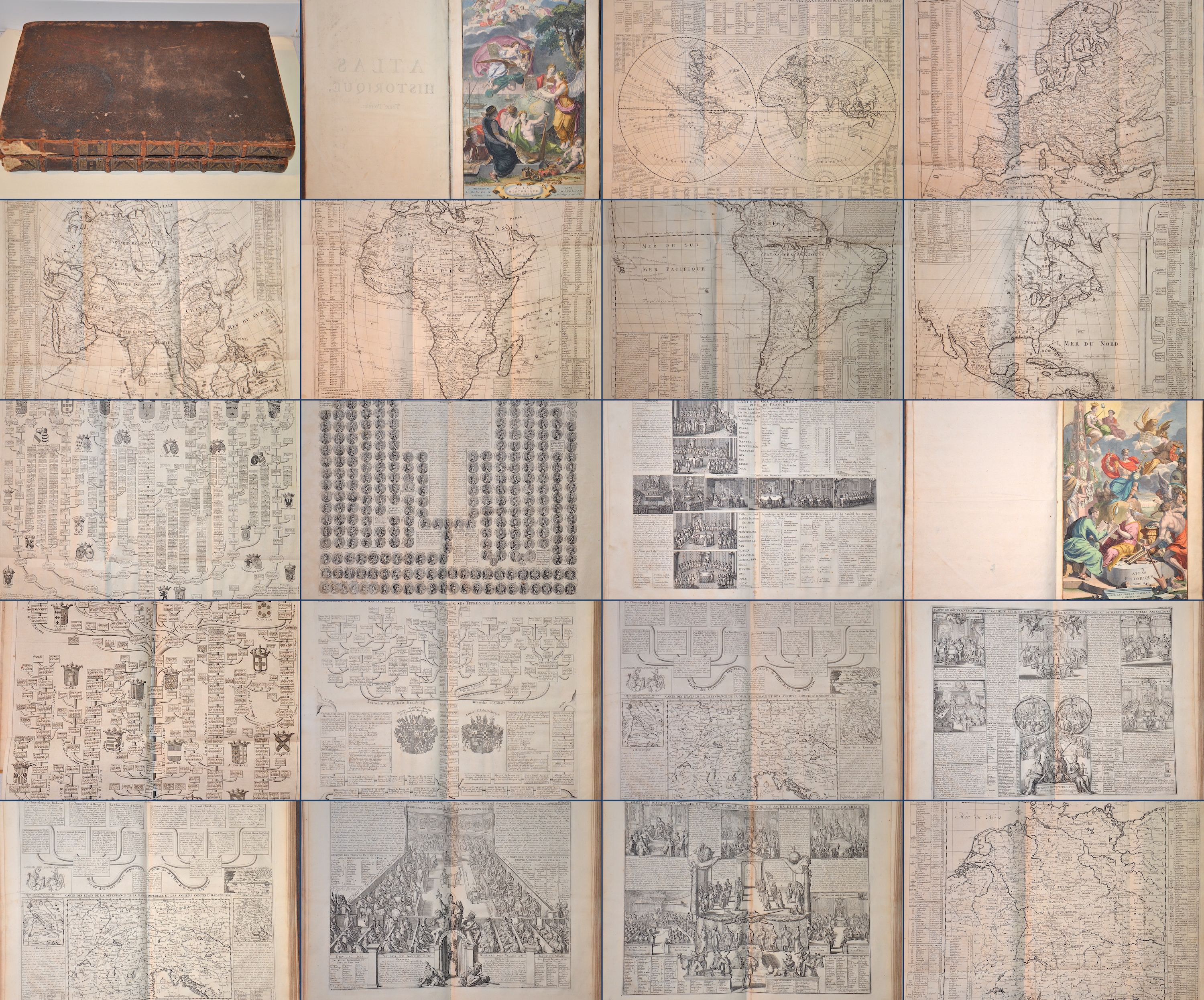
Atlas Historique, Tome Premier / Atlas Historque Tome II.

| Article ID | B0295 |
Title | Atlas Historique, Tome Premier / Atlas Historque Tome II. |
Description | Two atlases Historique, Tome I and Tome II published by L'Honore and Chatelain, Amsterdam 1720 and 1721, with notes on the history of each state, by Mr Gueudeville. Atlant Tome I with 82 pages of text and 47 plates (plates 41 and 46 are missing) including 12 folding maps such as the whole world, Europe, Asia, Africa, South America, North America, Spain and many family trees of European countries. On double pages are e.g. a plan of Rome, the ancient world, Greece, world with two hemispheres, a map of the sky and much more. Atlant Tome II with 90 text pages and 41 plates including 9 folding maps with family trees of Brandenburg, Nassau, Saxony, the Austrian royal house and maps of Bohemia, Hungary, Germany, etc. Both atlases open with splendidly coloured title pages. |
| Year | c. 1720 |
Artist | Chatelain (1684-1743) |
Henri Abraham Chatelain (1684 - 1743) was a Huguenot pastor of Parisian origins. He lived consecutively in Paris, St. Martins, London (c. 1710), The Hague (c. 1721) and Amsterdam (c. 1728). He is best known as a Dutch cartographer and more specifically for his cartographic contribution in the seminal seven volume Atlas Historique, published in Amsterdam between 1705 and 1720. Innovative for its time, the Atlas Historique combined fine engraving and artwork with scholarly studies of geography, history, ethnology, heraldry, and cosmography. Some scholarship suggests that the Atlas Historique was not exclusively compiled by Henri Chatelain, as is commonly believed, but rather was a family enterprise involving Henri, his father Zacharie and his brother, also Zacharie. | |
Historical Description | The term Atlas goes back to Gerhard Mercator and his work Atlas sive Cosmographicae Meditationes de Fabrica Mundi et Fabricati Figura, published posthumously in 1595 ("Atlas or cosmographic considerations about the creation of the world and the form of it"). In the foreword, Mercator explains the naming of his work in relation to the mythical King Atlas of Mauritania, who appears to Diodorus Siculus as a wise connoisseur of the stars and their spherical shape. Atlas of Mauritania belongs to the legendary circle around the Titan Atlas. As early as 100 AD, Marinus von Tyrus introduced the grad network card. Around 50 years later, Claudius Ptolemy made a kind of atlas. The beginning of the great voyages of discovery heralded a new development in cartography. Until the 15th century, maps were based on the classic works of Ptolemy (2nd century AD) and atlases, any collection of linked maps. The first atlas, in the sense of a book that was published in a specific edition with cards of the same format that were specially designed or produced for this edition, was Theatrum Orbis Terrarum (i.e. world stage) by Abraham Ortelius (1527–1598) , 1570 appeared in Antwerp, a tome with 70 current maps, which were coordinated in terms of content. 41 editions are known, which were published in different languages until 1612. Such an atlas was that of Gerhard and Cornelis de Jode: Speculum Orbis Terrarum. The first to use Atlas as a title for a similar work was Gerhard Mercator (1512–1594, still known from the projection of the same name, 1569), who was born in Rupelmonde in Flanders and who wrote the atlas published shortly after his death, sive Cosmographicae Meditationes de Fabrica Mundi and Fabricati Figura. France: The golden age is called the heyday of the 17th century in Holland. But the end of this era was also the end of the leading position of the Dutch in the field of Atlas cartography. Atlases were reissued, but not kept up to date. The dominance was taken over by France, which was then predominant in science and art. Already in 1652 Nicolas Sanson (1600–1667) and Pierre Mariette (1603–1657) published an atlas, which in 1658 was followed by the Cartes générales de toutes les parties du monde (Paris, 1658, with 113 cards, six more editions until 1676) which the Dutch atlases surpassed in reliability and timeliness. Triangulation has greatly improved the accuracy of the maps. A first example of this is the atlases by Nicolas de Fer (1646-1720), who wrote his Atlas curieux ou le monde dressé (Paris, 1699, 2 vols with 295 panels), based on the latest survey data from the French Académie des sciences and these Also had data checked by astronomers. The Atlas Nouveau by Guillaume Delisle (1675–1726), which appeared in Amsterdam in 1730, had 56 cards; in later editions extended to 138. Delisle maintained relationships with scholars and authorities around the world (including the Russian Tsar Peter the Great) with the intention of acquiring original templates for his cards. The famous cartographer Jean-Baptiste Bourguignon d’Anville (1697–1782) not only used up-to-date geodetic data, but also, after a critical examination, reports from explorers. His Atlas Général (1780, 46 sheets) is known. Rigobert Bonne (1727–1794), who is still famous due to the map projection named after him, made a name for himself with the Atlas modern ou collection de cartes sur toutes les parties du globe terrestre (Paris, 1771) and with Nicolas Desmarest (1725–1815) wrote a three-volume atlas for the new edition (Paris, 1787/88) published by Panckouke of the famous Encyclopédie by Diderot and d'Alembert. England: The most famous 18th century English atlases were New and Compleat Atlas (1720, 27 maps) by Herman Moll, New General Atlas (1721, 48 plates) by Senex, General Atlas (1770) and New Universal Atlas (1790) by Kitchin, General Atlas of the four grand quarters of the World (1778, later General Atlas of the World) von Faden, u. a. However, they cannot be compared to the French atlases in the same period. Germany:World map from the Atlas portatilis (1717–1780) by Melissantes and Johann Christoph Weigel. The scientific value of the atlases that appeared in Germany in the 18th century was limited. The best-known cartographer and publisher was Johann Baptist Homann (1664–1724) from Nuremberg, who published several large atlases, such as the Great Atlas of the Whole World (1716, 126 maps). His heirs expanded the publishing house with a 3-volume Atlas geographicus maior (1740), which also contained works by others. A student of Homann, Mattias Seutter (1678–1756) from Augsburg published various atlases, for example an Atlas Geographicus (1720) with 46 maps, which was published several times. In general, however, Seutter's works are not very original and mostly reproductions. The small two-part ATLAS PORTATILIS by Johann Christoph Weigel (copperplate engraver) and Johann Gottfried Gregorii alias MELISSANTES (text author) underwent several editions between 1717/1723 and 1780. The second part, called Continuirter ATLAS PORTATILIS GERMANICUS, was somewhat accurate due to the partial use of the good templates by Adam Friedrich Zürner, which also explains the decades of use of these handy pocket and school atlases. Austria: It was only in Austria at the end of the 18th century that there was talk of its own Atlas culture. The best-known works are Schrämbl's General Great Atlas (Vienna, 1786 and later, 133 maps) and probably the most name-rich Atlas of all time, the scene of the five parts of the world, published by Franz Johann Joseph von Reilly (Vienna, 1789 and later) 830 plates that were not fully finished. |
| Place of Publication | Amsterdam |
| Dimensions (cm) | 45,5 x 29 cm |
| Condition | Binding in hardcover with leather embossed in gold, minor damage |
| Coloring | black/white |
| Technique | Copper print |