

Adina Sommer
Antique and Contemporary Art
Winzerer Str. 154
80797 München
telephone
+49 89 304714
business hours:
by appointment
Email
![]()


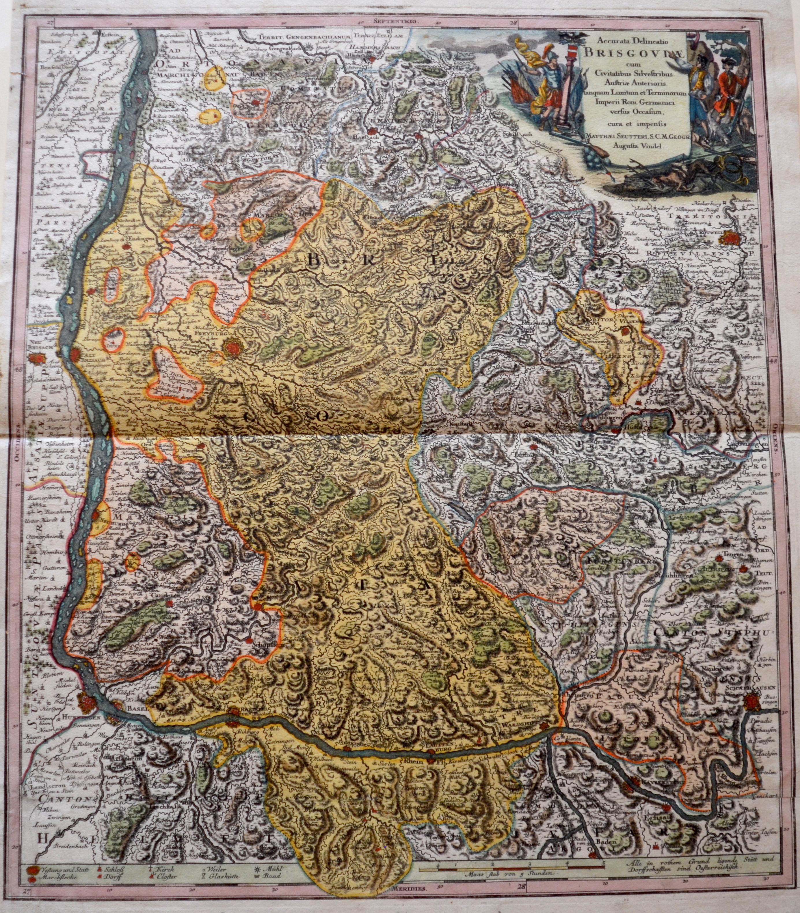
Accurata Delineatio Brisgoviae cum Civitatibus Silvestribus Austriae Anterioris,…

| Article ID | EUD4010 |
Title | Accurata Delineatio Brisgoviae cum Civitatibus Silvestribus Austriae Anterioris,… |
Description | Map shows the upper river Rhine with the Breisgau in the southwestern part of Baden-Wuertemberg. Showing the cities: Freiburg, Breisach am Rhein, Basel, Rheinfelden, Laufenburg, Schaffhausen, etc. with a magnificent cartouche. |
| Year | ca. 1730 |
Artist | Seutter (1678-1757) |
Matthias Seutter (1678- 1757) Augsburg was the son of a goldsmith in Augsburg. In 1697, Seutter began his studies in Nuremberg and subsequently worked in the publishing house of Jeremias Wolff in Augsburg. In 1710, he established his own publishing house and print shop. The Seutter publishing house produced a great number of maps, atlases, and globes. However, very few original maps were printed there, as Augsburg at that time had no university and no connection to the fields of mathematics or the natural sciences. Seutter therefore copied the work of other cartographers, making his own engravings based on their models. Over 500 maps were produced in his studio. Seutter's most well-known works are the 1725 "Geographical Atlas or an Accurate Depiction of the Whole World" ("Atlas Geographicus oder Accurate Vorstellung der ganzen Welt") with 46 maps, the 1734 "Large Atlas" ("Grosser Atlas") with 131 maps, and the 1744 pocket atlas "Small Atlas" ("Atlas minor") with 64 maps. Matthäus Seutter died in 1757. Seutter's son Albrecht Karl, his son-in-law Conrad Tobias Lotter, and his business partner Johann Michael Probst ran the printing business for five more years. | |
Historical Description | Baden-Wuertemberg is a state in southwest Germany, east of the Rhine, which forms the border with France. It is is formed from the historical territories of Baden, Prussian Hohenzollern, and Württemberg, and also parts of Swabia. Baden Würtemberg was only founded in 1952 by the merger of the states of Württemberg-Baden, Baden and Württemberg-Hohenzollern. Today the most populous city of Baden-Württemberg is the state capital Stuttgart, followed by Karlsruhe and Mannheim. Other major cities are Freiburg im Breisgau, Heidelberg, Ulm, Heilbronn, Pforzheim and Reutlingen. The early modern period was marked by the Reformation and the expansion efforts of the emerging states of Austria, Prussia, France and Sweden. Conflicts such as the Peasant War, the Thirty Years' War and the Palatinate War of Succession resulted from these. One of the focal points of the fighting, with corresponding consequences for the population and the economy, was in what is today Baden-Württemberg, which remained extremely fragmented territorially. At the beginning of the 19th century, around 300 states still had territorial rights in what is now Baden-Württemberg, but their number was reduced to four after the dissolution of the Old Empire. The Kingdom of Württemberg and the Grand Duchy of Baden were among the winners of the coalition wars. The two principalities of Hohenzollern-Sigmaringen and Hohenzollern-Hechingen survived mediatization due to their special relationship with Napoléon. In 1849, the Baden Revolution was put down by Prussian intervention forces, the Baden army was dissolved and rebuilt under Prussian leadership. In 1850 the two Hohenzollern states became the Prussian province of Hohenzollernsche Lande. With the new formation of the tribal duchies, the southern areas of what is now the state of Baden-Württemberg belonged to the Duchy of Swabia until the end of the High Middle Ages, the northern areas were located with the Duchy of Franconia. |
| Place of Publication | Augsburg |
| Dimensions (cm) | 57 x 49,5 |
| Condition | Some folds smoothed |
| Coloring | original colored |
| Technique | Copper print |