

Adina Sommer
Antique and Contemporary Art
Winzerer Str. 154
80797 München
telephone
+49 89 304714
business hours:
by appointment
Email
![]()


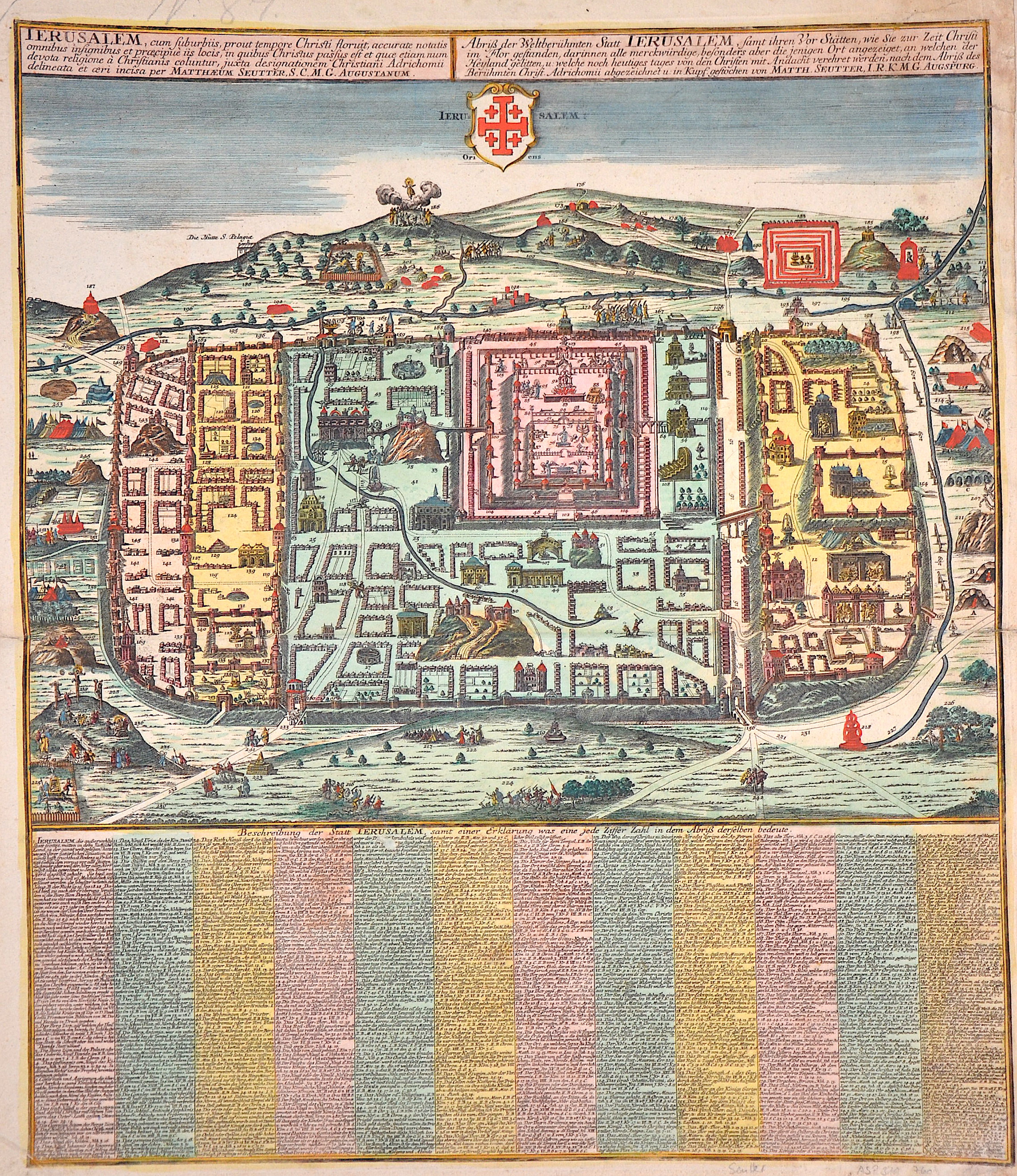
Abriss der Weltberühmten Statt Jerusalem, samt ihren Vor Stätten wie sie zur Zeit Christi im Flor gestanden, ..

| Article ID | ASP319 |
Title | Abriss der Weltberühmten Statt Jerusalem, samt ihren Vor Stätten wie sie zur Zeit Christi im Flor gestanden, .. |
Description | Map shows the magnificent city plan of Jerusalem with its coat of arms. Below is an index with a description of the individual buildings. |
| Year | ca. 1730 |
Artist | Seutter (1678-1757) |
Matthias Seutter (1678- 1757) Augsburg was the son of a goldsmith in Augsburg. In 1697, Seutter began his studies in Nuremberg and subsequently worked in the publishing house of Jeremias Wolff in Augsburg. In 1710, he established his own publishing house and print shop. The Seutter publishing house produced a great number of maps, atlases, and globes. However, very few original maps were printed there, as Augsburg at that time had no university and no connection to the fields of mathematics or the natural sciences. Seutter therefore copied the work of other cartographers, making his own engravings based on their models. Over 500 maps were produced in his studio. Seutter's most well-known works are the 1725 "Geographical Atlas or an Accurate Depiction of the Whole World" ("Atlas Geographicus oder Accurate Vorstellung der ganzen Welt") with 46 maps, the 1734 "Large Atlas" ("Grosser Atlas") with 131 maps, and the 1744 pocket atlas "Small Atlas" ("Atlas minor") with 64 maps. Matthäus Seutter died in 1757. Seutter's son Albrecht Karl, his son-in-law Conrad Tobias Lotter, and his business partner Johann Michael Probst ran the printing business for five more years. | |
Historical Description | One of the oldest cities in the world, Jerusalem was named as "Urusalima" on ancient Mesopotamian cuneiform tablets, probably meaning "City of Shalem". During its long history, Jerusalem has been destroyed at least twice. The part of Jerusalem called the City of David was settled in the 4th millennium BCEIn 1538, walls were built around Jerusalem under Suleiman the Magnificent. Today those walls define the Old City, which has been traditionally divided into four quarter. There is no evidence of a permanent settlement in the City of David area until the early Bronze Age . Many Jewish tombs from the Second Temple period have been rediscovered in Jerusalem. One example, discovered north of the Old City, contains human remains in an ossuary decorated with the Aramaic inscription "Simon the Temple Builder. In 1517, Jerusalem and environs fell to the Ottoman Turks, who generally remained in control until 1917 .Jerusalem enjoyed a prosperous period of renewal and peace under Suleiman the Magnificent – including the rebuilding of magnificent walls around the Old City. Throughout much of Ottoman rule, Jerusalem remained a provincial, if religiously important center, and did not straddle the main trade route between Damascus and Cairo. The English reference book Modern history or the present state of all nations, written in 1744, stated that "Jerusalem is still reckoned the capital city of Palestine, though much fallen from its ancient grandeaur". The Ottomans brought many innovations: modern postal systems run by the various consulates and regular stagecoach and carriage services were among the first signs of modernization in the city. In the mid 19th century, the Ottomans constructed the first paved road from Jaffa to Jerusalem, and by 1892 the railroad had reached the city. |
| Place of Publication | Augsburg |
| Dimensions (cm) | 57 x 49,7 cm |
| Condition | Some folds and corner at the bottom right professionally restored. |
| Coloring | original colored |
| Technique | Copper print |