

Adina Sommer
Antique and Contemporary Art
Winzerer Str. 154
80797 München
telephone
+49 89 304714
business hours:
by appointment
Email
![]()


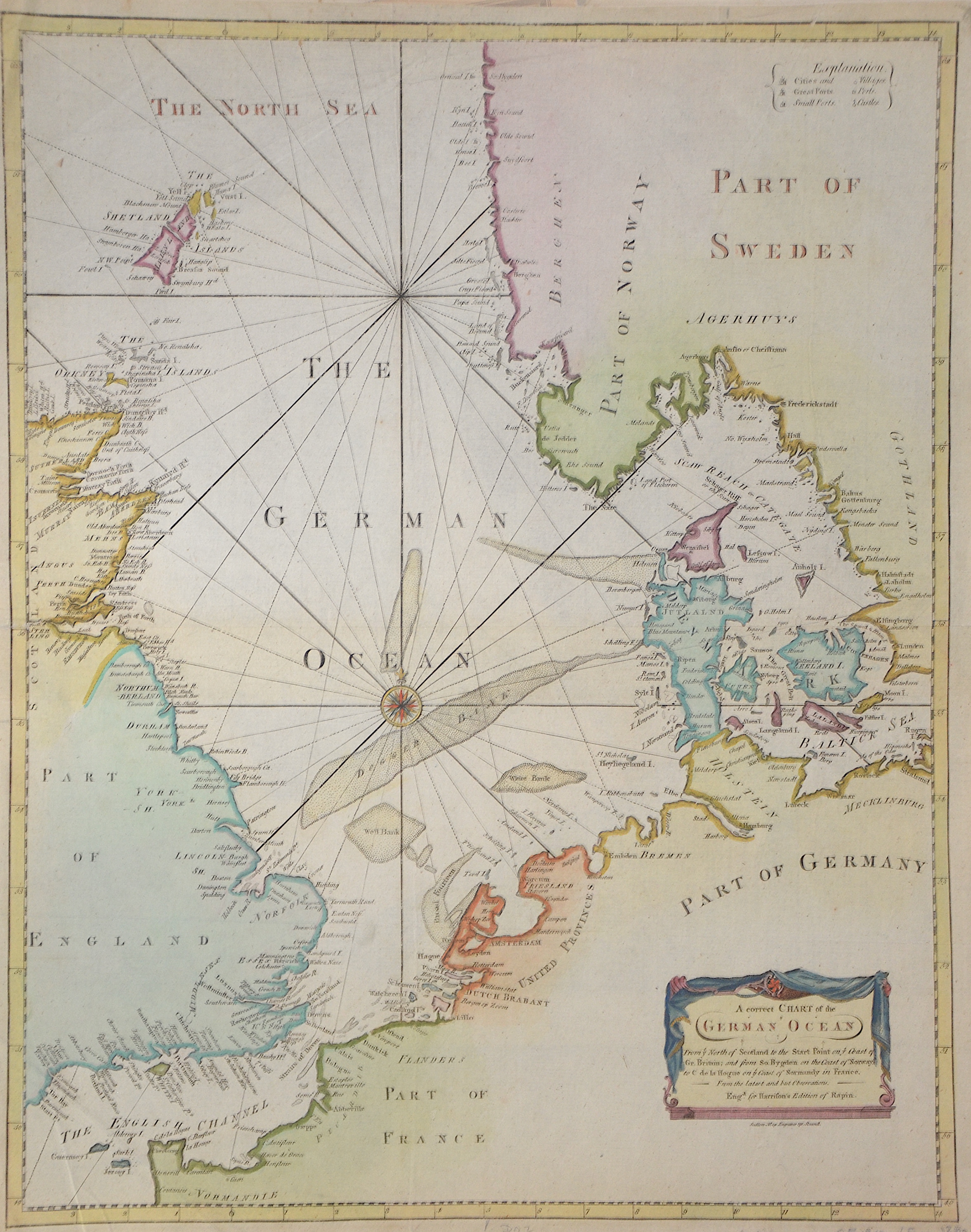
A correct Chart of the German Ocean

| Article ID | SE0318 |
Title | A correct Chart of the German Ocean |
Description | Copper engraved map of the North Sea and the English Channel from the Channel Islands in the south to the Shetland Islands in the north with the east coast of Great Britain, Denmark, partly Norway, Sweden, France, the Netherlands, Germany and a title cartouche. Produced for Harrison's Edition of Rapin's. |
| Year | ca. 1720 |
Artist | Rapin de Thoyras (1661-1725) |
Paul de Rapin de Thoyras ( 1661 – 1725), sieur of Thoyras (and therefore styled Thoyras de Rapin), was a French historian writing under English patronage. The son of Jacques de Rapin, an avocat at Castres (Tarn), he was educated at the Protestant Academy of Saumur, and in 1679 became an advocate, but soon afterwards joined the army. The revocation of the Edict of Nantes in 1685, and the death of his father led him to move to England; but, unable to find work there, he went on to the Netherlands where he enlisted in a company of French volunteers at Utrecht, commanded by his cousin, Daniel de Rapin. He accompanied William III to England in 1688, and during the Williamite war in Ireland he took part in the Siege of Carrickfergus and the Battle of the Boyne, and was wounded at the Siege of Limerick (1690). Soon afterwards he was promoted to captain; but in 1693 he resigned in order to become tutor to the Earl of Portland's son. After travelling with the boy, he settled with his family (he married Marie-Anne Testart in 1699) in Holland, first at the Hague, then,at Wesel, in 1707. | |
Historical Description | The North Sea is a marginal sea of the Atlantic Ocean. It is a shelf sea and is located in north-western Europe. Except for the straits near the English Channel and the Skagerrak, it is bordered by land on three sides and opens up in a funnel shape to the north-eastern Atlantic. The North Sea itself is an important trade route and serves as Central and Northern Europe's access to world markets. Together with the adjacent English Channel, the southern North Sea is the world's busiest shipping region. |
| Dimensions (cm) | 47 x 37 cm |
| Condition | Some folds |
| Coloring | colored |
| Technique | Copper print |
Reproduction:
45.00 €
( A reproduction can be ordered individually on request. )