

Adina Sommer
Antique and Contemporary Art
Winzerer Str. 154
80797 München
telephone
+49 89 304714
business hours:
by appointment
Email
![]()


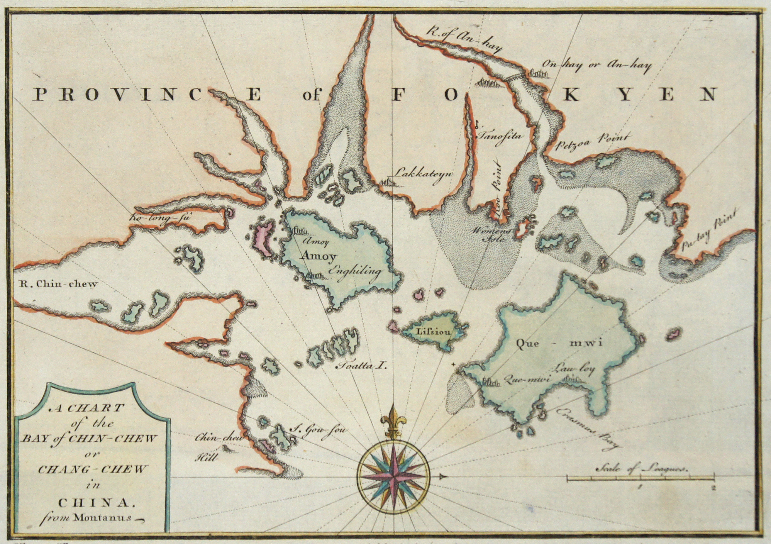
A Chart of the Bay of Chin-Chew or Chang-Chew in China.

| Article ID | ASC1145 |
Title | A Chart of the Bay of Chin-Chew or Chang-Chew in China. |
Description | Detailed map of the Bay of Zhangzhou in the Province Fujian. The map focuses on the city of Amoy (here spelled Emowi), or modern day Xiamen. Being primarily a nautical chart, the map offers limited inland detail, but the city of Amoy (Xiamen), as well as adjacent points of interest including fortifications, palaces, pagodas, and nearby cities, are rendered pictorially. On the island itself a large mountain, most likely Xianyue Mountain, with a tower, is depicted. Xiamen or Amoy was a place of exceptional interest to European traders as China's main port for the export of tea. |
| Year | ca. 1660 |
Artist | Montanus (1625-1683) |
Arnold Montanus (1625-1683) was a Dutch theologian and historian. In addition to extensive editorial work, he has written numerous historical treatises dealing with the peoples and culture of the New World and the overseas activities of the Dutch. Although he never left Europe himself, his books, translated into many languages, had a great influence on the European perception of the area concerned. De Nieuwe en Onbekende Weereld (The Unknown New World) and Gedenkwardige Gesantschappen der Oost-Indische Maatschappy in′t Vereenigde Nederland (Memorable Embassies of the East Indian Society in the United Netherlands) are his best known writings. He published Guiccardini's description of the Netherlands in Dutch in 1612, translated Giovanni Gioviano Pontano's (Pontanus) description of the trading city of Amsterdam from Latin in 1614, and published Mercator's Cosmographicae Meditationes in 1621. The additions to the text in Hondius' edition of Mercator's great atlas are probably also from his pen. Montanus bought seafarers and employees of the Dutch East India Company (Vereenigde Oostindische Compagnie, VOC) information and travel reports, and published them in 1669 in the publishing house of Jacob van Meurs (1619–1680). | |
Historical Description | By the 15th century, Beijing had essentially taken its current shape. The Ming city wall continued to serve until modern times, when it was pulled down and the 2nd Ring Road was built in its place. It is generally believed that Beijing was the largest city in the world for most of the 15th, 16th, 17th, and 18th centuries.The first known church was constructed by Catholics in 1652 at the former site of Matteo Ricci's chapel; the modern Nantang Cathedral was later built upon the same site. The capture of Beijing by Li Zicheng's peasant army in 1644 ended the dynasty, but he and his Shun court abandoned the city without a fight when the Manchu army of Prince Dorgon arrived 40 days later. The Forbidden City was the Chinese imperial palace from the Ming dynasty to the end of the Qing dynasty( the years 1420 to 1912). It is located in the center of Beijing, China, and now houses the Palace Museum. When Hongwu Emperor's son Zhu Di became the Yongle Emperor, he moved the capital from Nanjing to Beijing, and construction began in 1406 on what would become the Forbidden City. Construction lasted 14 years and required more than a million workers. It served as the home of emperors and their households as well as the ceremonial and political center of Chinese government for almost 500 years. The palace complex exemplifies traditional Chinese palatial architecture, and has influenced cultural and architectural developments in East Asia and elsewhere. Since 1925 the Forbidden City has been under the charge of the Palace Museum, whose extensive collection of artwork and artifacts were built upon the imperial collections of the Ming and Qing dynasties. |
| Place of Publication | Amsterdam |
| Dimensions (cm) | 14,5 x 20,5 |
| Condition | Very good |
| Coloring | colored |
| Technique | Copper print |