

Adina Sommer
Antique and Contemporary Art
Winzerer Str. 154
80797 München
telephone
+49 89 304714
business hours:
by appointment
Email
![]()


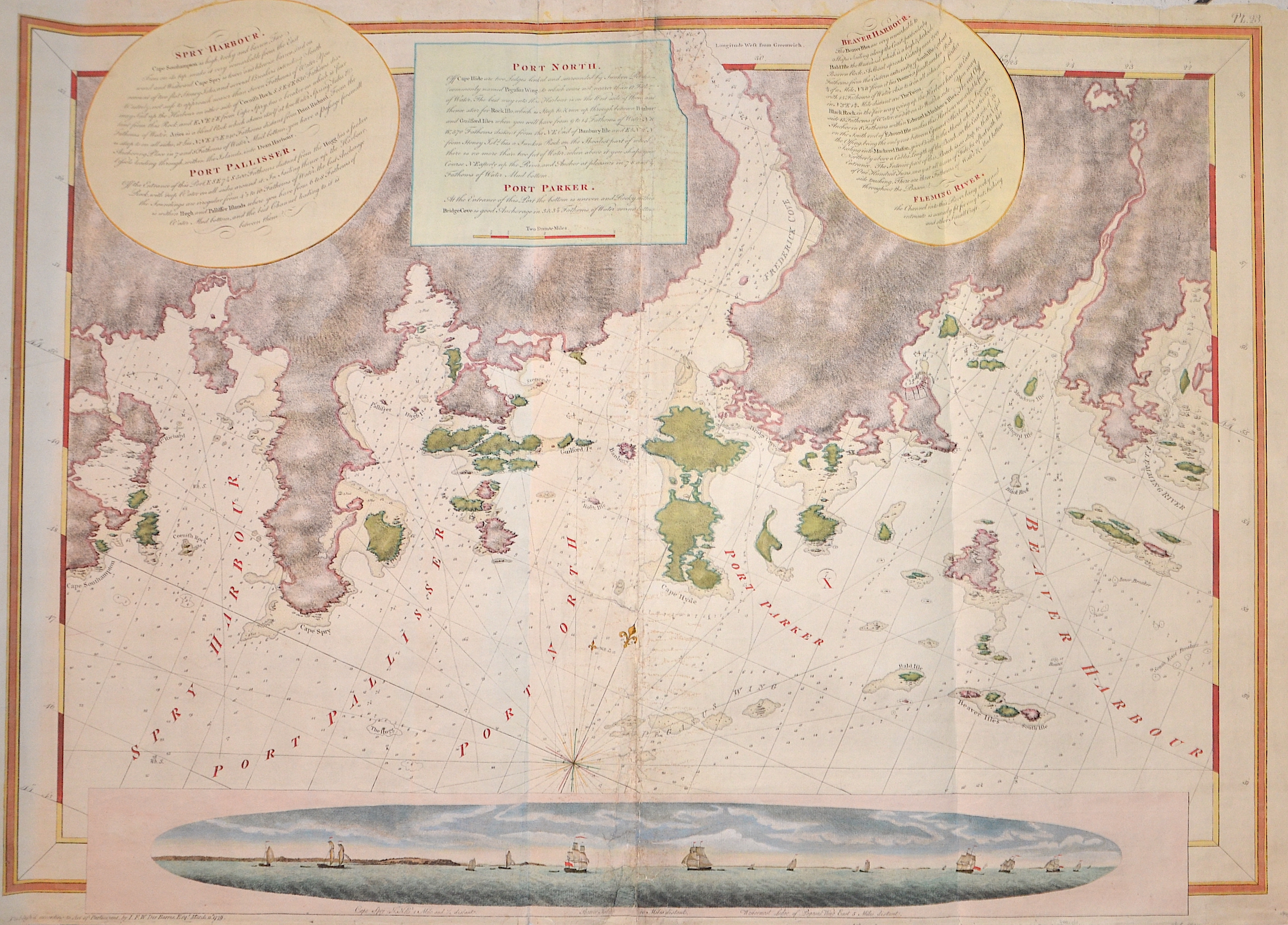
Spry Harbour/ Post Pallisser/ Post North/ Post Parker/ Beaver Harbour/ Fleming River

| Article ID | AMC0824 |
Title | Spry Harbour/ Post Pallisser/ Post North/ Post Parker/ Beaver Harbour/ Fleming River |
Description | Map shows the east coasts of Canada with Beaver Harbour, Fleming River, Mushaboom Harbour, Nova Scotia, Port North, Port Pallisser , Port Parker , Quoddy Inlet,Sheet Harbour,Spry Harbour.Lower part of the map a view of Cape Spry with offshore ships. |
| Year | dated 1779 |
Artist | Des Barres (1721-1824) |
Joseph Frederick Wallet Des Barres was unquestionably one of the most important and talented map makers of the day. He personally surveyed many hundreds of miles of the coastlines of the North American continent. He spent two years surveying and charting the very remote Isle of Sable, an area which lay close to vital shipping lanes. The area was known at the time as 'one of America's most populated graveyard. DesBarres toiled for some years to produce his charts and views in a finished form. They were eventually incorporated in The Atlantic Neptune, a large collection of charts and views produced by DesBarres. The Neptune was published by him on behalf of the Admiralty, and appeared between 1774 and 1784. It consists of four series of charts covering Nova Scotia, New England, the Gulf of St Lawrence including Cape Breton and St John’s (Prince Edward) Island, and the coast south of New York, accompanied by “various views of the North American coast.” Although DesBarres was indebted to Holland and his assistants for many surveys, a fact which he acknowledged, his own contribution is not negligible. Moreover, it is in their artistic quality that the charts and views especially shine, since their accuracy is combined with an aesthetic character that places DesBarres among the more notable of the century’s minor artists. The Neptune does contain some inaccuracies, but these are probably accounted for by the fact that DesBarres had rushed production in response to the mounting pressure for publication, unrest in the Thirteen Colonies having created a demand for accurate naval charts. Nevertheless, DesBarres’s charts served as standard guides for navigation until the work of Henry Wolsey Bayfield and Peter Frederick Shortland well into the 19th century. While in Nova Scotia, DesBarres became convinced of the great potential of the Maritime colonies for settlement. He began to obtain land by grant or purchase, and eventually came to own property in the Tatamagouche region,. Falmouth Township, and Cumberland County in Nova Scotia, as well as tracts between the Memramcook and Petitcodiac rivers in present-day New Brunswick. These acquisitions, which made him one of the greatest landowners in the Maritime colonies, were procured relatively cheaply, partly because he was friendly with Nova Scotian officials. | |
Historical Description | Various indigenous peoples have inhabited what is now Canada for thousands of years before European colonization. Beginning in the 16th century, British and French expeditions explored and later settled along the Atlantic coast. As a consequence of various armed conflicts, France ceded nearly all of its colonies in North America in 1763. In 1867, with the union of three British North American colonies through Confederation, Canada was formed as a federal dominion of four provinces. In 1583, Sir Humphrey Gilbert, by the royal prerogative of Queen Elizabeth I, founded St. John's, Newfoundland, as the first North American English colony. French explorer Samuel de Champlain arrived in 1603 and established the first permanent European settlements at Port Royal (in 1605) and Quebec City (in 1608). Among the colonists of New France, Canadiensextensively settled the Saint Lawrence River valley and Acadians settled the present-day Maritimes, while fur traders and Catholic missionaries explored the Great Lakes, Hudson Bay, and the Mississippi watershed to Louisiana. The Beaver Wars broke out in the mid-17th century over control of the North American fur trade. The Royal Proclamation of 1763 established First Nation treaty rights, created the Province of Quebec out of New France, and annexed Cape Breton Island to Nova Scotia. After the successful American War of Independence, The 1783 Treaty of Paris recognized the independence of the newly formed United States and set the terms of peace, ceding British North American territories south of the Great Lakes to the new country. the Constitutional Act of 1791 divided the province of Canada into French-speaking Lower Canada (later Quebec) and English-speaking Upper Canada (later Ontario), granting each its own elected legislative assembly. |
| Dimensions (cm) | 71 x 98 cm |
| Condition | Centerfold and tears on upper margin perfetly restored |
| Coloring | original colored |
| Technique | Copper print |
Reproduction:
441.00 €
( A reproduction can be ordered individually on request. )