

Adina Sommer
Antique and Contemporary Art
Winzerer Str. 154
80797 München
telephone
+49 89 304714
business hours:
by appointment
Email
![]()


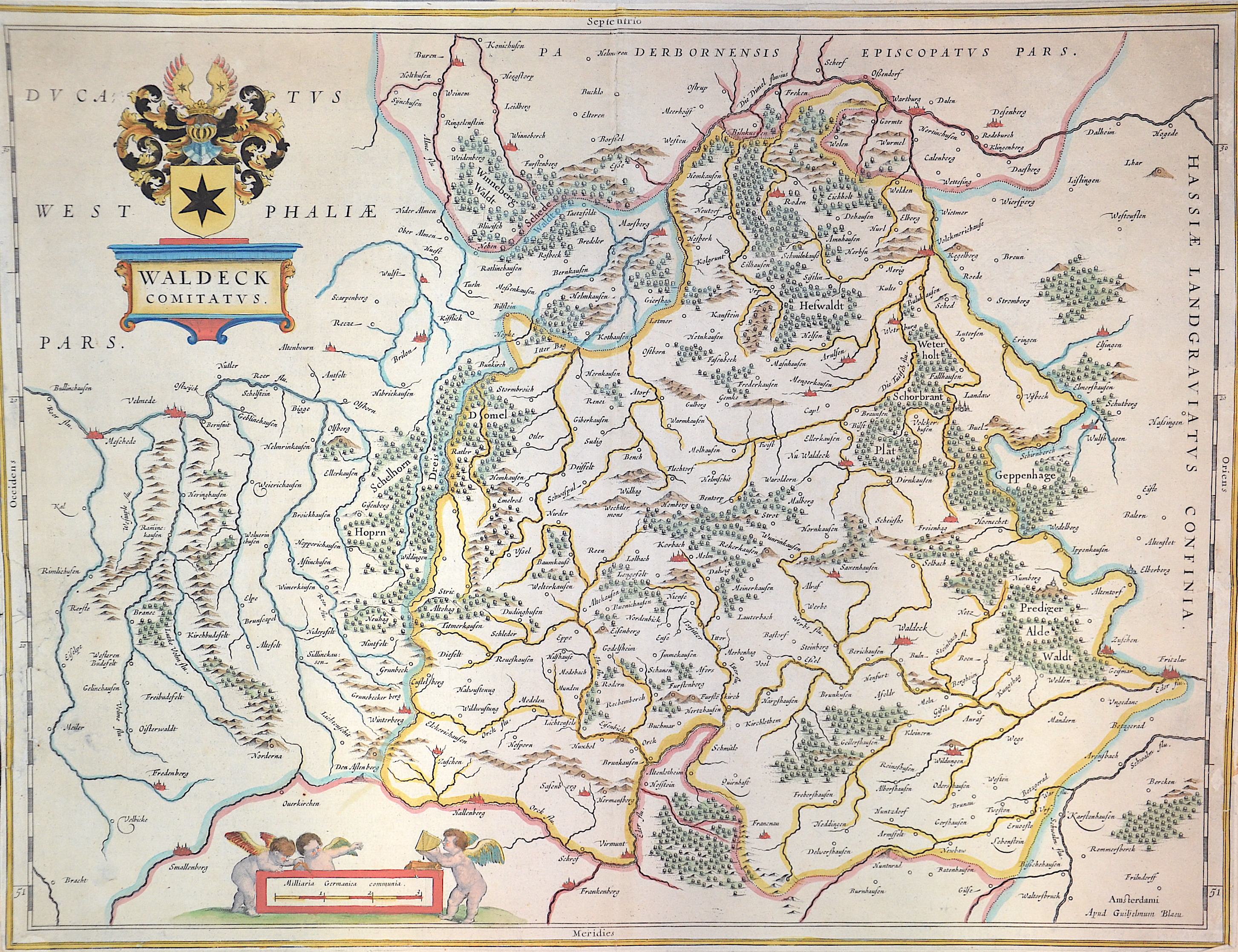
Waldeck Comitatus.

| Article ID | EUD0049 |
Title | Waldeck Comitatus. |
Description | Map shows the surroundings of Waldeck in Hesse with a mileage indicator cartouche and title cartouche with the coat of arms of Waldeck. |
| Year | ca. 1640 |
Artist | Blaeu (1571-1638) |
Joan Guilliemus Blaeu was the eldest son of Willem Janszoon Blaeu (1571-1638), and was probably born in Alkmaar in the province of Noord-Holland in the final years of the 16th century. He was brought up in Amsterdam, and studied law at the University of Leiden before going into partnership with his father in the 1630s. Although his father Willem had cartographic interests, having studied under the Danish astronomer Tycho Brahe and having manufactured globes and instruments, his primary business was as a printer. It was under the control of Joan that the Blaeu printing press achieved lasting fame by moving towards the printing of maps and expanding to become the largest printing press in Europe in the 17th century. By the 1660s the Theatrum Orbis Terrarum (or Atlas Maior as it had became known by this time) had expanded to between 9 and 12 volumes, depending on the language. With over 3,000 text pages and approximately 600 maps, it was the most expensive book money could buy in the later 17th century. The translation of the text from Latin into Dutch, English, German, French, and Spanish for several volumes created enormous work for those involved in typography and letterpress activities. It is estimated that over 80 men must have been employed full-time in the Blaeu printing house in Bloemgracht, not including engravers who worked elsewhere, with over 15 printing presses running simultaneously, and in 1667 a second press was acquired at Gravenstraat. At the same time as producing the Atlas Maior, Blaeu was also publishing town plans of Italy, maps for globes, and other volumes. At its peak the Blaeu press managed to produce over 1 million impressions from 1,000 copper plates within four years. | |
Historical Description | The history of Hesse in the 16th to 19th centuries was shaped by significant political, religious, and social changes. This period was marked by the Reformation, the Thirty Years' War, the Napoleonic Wars, and changes within the German Confederation. In the 16th century, Hesse was a state in the Holy Roman Empire. The Reformation began in Hesse in 1527, when Landgrave Philip the Magnanimous of Hesse became one of the first German princes to adopt the Lutheran faith. As a result, Hesse became a center of the Reformation, which brought profound religious and political changes to the region. In the 17th century, Hesse was affected by the Thirty Years' War (1618–1648). The war, which plunged Europe into a devastating conflict, also had catastrophic consequences for Hesse. In particular, the mid-century saw economic decline and social hardships. The Peace of Westphalia (1648) ended the war, but its economic and political repercussions were felt for a long time. In the 18th century, Hesse began to stabilize. The state was an important part of the Holy Roman Empire and was governed by the Landgraves of Hesse-Kassel. Hesse-Kassel was a prosperous region, particularly benefiting from tax revenues generated through trade in iron and salt. The early 19th century was shaped by the Napoleonic Wars and the resulting upheavals. In 1806, Hesse-Kassel joined the Confederation of the Rhine and came under French influence. After the end of the Napoleonic era and the decisions of the Congress of Vienna (1815), Hesse-Kassel came under the control of the House of Hesse again but became part of the German Confederation, a loose union of German states. In 1866, Hesse took part in the Austro-Prussian War and, after the conflict, was annexed by Prussia and integrated into the Prussian province of Hesse-Nassau. By the end of the 19th century, Hesse had become part of the newly unified German Empire, established in 1871 under Prussian leadership, and the region experienced a phase of industrialization and modernization. |
| Place of Publication | Amsterdam |
| Dimensions (cm) | 38 x 50 cm |
| Condition | Very good |
| Coloring | colored |
| Technique | Copper print |