

Adina Sommer
Antique and Contemporary Art
Winzerer Str. 154
80797 München
telephone
+49 89 304714
business hours:
by appointment
Email
![]()


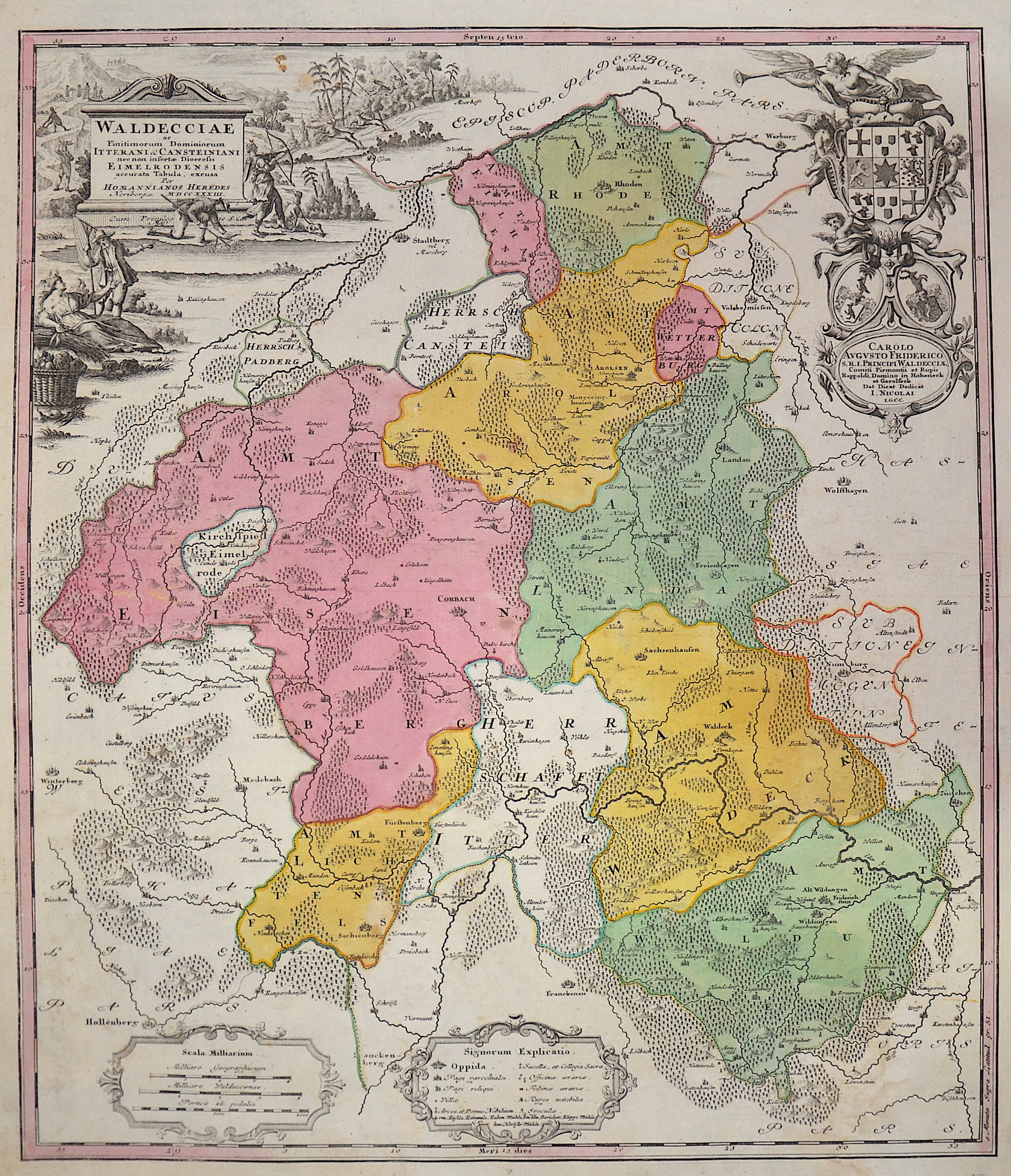
Waldecciae

| Article ID | EUD4647 |
Title | Waldecciae |
Description | Map shows Waldeck with Korbach, Bad Wildungen, Mengeringhausen and many more. Furthermore, four magnificent cartouches and heraldic representations. |
| Year | c. 1733 |
Artist | Homann Erben |
Johann Babtiste Homann (1664-1724) was born in Oberkammlach, the Electorate of Bavaria. Although educated at a Jesuit school, and preparing for an ecclesiastical career, he eventually converted to Protestantism and from 1687 worked as a civil law notary in Nuremberg. He soon turned to engraving and cartography; in 1702 he founded his own publishing house. Homann acquired renown as a leading German cartographer, and in 1715 was appointed Imperial Geographer by Emperor Charles VI. Giving such privileges to individuals was an added right that the Holy Roman Emperor enjoyed. In the same year he was also named a member of the Prussian Academy of Sciences in Berlin. Of particular significance to cartography were the imperial printing privileges (Latin: privilegia impressoria). These protected for a time the authors in all scientific fields such as printers, copper engravers, map makers and publishers. They were also very important as a recommendation for potential customers. In 1716 Homann published his masterpiece Grosser Atlas ueber die ganze Welt (Grand Atlas of all the World). Numerous maps were drawn up in cooperation with the engraver Christoph Weigel the Elder, who also published Siebmachers Wappenbuch. Homann died in Nuremberg. He was succeeded by the Homann heirs company, which was in business until 1848. The company was known as Homann Erben, Homanniani Heredes, or Heritiers de Homann abroad. | |
Historical Description | The history of Hesse in the 16th to 19th centuries was shaped by significant political, religious, and social changes. This period was marked by the Reformation, the Thirty Years' War, the Napoleonic Wars, and changes within the German Confederation. In the 16th century, Hesse was a state in the Holy Roman Empire. The Reformation began in Hesse in 1527, when Landgrave Philip the Magnanimous of Hesse became one of the first German princes to adopt the Lutheran faith. As a result, Hesse became a center of the Reformation, which brought profound religious and political changes to the region. In the 17th century, Hesse was affected by the Thirty Years' War (1618–1648). The war, which plunged Europe into a devastating conflict, also had catastrophic consequences for Hesse. In particular, the mid-century saw economic decline and social hardships. The Peace of Westphalia (1648) ended the war, but its economic and political repercussions were felt for a long time. In the 18th century, Hesse began to stabilize. The state was an important part of the Holy Roman Empire and was governed by the Landgraves of Hesse-Kassel. Hesse-Kassel was a prosperous region, particularly benefiting from tax revenues generated through trade in iron and salt. The early 19th century was shaped by the Napoleonic Wars and the resulting upheavals. In 1806, Hesse-Kassel joined the Confederation of the Rhine and came under French influence. After the end of the Napoleonic era and the decisions of the Congress of Vienna (1815), Hesse-Kassel came under the control of the House of Hesse again but became part of the German Confederation, a loose union of German states. In 1866, Hesse took part in the Austro-Prussian War and, after the conflict, was annexed by Prussia and integrated into the Prussian province of Hesse-Nassau. By the end of the 19th century, Hesse had become part of the newly unified German Empire, established in 1871 under Prussian leadership, and the region experienced a phase of industrialization and modernization. |
| Place of Publication | Nuremberg |
| Dimensions (cm) | 55,5 x 47,5 cm |
| Condition | Stain lower right |
| Coloring | original colored |
| Technique | Copper print |