

Adina Sommer
Antique and Contemporary Art
Winzerer Str. 154
80797 München
telephone
+49 89 304714
business hours:
by appointment
Email
![]()


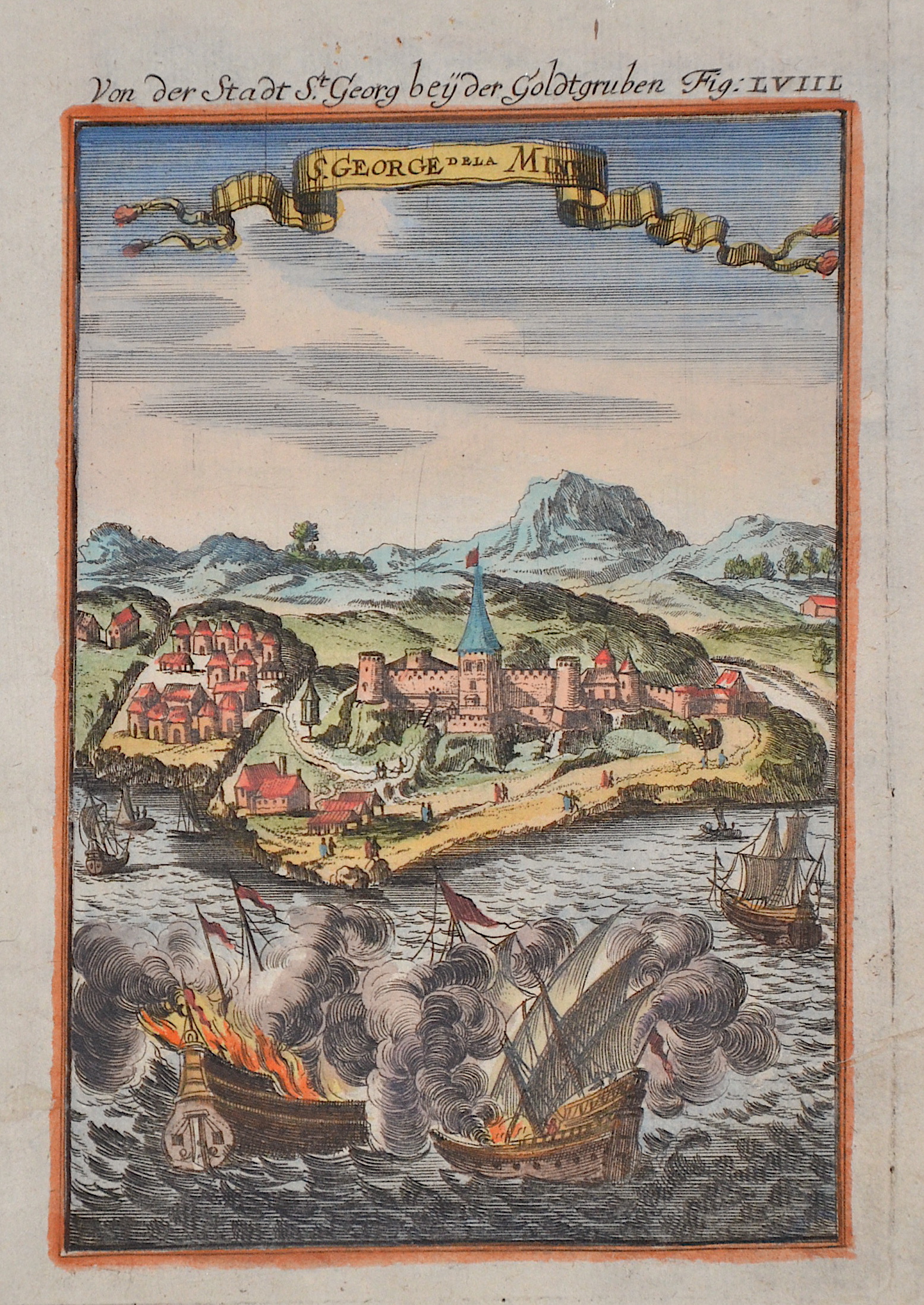
Von der Stadt St. Georg bey der Goldtgruben Fig. LVIIL / S. George de la Mine.

| Article ID | AF0660 |
Title | Von der Stadt St. Georg bey der Goldtgruben Fig. LVIIL / S. George de la Mine. |
Description | View of St. George's Castle or Elmina Castle in Ghana with sailing ships in front. |
| Year | ca. 1719 |
Artist | Mallet (1630-1706) |
Alain Manesson Mallet (1630- 1706 ) was a French cartographer and engineer. He started his career as a soldier in the army of Louis XIV, became a Sergeant-Major in the artillery and an Inspector of Fortifications. He also served under the King of Portugal, before returning to France, and his appointment to the court of Louis XIV. His military engineering and mathematical background led to his position teaching mathematics at court. His major publications were Description de L'Univers (1683) in 5 volumes, and Les Travaux de Mars ou l'Art de la Guerre (1684) in 3 volumes. His Description de L'Universe contains a wide variety of information, including star maps, maps of the ancient and modern world, and a synopsis of the customs, religion and government of the many nations included in his text. It has been suggested that his background as a teacher led to his being concerned with entertaining his readers. This concern manifested itself in the charming harbor scenes and rural landscapes that he included beneath his description of astronomical concepts and diagrams. Mallet himself drew most of the figures that were engraved for this book. | |
Historical Description | The first inhabitants of Ghana were members of the Sango or Sangoan culture - named after the first locations in Sango Bay on the Ugandan side of Lake Victoria. The population strata in Ghana and Togo, which are now considered to be autochthonous, are essentially groups who immigrated in large groups from the north or northeast to the areas south of the savannah belt of Togo and Ghana from the 9th and 10th centuries. This migratory movement was triggered by a change in the climate, which was associated with changes in the vegetation of the savannah areas. The modern state of Ghana takes its name from the ancient Kingdom of Ghana, which was geographically located a few thousand kilometers northwest and has no ethnic or historical connection to the current state of Ghana. In the pre-colonial period there were several large empires or federations on the territory of the present-day state. The first of these states, the empires of Dagomba, Mamprusi or Gonja, arose in the savannah region in northern Ghana and was culturally shaped by the empire of the Mossi further north and by Islam. Around 1600 the Ashanti Empire began to rise in central Ghana to become the dominant power in all of present-day Ghana. On the Gold Coast, the fortified settlements of European powers (Portuguese, English, Dutch, Brandenburgers, Swedes, Danes) have been lined up in a density like in no other area of Africa since the 17th century. Around 1820 the Colonial Office took over the British trading post on the Gold Coast. An agreement was reached between the British and the Fanti to defend themselves against the Ashanti from inland. In 1874 the British declared the coastal strip a crown colony. In 1957 the British crown colony Gold Coast and British Togoland became independent under the name Ghana. |
| Place of Publication | Frankfurt on Main |
| Dimensions (cm) | 14,5 x 9,5 cm |
| Condition | Tear external margin perfectly restored |
| Coloring | original colored |
| Technique | Copper print |