

Adina Sommer
Antique and Contemporary Art
Winzerer Str. 154
80797 München
telephone
+49 89 304714
business hours:
by appointment
Email
![]()


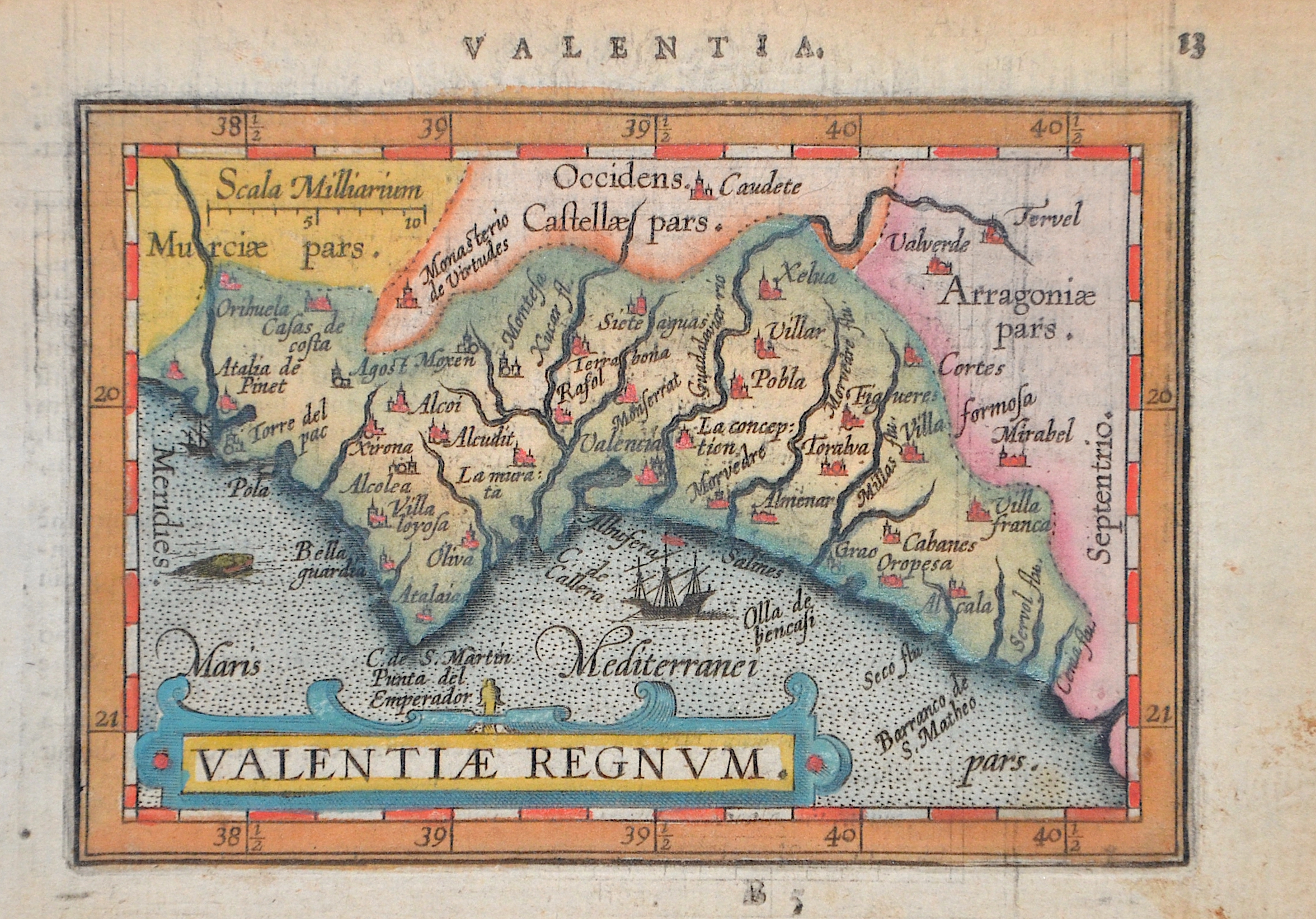
Valenciae Regnum. /Valentia. 13

| Article ID | EUE1608 |
Title | Valenciae Regnum. /Valentia. 13 |
Description | Map shows the whole of Valencia with title cartouche, sea monster and two sailing ships. From "Abraham Ortelius His epitome of the Theater of the Worlde." by Coignet Michel (1549-1623), cartographer Abraham Ortelius, printed by James Shawe, London. |
| Year | ca. 1603 |
Artist | Ortelius (1527-1598) |
Abraham Ortelius, (1527 - 1598) Antwerp, comes from an Augsburg family and was born in Antwerp, Spain, where he lived throughout his life. After thorough training, he joined the Antwerp Guild of St. Luke in 1547 as a card painter. In 1554 he took over an antiquarian bookshop that mainly deals with the coloring, distribution and publishing of maps. Basically he is more of a publisher than a scholar. And so he also made the acquaintance of another great man of his time, Gerhard Mercator (1512-1594), who encouraged him to draw cards and to make maps of the most varied of countries. His first cartographic work of his own is a large 8-sheet map of the world that appears in Antwerp in 1564. This is followed by a two-sheet map of Egypt (1565) and another of Asia (1567). The great achievement of Ortelius, who was one of the most famous European cartographers of his time, and the enthusiastic reception of his theater, mark a decisive turning point in the history of the world map. The new path is mapped out with the Theatrum. For the general view of the world, the appearance of Ortelius-Theatrum is important insofar as it emphatically confirms that America is a completely independent continent, which is also not connected to the Asian mainland mass at its northern tip. Ortelius was the first to come up with the idea of producing a handy collection of reliable maps, all kept in the same format and only by the same author for each country. These sheets could also be bound into a book for easy storage and use. Mercator, who also realized the idea of a world atlas from 1569, persuaded his friend to publish the famous Theatrum Orbis Terrarrum. Ortelius collected, traveled, corresponded and negotiated for 10 years before he could have his work printed in the best European printing house (Plantijn / Amsterdam). In addition to technical difficulties, Ortelius had to submit to the political / religious conditions, since maps were also subject to strict scrutiny during the Inquisition. Biblical scenes are pleasant, portraits of outstanding Catholics are welcome, but not family coats of arms or other emblems that could be politically suspect. On May 20, 1570, his first edition of the Theatrum Orbis Terrarum, the first collection of maps in book form, was published, financed and edited by Gillis Hooftman, an Antwerp merchant, banker and shipowner. Atlases did not yet have this name at that time. This collection was published between 1570 and 1612 in 42 editions and in 7 languages: Latin, German, Dutch, French, Spanish, English and Italian. Unlike his professional colleagues, he clearly referenced the sources of his maps and texts. The work contains, among other things, an illustration of the world known until 1492 and was therefore already looking back at the time the map was created. | |
Historical Description | The Valencian Community, also Valencian Land is an autonomous community of Spain located on the Mediterranean coast. It borders Catalonia to the north, Aragon and Castile-La Mancha to the west, and Murcia to the south, and includes the three provinces of Valencia, Alicante and Castellón de la Plana. The capital of the autonomous community is the city of Valencia. The territory of the Autonomous Community, formed in 1982, is largely identical to that of the former Kingdom of Valencia, which belonged to the Crown of Aragon. Most of the region belongs to the linguistic area of Valencian, a variety of Catalan. Valencian is an official language alongside Spanish. |
| Place of Publication | Antwerp |
| Dimensions (cm) | 9 x 12 cm |
| Condition | Perfect condition |
| Coloring | original colored |
| Technique | Copper print |
Reproduction:
36.00 €
( A reproduction can be ordered individually on request. )