

Adina Sommer
Antique and Contemporary Art
Winzerer Str. 154
80797 München
telephone
+49 89 304714
business hours:
by appointment
Email
![]()


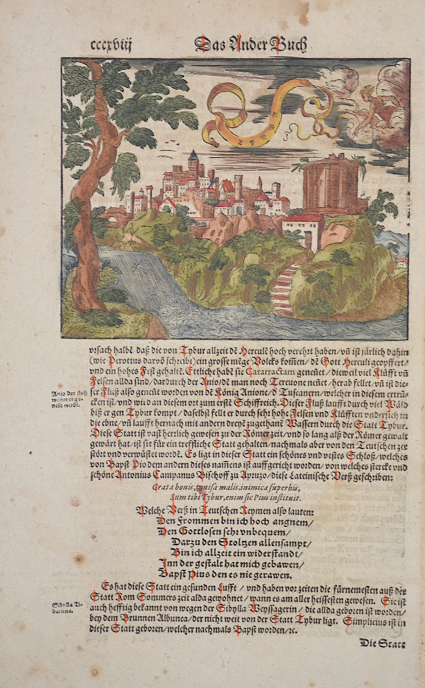
Tybur

| Article ID | EUI1518 |
Title | Tybur |
Description | Map shows the city Tivoli, on the backside a representation of a punishment of a citizen and a beacon. |
| Year | ca. 1550 |
Artist | Münster (1489-1552) |
Sebastian Münster (1489–1552) was a leading Renaissance cosmographer. His most famous work, the Cosmographia (1544), was a comprehensive description of the world with 24 maps, based on research dating back to 1528. Continuously revised, the 1550 edition already included many new maps. It was the first scientific yet accessible world description published in German, illustrated with numerous woodcuts by artists such as Hans Holbein the Younger. Between 1544 and 1650, the Cosmographia appeared in 46 editions (27 in German) and was translated into several languages. Münster’s work combined the knowledge of scholars, artists, and travelers and remained influential long after his death. | |
Historical Description | Central Italy is the central section of the Italy peninsula, which is divided into northern Italy, central Italy and southern Italy. It stretches from the Apennine ridge between La Spezia and Rimini to the historic northern border of the Kingdom of Naples. The southern boundary today runs along the rivers Tronto and Garigliano after changes in the provinces in the 1920s. Central Italy is formed by the regions of Tuscany, Umbria, Marche and Lazio, whereby only Tuscany can be linguistically and culturally uniformly classified as Central Italy. Within these borders, central Italy also forms one of the five Italian macro regions. In ancient times, in northern Italy, unlike in southern Italy, there was hardly any Greek colonization. For the Roman Empire, Northern Italy was initially Gallia cisalpina. Since the Middle Ages, northern Italy has been characterized by remarkable trading cities, which, starting from the Veronese Confederation, united in the Lombardenbund against Emperor Barbarossa. The history of Italy, documented by written sources, begins only after the settlement by Italian peoples. Alongside them, the culture of the Etruscans, whose origin is unknown, was experienced around 600 BC. Their heyday. In the 8th century BC The Greek colonization of the southern Italian mainland and Sicily had begun, and Phoenicians settled on the west coast of the island. These colonies later belonged to Carthage. From the 4th century BC began the expansion of Rome. From the 5th century Italy came under the rule of Germanic tribes, the population declined drastically until around 650, and Ostrom briefly conquered the former core area of the empire in the 6th century. In the 8th century, the north, ruled by the Lombards for about two centuries, was annexed to the Franconian Empire, later to the Holy Roman Empire, while Arabs and Byzantines ruled in the south from the 11th century onwards. In most regions, feudalism prevailed in the early Middle Ages. The northern Italian municipalities, which came together in the Lombardenbund, were able to free themselves from the influence of the empire in the 12th and 13th centuries and establish their own territories. Of this multitude of territories, the most important were Milan, the sea powers Genoa and Venice, Florence and Rome, and the south of Italy, which was partly French and partly Spanish. After four centuries of fragmentation and foreign rule, the peninsula became politically united in the course of the Risorgimento national movement. The modern Italian state was founded in 1861. |
| Place of Publication | Basle |
| Dimensions (cm) | 27,5 x 16 cm |
| Condition | Very good |
| Coloring | original colored |
| Technique | Woodcut |