

Adina Sommer
Antique and Contemporary Art
Winzerer Str. 154
80797 München
telephone
+49 89 304714
business hours:
by appointment
Email
![]()


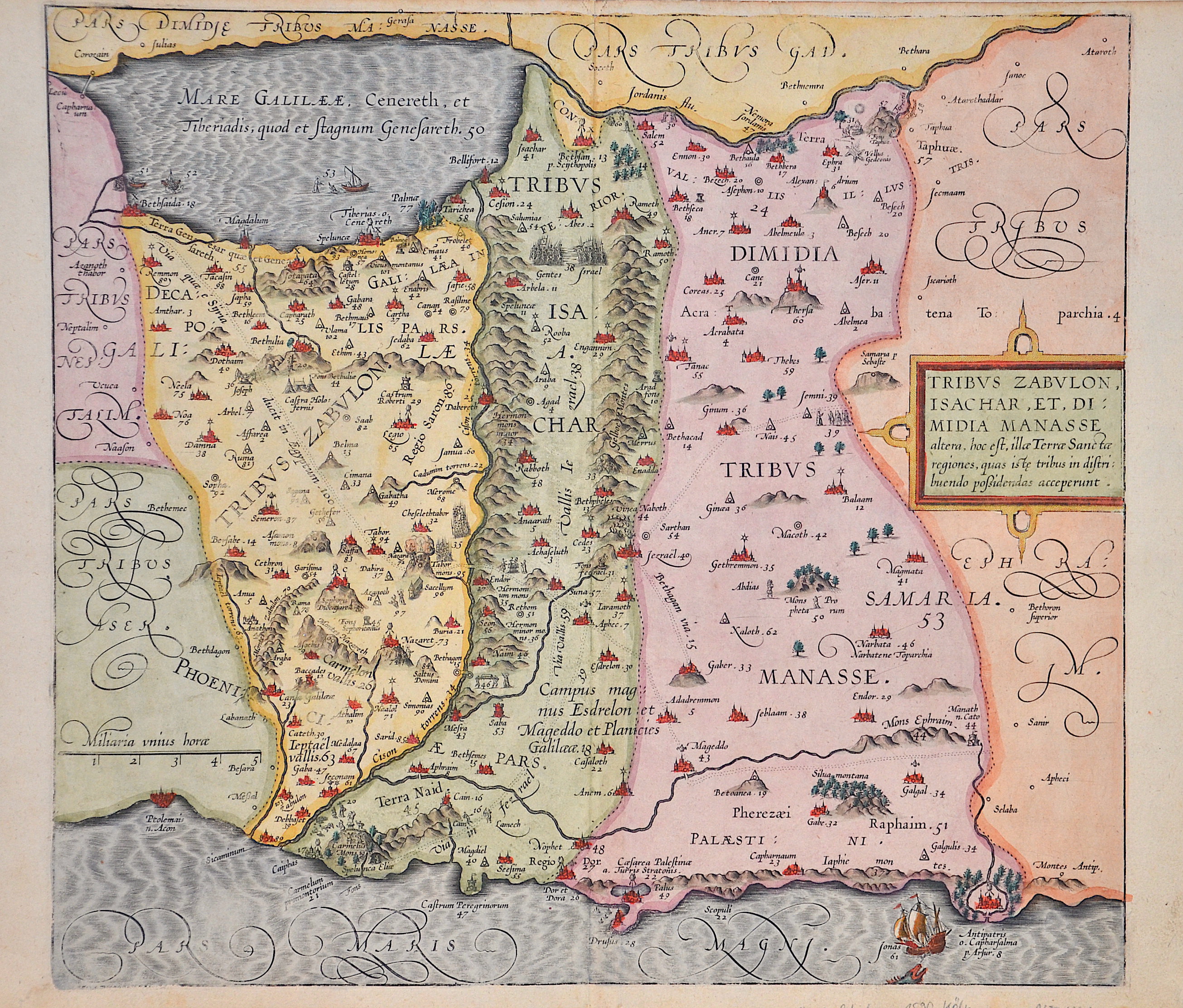
Tribus Zabulon, Isachar, et, dimidia Manasse altera, hoc est, illae Terrae Sanctae regiones,…

| Article ID | AST1061 |
Title | Tribus Zabulon, Isachar, et, dimidia Manasse altera, hoc est, illae Terrae Sanctae regiones,… |
Description | Decorative and rare map of the lands granted to the Tribes of Zabulon or Zebulun, Issachar or Isachar and the western half of the tribe of Manasseh at the time of Joshua's division of the Twelve Tribes. The map shows the Sea of Galilee westward to the Mediterranean. Many Biblical illustrations include a dramatic scene where Jonas is being cast from a sailing ship into the open maw of the awaiting whale. This map, among the most attractive of the series, shows the Sea of Galilee in full with several scenes from the life of Jesus, including the walking on water episode, Jesus preaching from a boat, and others. This map is the fourth of ten maps of the Holy Land prepared by Christian van Adrichem for publication in his Theatrum Terrae Sanctae. Adrichem's maps for the Theatrum were made between 1580 and 1585, but were published posthumously by his associate, Gerardis Brunius of Koln, in 1590. The publication went through several later editions and served as a basis for most subsequent maps of the Holy Land well into the 18th century. |
| Year | ca. 1590 |
Artist | Adrichem, van (1533-1585) |
Christian A. or van Adrichum, born in Delft (1533- 1585) son of Adrian Klaasz, mayor of Delft, devoted himself to theology, was ordained priest in 1566. He was mainly concerned with Jerusalem and the Holy Land. He published under the Latin name Adrichomius: "Iervsalem, sicvt Christi tempore florvit, et suburbanorum, insigniorumque historiarum eius breuis descriptio". Theatrum terrae Sanctae et Biblicarvm Historiarvm cum tabulis geographicis", To this Theatrum, also translated into different languages, is attached a "Chronicon duplex". Adrichem's writings are worked with great diligence, they are very often used and are still partly cited today. | |
Historical Description | The first archaeologically proven traces of an early or proto-Israelite settlement in the Mashrek region go back to the period between the 12th and 11th centuries BC. BC back. According to biblical tradition, Jerusalem was founded around 1000 BC. Conquered by David from the Jebusites and chosen as the capital of his great empire. The country subsequently became part of the Persian Empire, then the Empire of Alexander the Great, and finally the Empire of the Seleucids. The Maccabees revolt in 165 BC BC brought Israel once more state independence for about 100 years. 63 BC The time of Roman supremacy began. The Romans divided the area into two provinces: Syria in the north, Judea in the south. In the course of the Islamic expansion, the area came under Arab rule in 636. Since then, Palestine has been predominantly inhabited by Arabs. The crusaders ruled from 1099 to 1291 what they called the "Latin Kingdom of Jerusalem". This was followed by the Mamluks from 1291 to 1517 and then the Ottoman rule from 1517 to 1918. None of these authorities had planned their own administration for Palestine or viewed the area as an independent geographical unit. The region was also part of Syria for the Ottomans, probably going back to the Roman name Syria. |
| Place of Publication | Cologne |
| Dimensions (cm) | 36 x 39,5 cm |
| Condition | Perfect condition |
| Coloring | original colored |
| Technique | Copper print |