

Adina Sommer
Antique and Contemporary Art
Winzerer Str. 154
80797 München
telephone
+49 89 304714
business hours:
by appointment
Email
![]()


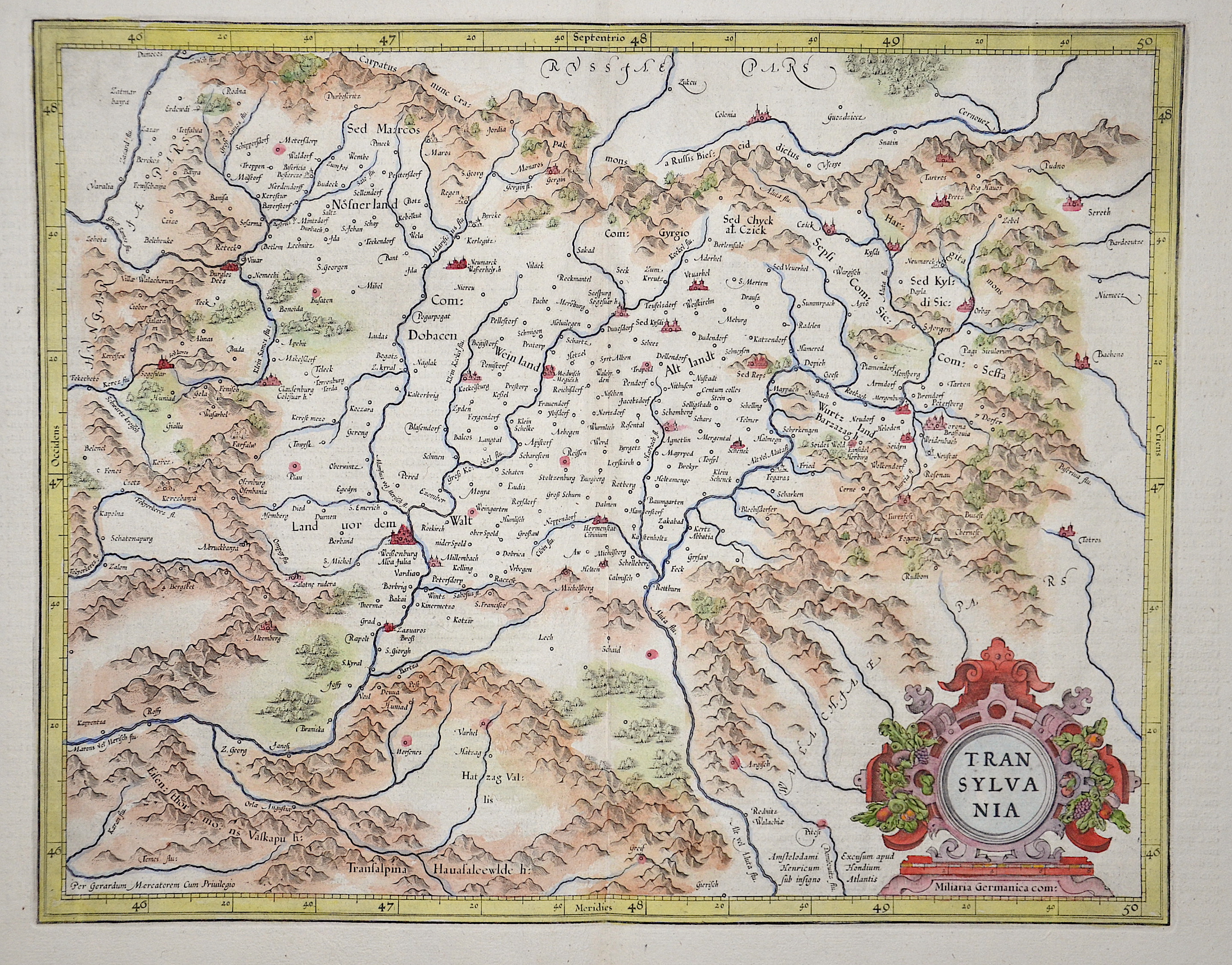
Transylvania

| Article ID | EUR1957 |
Title | Transylvania |
Description | Map shows the entire Transylvania with a magnificent cartouche and detailed representation of the cities, forests, and mountains. Typical depiction of the country in heart shape! |
| Year | ca. 1595 |
Artist | Mercator (1512-1594) |
Gerardus Mercator (1512 - 1594). He was a cartographer, philosopher and mathematician. He is best known for his work in cartography, in particular the world map of 1569 based on a new projection which represented sailing courses of constant bearing as straight lines. He is renowned to the present day as the cartographer who created a world map based on a new projection which represented sailing courses of constant bearing as straight lines. In his own day he was the world's most famous geographer but in addition he had interests in theology, philosophy, history, mathematics and magnetism as well as being an accomplished engraver, calligrapher and maker of globes and scientific instruments. He wrote few books but much of his knowledge is to be found in the copious legends on his wall maps and the prefaces that he composed for his atlas ,the first in which the term "atlas" appears and the sections within it. | |
Historical Description | The area where today's Transylvania is located was the political center of the Dacian Kingdom in ancient times. From about 895, in the course of their land seizures, the Hungarians settled the Carpathian Basin and thus also the area of present-day Transylvania. The political power in the Carpathian region fell to the Hungarians quite unresistingly compared to other land grabs of the Migration Period, as the population groups encountered there formed only some weak ruling structures. Between 1211 and 1225, the Order of Teutonic Knights was also present, which the Hungarian king Andrew II had called into the country to protect it from the Cumans in Burzenland. The Order settled its territory with German settlers. When the knights, encouraged by the Pope and the Grand Master, tried to establish their own state, they were expelled and the Burzenland was annexed to the king's territory. The region of Transylvania developed as a part of the medieval kingdom of Hungary. When the Hungarian army was devastatingly defeated by Suleyman I in the Battle of Mohács on August 29, 1526, an almost 200-year period of constant threat to the country began. The Turkish advance into Hungary (1526-1686) devastated central Hungary in particular. Suleyman I concluded a peace treaty with John Zápolya as early as 1528, counting on the weakening of the Habsburg Empire through what would later become the Principality of Transylvania. For Transylvania as a social and economic entity, the 17th century was a time of great upheaval and constant threat from outside and within. After the victory over the Ottomans at the Second Vienna Turkish Siege of 1683, Transylvania tried in vain to resist the growing influence of Austria. The Peace of Sathmar in 1711 finally established Austrian control over all of Hungary and Transylvania. Transylvania, which remained independent from the Kingdom of Hungary, was now administered by so-called gubernators under the supervision of the Viennese court. From 1733, the ethnic group of the so-called Transylvanian Landler was settled in southern Transylvania. In the meantime, the Romanians constituted the majority of the population of Transylvania. Due to their large numbers and proximity to the Kingdom of Romania, the Romanians resisted Magyarization and found themselves systematically disadvantaged by the ruling Hungarians on many levels. The takeover of Transylvania by Romania was enshrined in the Treaty of Trianon in 1920. |
| Place of Publication | Amsterdam |
| Dimensions (cm) | 33,5 x 42,5 cm |
| Condition | Margins mounted |
| Coloring | original colored |
| Technique | Copper print |