

Adina Sommer
Antique and Contemporary Art
Winzerer Str. 154
80797 München
telephone
+49 89 304714
business hours:
by appointment
Email
![]()


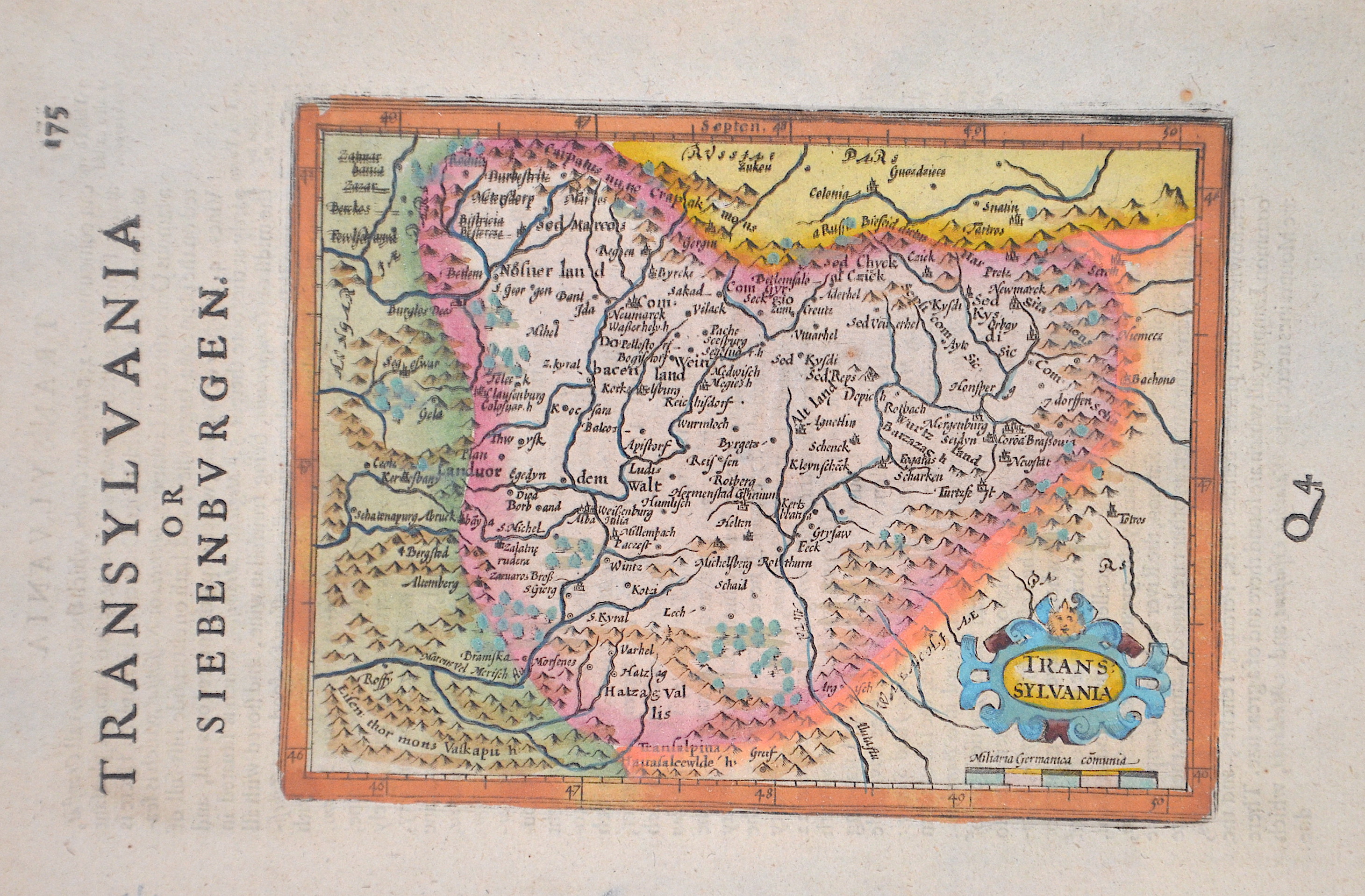
Transilvanien

| Article ID | EUR1380 |
Title | Transilvanien |
Description | Map shows the entire Transylvania (Siebenbürgen) with a detailed representation of cities, forests, mountains, and a title cartouche. |
| Year | ca. 1620 |
Artist | Hondius (1597-1650) |
Jodocus Hondius (1563 –1612) was a Dutch engraver, and cartographer. He is best known for his early maps of the New World and Europe, for re-establishing the reputation of the work of Gerard Mercator, and for his portraits of Francis Drake. He helped establish Amsterdam as the center of cartography in Europe in the 17th century. He was born in Wakken and grew up in Ghent. In his early years he established himself as an engraver, instrument maker and globe maker. In 1584 he moved to London to escape religious difficulties in Flanders. While in England, Hondius was instrumental in publicizing the work of Francis Drake, who had made a circumnavigation of the world in the late 1570s. In particular, in 1589 Hondius produced a now famous map of the bay of New Albion, where Drake briefly established a settlement on the west coast of North America. Hondius' map was based on journal and eyewitness accounts of the trip and has long fueled speculation about the precise location of Drake's landing, which has not yet been firmly established by historians. Hondius is also thought to be the artist of several well-known portraits of Drake that are now in the National Portrait Gallery in London. In 1593 he moved to Amsterdam, where he remained until the end of his life. In co-operation with the Amsterdam publisher Cornelis Claesz. in 1604 he purchased the plates of Gerard Mercator's Atlas from Mercator's grandson. Mercator's work had languished in comparison to the rival Theatrum Orbis Terrarum by Ortelius. Hondius republished Mercator's work with 36 additional maps, including several which he himself had produced. Despite the addition of his own contributions, Hondius gave Mercator full credit as the author of the work, listing himself as the publisher. Hondius' new edition of Mercator's work was a great success, selling out after a year. Hondius later published a second edition, as well as a pocket version Atlas Minor. The maps have since become known as the ""Mercator/Hondius series"" . In the French edition of the Atlas Minor we find one of the first instances of a thematic map using map symbols. This is a map entitled Designatio orbis christiani (1607) showing the dispersion of major religions. Between 1605 and 1610 he was employed by John Speed to engrave the plates for Speed's The Theatre of the Empire of Great Britaine. Hondius died, aged 48, in Amsterdam. After his death, his publishing work in Amsterdam was continued by his widow, two sons, Jodocus II and Henricus, and son-in-law Johannes Janssonius, whose name appears on the Atlas as co-publisher after 1633. Eventually, starting with the first 1606 edition in Latin, about 50 editions of the Atlas were released in the main European languages. In the Islamic world, the atlas was partially translated by the Turkish scholar Katip Çelebi. The series is sometimes called the ""Mercator/Hondius/Janssonius"" series because of Janssonius's later contributions. | |
Historical Description | The area where today's Transylvania is located was the political center of the Dacian Kingdom in ancient times. From about 895, in the course of their land seizures, the Hungarians settled the Carpathian Basin and thus also the area of present-day Transylvania. The political power in the Carpathian region fell to the Hungarians quite unresistingly compared to other land grabs of the Migration Period, as the population groups encountered there formed only some weak ruling structures. Between 1211 and 1225, the Order of Teutonic Knights was also present, which the Hungarian king Andrew II had called into the country to protect it from the Cumans in Burzenland. The Order settled its territory with German settlers. When the knights, encouraged by the Pope and the Grand Master, tried to establish their own state, they were expelled and the Burzenland was annexed to the king's territory. The region of Transylvania developed as a part of the medieval kingdom of Hungary. When the Hungarian army was devastatingly defeated by Suleyman I in the Battle of Mohács on August 29, 1526, an almost 200-year period of constant threat to the country began. The Turkish advance into Hungary (1526-1686) devastated central Hungary in particular. Suleyman I concluded a peace treaty with John Zápolya as early as 1528, counting on the weakening of the Habsburg Empire through what would later become the Principality of Transylvania. For Transylvania as a social and economic entity, the 17th century was a time of great upheaval and constant threat from outside and within. After the victory over the Ottomans at the Second Vienna Turkish Siege of 1683, Transylvania tried in vain to resist the growing influence of Austria. The Peace of Sathmar in 1711 finally established Austrian control over all of Hungary and Transylvania. Transylvania, which remained independent from the Kingdom of Hungary, was now administered by so-called gubernators under the supervision of the Viennese court. From 1733, the ethnic group of the so-called Transylvanian Landler was settled in southern Transylvania. In the meantime, the Romanians constituted the majority of the population of Transylvania. Due to their large numbers and proximity to the Kingdom of Romania, the Romanians resisted Magyarization and found themselves systematically disadvantaged by the ruling Hungarians on many levels. The takeover of Transylvania by Romania was enshrined in the Treaty of Trianon in 1920. |
| Place of Publication | Amsterdam |
| Dimensions (cm) | 13 x 17,5 cm |
| Condition | Very good |
| Coloring | original colored |
| Technique | Copper print |