

Adina Sommer
Antique and Contemporary Art
Winzerer Str. 154
80797 München
telephone
+49 89 304714
business hours:
by appointment
Email
![]()


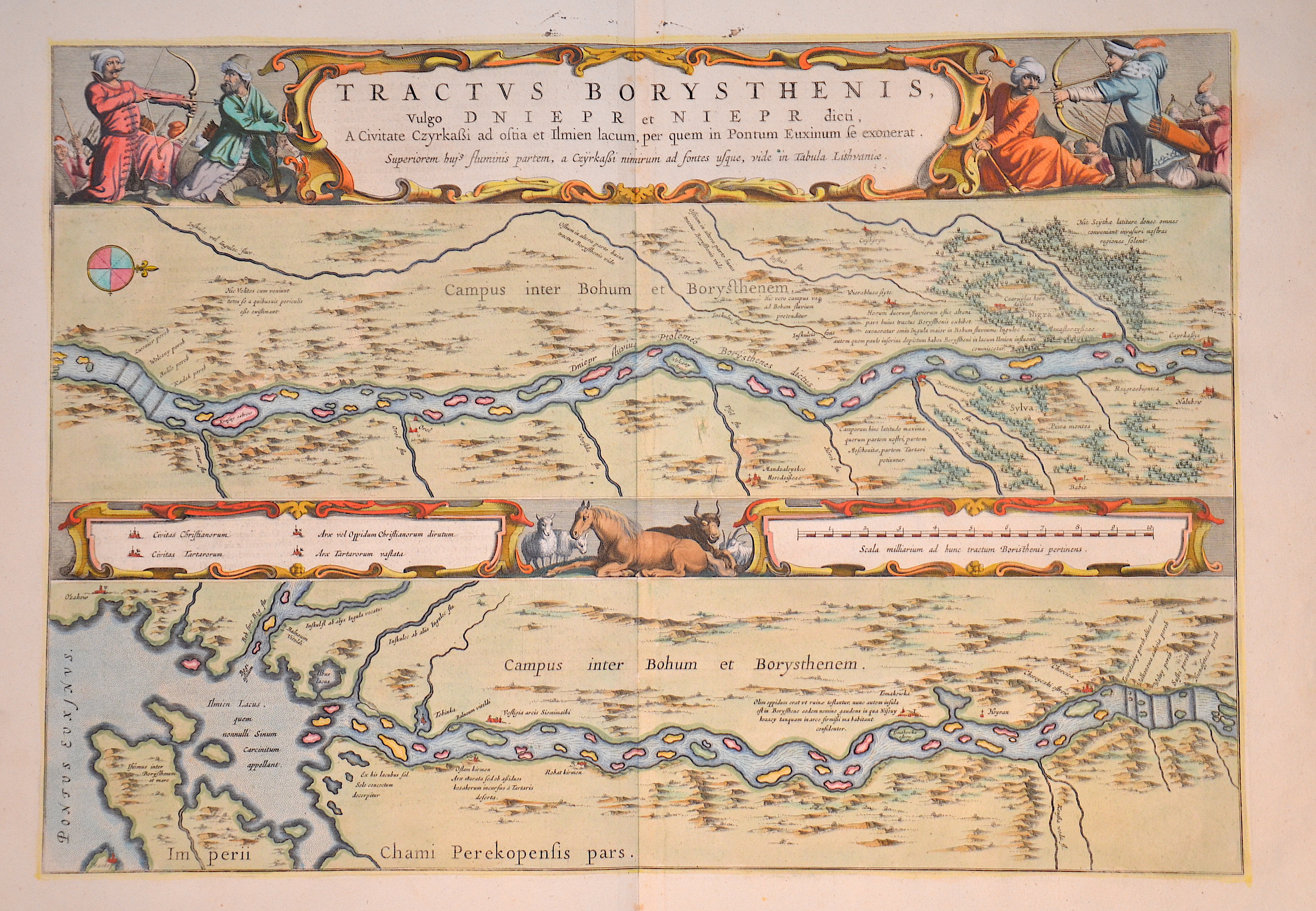
Tractus Borysthenis vulgo Dniepr et Niepre dicti a Civitate Czyrkaßi ad ostia..

| Article ID | EUO2866 |
Title | Tractus Borysthenis vulgo Dniepr et Niepre dicti a Civitate Czyrkaßi ad ostia.. |
Description | Map shows the upper part of the river Dniepr in two parts, upper map with compass rose. Magnificent cartouches with title, index, mileage scale, farm animals and warriors. Rückseite in holländischer Sprache. |
| Year | ca. 1660 |
Artist | Blaeu (1571-1638) |
Joan Guilliemus Blaeu was the eldest son of Willem Janszoon Blaeu (1571-1638), and was probably born in Alkmaar in the province of Noord-Holland in the final years of the 16th century. He was brought up in Amsterdam, and studied law at the University of Leiden before going into partnership with his father in the 1630s. Although his father Willem had cartographic interests, having studied under the Danish astronomer Tycho Brahe and having manufactured globes and instruments, his primary business was as a printer. It was under the control of Joan that the Blaeu printing press achieved lasting fame by moving towards the printing of maps and expanding to become the largest printing press in Europe in the 17th century. By the 1660s the Theatrum Orbis Terrarum (or Atlas Maior as it had became known by this time) had expanded to between 9 and 12 volumes, depending on the language. With over 3,000 text pages and approximately 600 maps, it was the most expensive book money could buy in the later 17th century. The translation of the text from Latin into Dutch, English, German, French, and Spanish for several volumes created enormous work for those involved in typography and letterpress activities. It is estimated that over 80 men must have been employed full-time in the Blaeu printing house in Bloemgracht, not including engravers who worked elsewhere, with over 15 printing presses running simultaneously, and in 1667 a second press was acquired at Gravenstraat. At the same time as producing the Atlas Maior, Blaeu was also publishing town plans of Italy, maps for globes, and other volumes. At its peak the Blaeu press managed to produce over 1 million impressions from 1,000 copper plates within four years. | |
Historical Description | The Dnieper has undergone several name changes. The early ancient Greeks and Romans called the river Borysthénēs, which in Scythian means "wide land", ,.In late antiquity Greek-Latin texts call it Danapris or Danaper, after its Sarmatian name :dānu apara, "distant river". By the Huns the river was called Var , which originally denotes the Kuban or one of its tributaries and derives from the Sarmatian *var-dānu "wide river" (Ptolemy ). The river rises in Russia in the Waldai Heights, about 200 kilometers west of Moscow. Near the village of Bocharovo there is the spring area, which has been a natural monument since 1981. The spring was described already in the late 17th century. It is located only a few kilometers from the main water divide point Baltic Sea-Black Sea-Caspian Sea. In addition to cargo transport (mainly mining products, building materials, timber and grain), the Dnieper River is also used for river cruises and excursions on passenger ships from the ports of the major cities on its banks. |
| Place of Publication | Amsterdam |
| Dimensions (cm) | 38 x 54 cm |
| Condition | Perfect condition |
| Coloring | original colored |
| Technique | Copper print |