

Adina Sommer
Antique and Contemporary Art
Winzerer Str. 154
80797 München
telephone
+49 89 304714
business hours:
by appointment
Email
![]()


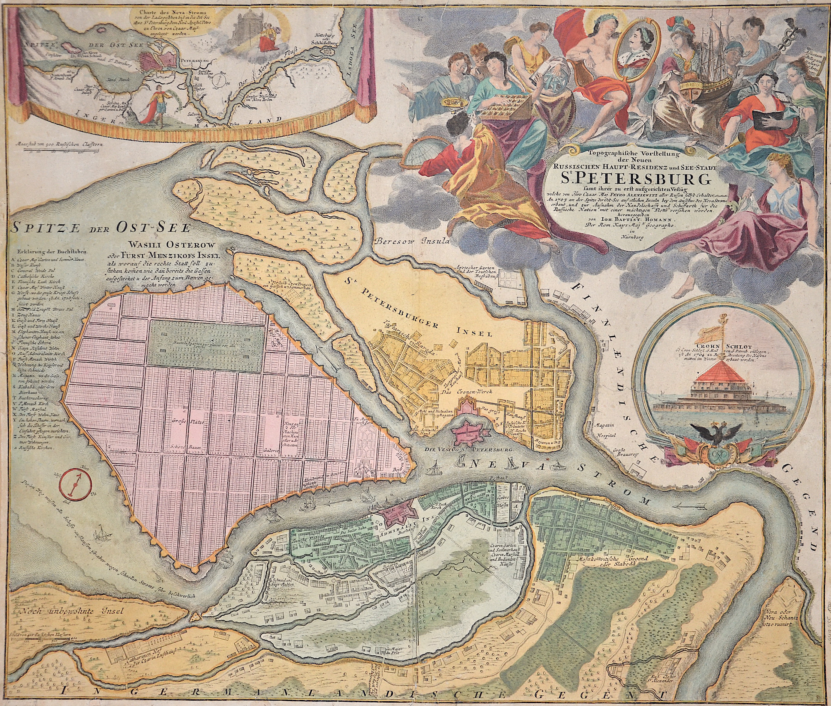
Topographische Vorstellung der Neuen Russischen Haupt-Residenz und See- Stadt St. Petersburg sammt ihrer zu erst aufgerichten Festung

| Article ID | EUO655 |
Title | Topographische Vorstellung der Neuen Russischen Haupt-Residenz und See- Stadt St. Petersburg sammt ihrer zu erst aufgerichten Festung |
Description | Map shows the city map of St. Petersburg with a magnificent cartouche, a partial map with a plan of St. Petersburg and the Chronschloss. |
| Year | ca. 1710 |
Artist | Homann (1664-1724) |
Johann Babtiste Homann (1664-1724), Nuremberg, was born in Oberkammlach, the Electorate of Bavaria. Although educated at a Jesuit school, and preparing for an ecclesiastical career, he eventually converted to Protestantism and from 1687 worked as a civil law notary in Nuremberg. He soon turned to engraving and cartography; in 1702 he founded his own publishing house. Homann acquired renown as a leading German cartographer, and in 1715 was appointed Imperial Geographer by Emperor Charles VI. Giving such privileges to individuals was an added right that the Holy Roman Emperor enjoyed. In the same year he was also named a member of the Prussian Academy of Sciences in Berlin. Of particular significance to cartography were the imperial printing privileges (Latin: privilegia impressoria). These protected for a time the authors in all scientific fields such as printers, copper engravers, map makers and publishers. They were also very important as a recommendation for potential customers. In 1716 Homann published his masterpiece Grosser Atlas ueber die ganze Welt (Grand Atlas of all the World). Numerous maps were drawn up in cooperation with the engraver Christoph Weigel the Elder, who also published Siebmachers Wappenbuch. Homann died in Nuremberg. He was succeeded by the Homann heirs company, which was in business until 1848. The company was known as Homann Erben, Homanniani Heredes, or Heritiers de Homann abroad. | |
Historical Description | In the area of St. Petersburg since the 10th century representatives of various Finno-Ugric peoples lived mostly on agriculture. At the beginning of the 14th century, Sweden and Novgorod quarreled over the area. A Swedish settlement at this place, handed down as Landskrona, was allegedly destroyed in 1301. After that, it was agreed that the region should be considered as a buffer zone between the spheres of influence, where no fortresses could be built. In the following centuries, the area was used at least as a landing place for ships sailing on the Neva River, and possibly as a trading center. The latter certainly applies to the period of renewed Swedish dominance in the region after the construction of the Nyenschanz fortress in 1611 and the Nyen settlement that soon surrounded it. Both were located in the urban area of present-day Saint Petersburg on the northern (or right) bank of the Neva River. There is evidence of major urban development ambitions of the Swedes for Nyen in the 17th century. However, these suffered a severe setback when the settlement and fortress were destroyed by Russian troops in 1656 during the Second Northern War. Reconstruction was soon followed by the final conquest of Nyenschanz on May 1, 1703, during the Great Northern War, by the Russians under Sheremetev, who were advancing down the Neva. Nyen had already been preemptively cleared and partially destroyed by the Swedes themselves by this time. The end of Nyen and Nyenschanz simultaneously marked the beginning of the city history of Saint Petersburg in 1703, the year in which the foundation stone for the Peter and Paul Fortress, named after the Tsar's namesake, was laid on an island opposite Nyenschanz in the Neva Delta. |
| Place of Publication | Nuremberg |
| Dimensions (cm) | 50 x 58 cm |
| Condition | Tear on the right side perfectly restored,Top left corner attached |
| Coloring | original colored |
| Technique | Copper print |