

Adina Sommer
Antique and Contemporary Art
Winzerer Str. 154
80797 München
telephone
+49 89 304714
business hours:
by appointment
Email
![]()


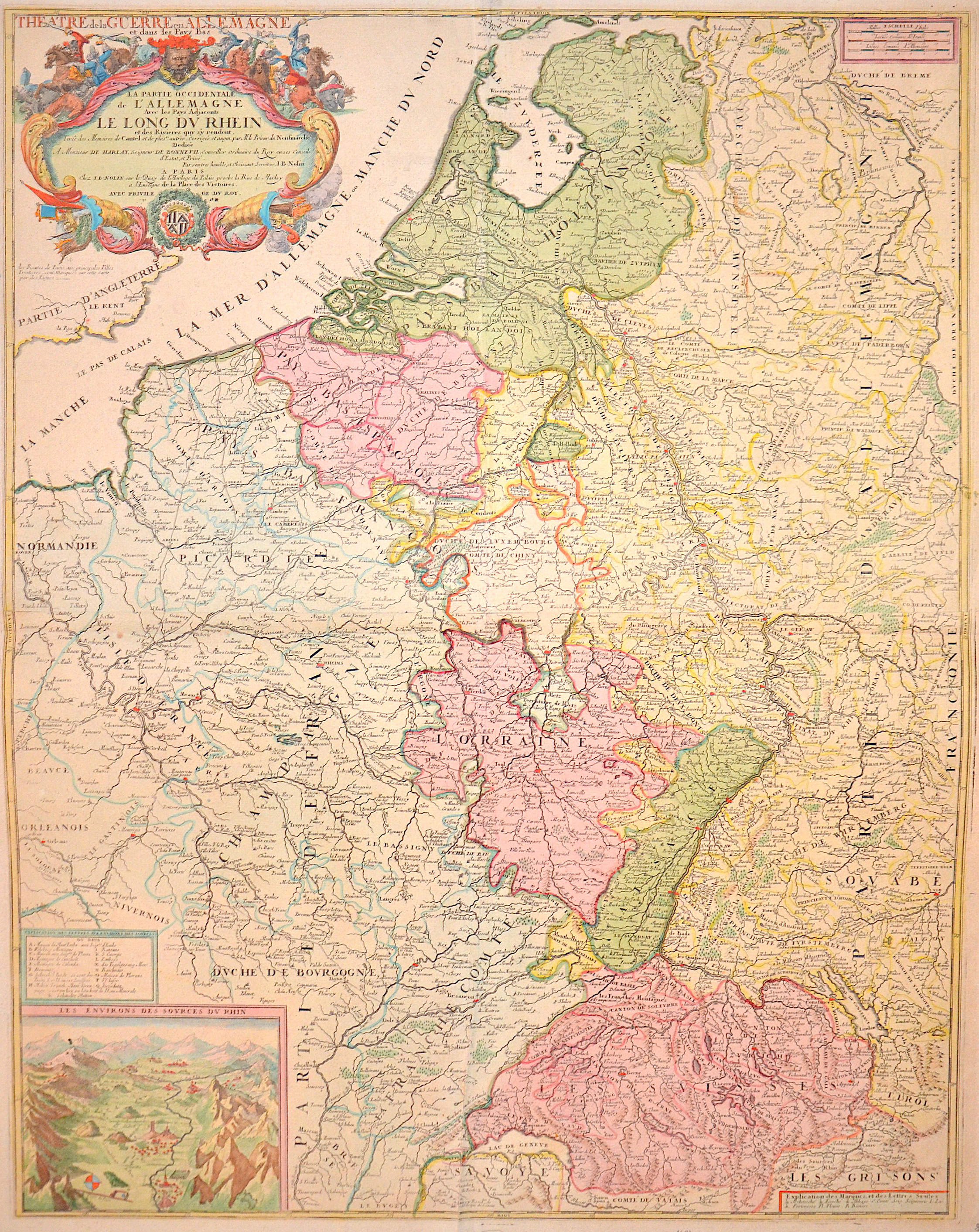
Theatre de la Guerre en Allemagne et dans les Pays Bas / La Partie Occidentale de L’ Allemagne le long du Rhein et des Rivieres quy s’y rendent.

| Article ID | EUD3394 |
Title | Theatre de la Guerre en Allemagne et dans les Pays Bas / La Partie Occidentale de L’ Allemagne le long du Rhein et des Rivieres quy s’y rendent. |
Description | Magnificent map showing the entire course of the Rhine from Lake Constance to the North Sea, a title cartouche and mileage scale. Also a partial map from the bird's-eye view of the confluence of the Anterior and Posterior Rhine at Reichenau (labeled N in the index). |
| Year | ca. 1689 |
Artist | Nolin (1657-1725) |
Jean-Baptiste Nolin (ca. 1657-1708) set up the family publishing business in Paris. Many of his maps were based on the work of Vincenzo Coronelli and Sieur de Tillemon. His son (1686-1762), continued the business for many years and prepared an Atlas General which was published posthumously in 1783. | |
Historical Description | The Rhine is one of the most important rivers in Europe and has played a significant role in the history and development of the region. It connects several countries, including Switzerland, Germany, France, and the Netherlands. In ancient Europe, the Rhine was an important border, separating the Roman Empire from the Germanic tribes to the north. The Romans used the Rhine as a trade and transport route and built several fortresses along the river to secure their border, including the well-known Limes (border fortifications). The Rhine played a central role in the spread of Roman culture and civilization in the areas along the river. In the Middle Ages, the Rhine was not only an important trade route but also a strategic political point. Cities like Cologne, Mainz, and Speyer along the Rhine developed into important commercial centers. The river was a central part of the Holy Roman Empire and played a key role in the political power dynamics of the region. In the late 18th and early 19th centuries, the Rhine underwent profound changes. During the French Revolution and the Napoleonic Wars, the Rhineland came under French control, and after Napoleon's downfall, it was controlled by Prussia and other German states, becoming an important part of the newly formed German Confederation. In the 19th century, the Rhine experienced significant economic transformation. With the expansion of the railway network and industrialization, the river became an important trade route for raw materials such as coal and iron. Cities like Düsseldorf, Leverkusen, and Mannheim experienced enormous growth and became industrial centers that directly benefited from access to the Rhine. Thus, the course of the Rhine has not only geographical significance but also a profound political, cultural, and economic impact that spans thousands of years. It has shaped both conflict and cooperation and remains a key resource for the countries through which it flows. |
| Place of Publication | Paris |
| Dimensions (cm) | 80 x 63,5 cm |
| Condition | Printed on 2 sheets joined together |
| Coloring | original colored |
| Technique | Copper print |