

Adina Sommer
Antique and Contemporary Art
Winzerer Str. 154
80797 München
telephone
+49 89 304714
business hours:
by appointment
Email
![]()


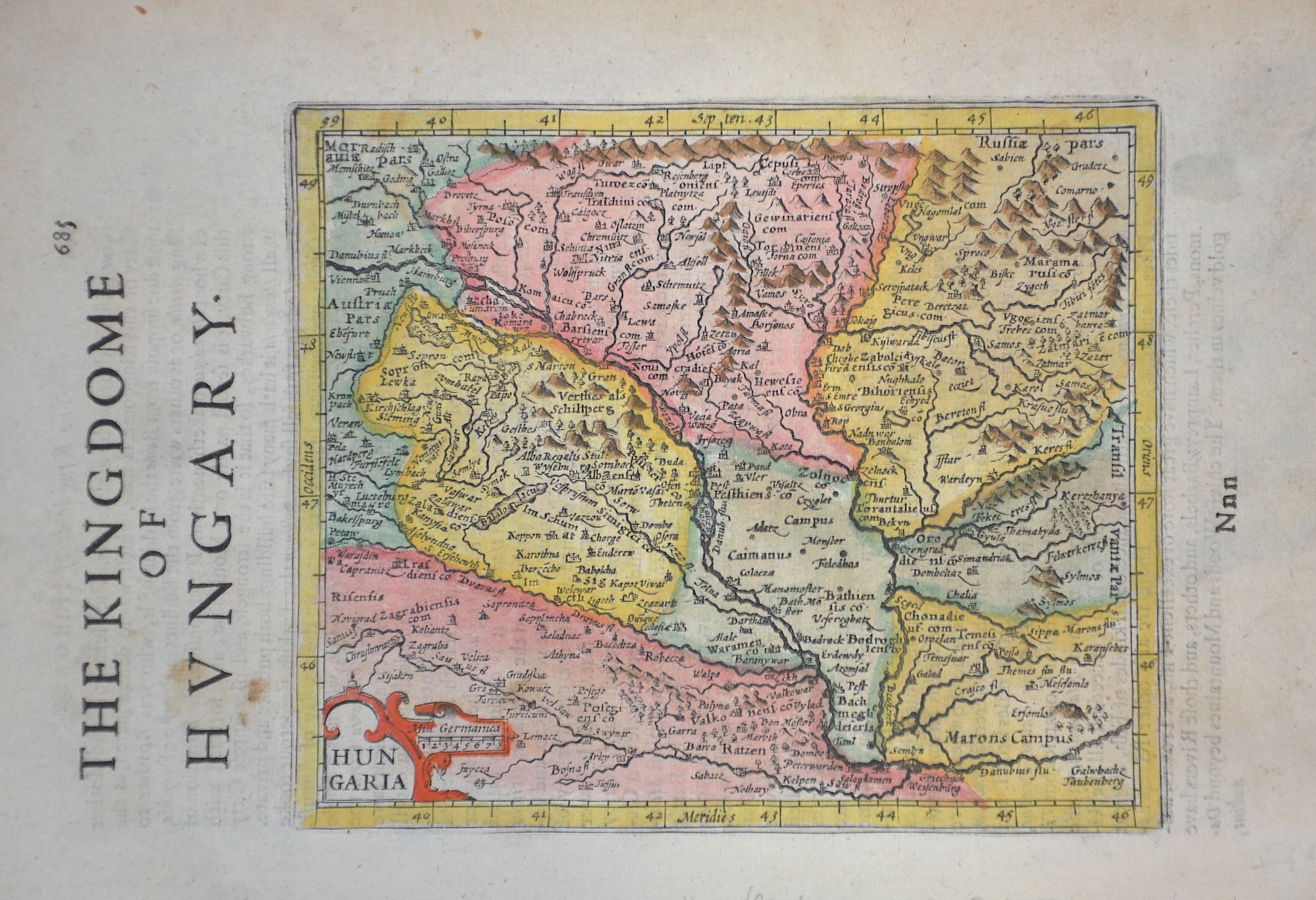
The Kingdom of Hungary

| Article ID | EUH2682 |
Title | The Kingdom of Hungary |
Description | Map shows total Hungary |
| Year | ca. 1600 |
Artist | Hondius/Sparke (1563-1612) |
Jodocus Hondius (1563 –1612) was a Dutch engraver, and cartographer. He is best known for his early maps of the New World and Europe, for re-establishing the reputation of the work of Gerard Mercator, and for his portraits of Francis Drake. He helped establish Amsterdam as the center of cartography in Europe in the 17th century. He was born in Wakken and grew up in Ghent. In his early years he established himself as an engraver, instrument maker and globe maker. In 1584 he moved to London to escape religious difficulties in Flanders. While in England, Hondius was instrumental in publicizing the work of Francis Drake, who had made a circumnavigation of the world in the late 1570s. In particular, in 1589 Hondius produced a now famous map of the bay of New Albion, where Drake briefly established a settlement on the west coast of North America. Hondius' map was based on journal and eyewitness accounts of the trip and has long fueled speculation about the precise location of Drake's landing, which has not yet been firmly established by historians. Hondius is also thought to be the artist of several well-known portraits of Drake that are now in the National Portrait Gallery in London. In 1593 he moved to Amsterdam, where he remained until the end of his life. In co-operation with the Amsterdam publisher Cornelis Claesz. in 1604 he purchased the plates of Gerard Mercator's Atlas from Mercator's grandson. Mercator's work had languished in comparison to the rival Theatrum Orbis Terrarum by Ortelius. Hondius republished Mercator's work with 36 additional maps, including several which he himself had produced. Despite the addition of his own contributions, Hondius gave Mercator full credit as the author of the work, listing himself as the publisher. Hondius' new edition of Mercator's work was a great success, selling out after a year. Hondius later published a second edition, as well as a pocket version Atlas Minor. The maps have since become known as the ""Mercator/Hondius series"" . In the French edition of the Atlas Minor we find one of the first instances of a thematic map using map symbols. This is a map entitled Designatio orbis christiani (1607) showing the dispersion of major religions. Between 1605 and 1610 he was employed by John Speed to engrave the plates for Speed's The Theatre of the Empire of Great Britaine. Hondius died, aged 48, in Amsterdam. After his death, his publishing work in Amsterdam was continued by his widow, two sons, Jodocus II and Henricus, and son-in-law Johannes Janssonius, whose name appears on the Atlas as co-publisher after 1633. Eventually, starting with the first 1606 edition in Latin, about 50 editions of the Atlas were released in the main European languages. In the Islamic world, the atlas was partially translated by the Turkish scholar Katip Çelebi. The series is sometimes called the ""Mercator/Hondius/Janssonius"" series because of Janssonius's later contributions. | |
Historical Description | The Kingdom of Hungary existed in changing borders from 1001 to 1918 and 1920 to 1946, originating in what is now western Hungary and subsequently expanding its domain to include the entire territory of present-day Hungary, as well as the territory of Transylvania, the Kreish and Maramures (both in the Romanian part of the Partium), Slovakia, Vojvodina, the Romanian part of the Banat, Carpatho-Ukraine, Burgenland, Prekmurje, Croatia (except Dalmatia and Istria) and some smaller territories. The first king of the kingdom was Stephen I the Saint from the ruling dynasty of the Árpáds, who was formally recognized as king of Hungary in 1001, when Pope Silvester II granted him the title of "Apostolic Majesty". In 1396, the Ottomans had to face a crusader army under the Hungarian king and later emperor Sigismund, which was crushingly defeated at the Battle of Nicopolis. The European powers, first and foremost the Holy Roman Empire, which had not considered the Ottomans as a serious threat for too long, were faced with the ruins of their policies concerning the Ottoman Empire at the latest with the fall of the medieval Kingdom of Hungary (1526). In the following decades, therefore, the only thing that mattered was to prevent, as far as possible, the further advance of the Ottomans towards Central Europe. In 1526 the decision in the fight against the Ottoman Empire followed in the Battle of Mohács. The Hungarian King Louis II fell in the battle. The following Hungarian Civil War, in which John I was supported by the Turks, ended in 1538 with the Peace of Grosswardein. John Zápolya and Ferdinand were both allowed to continue to use the Hungarian royal title and to rule a part of Hungary. To forestall Habsburg claims, Suleyman I intervened and occupied Buda and central Hungary. Hungary was divided into three parts after 1540 according to the power relations created. The exact demarcation of the borders between the individual parts varied considerably. After the Habsburgs and their allies had pushed the Ottoman Empire back to the territories south of the Danube and the Sava and fixed this in the Peace of Karlowitz in 1699, the Kingdom of Hungary, which had never disappeared de jure, was also restored de facto. The k.u.k. Monarchy existed until its defeat in World War I, when Hungary denounced the Real Union as of October 31, 1918. A short time later, the Hungarian Republic was proclaimed. The kingdom was under several foreign dominations in its history and regained its sovereignty in 1867 as a federal (partial) state of Austria-Hungary. |
| Dimensions (cm) | 14,5 x 21,5 |
| Condition | Very good |
| Coloring | original colored |
| Technique | Copper print |