

- Alsace
- Aquitaine
- Auvergne
- Bourgogne
- Bourgogne-Franche-Comte
- Brittany
- Centre
- Champagne
- Flandre
- France Islands
- Gascogne
- Gironde
- Hauts-de-France
- Ile de France
- Languedoc
- Lothringen
- Midi-Pyrénées
- Nivernais
- Nord-Pas-de-Calais
- Normandie
- Occitanie
- Paris
- Pas-de-Calais
- Pays de la Loire
- Picardie
- Poitou-Charentes
- Provence-Alpes-Cote d Azur
- Pyrénées
- Rhone- Alpes
- Saintonge
- Savoyen
- Tourain
- Westcoast
Adina Sommer
Antique and Contemporary Art
Winzerer Str. 154
80797 München
telephone
+49 89 304714
business hours:
by appointment
Email
![]()


Thann
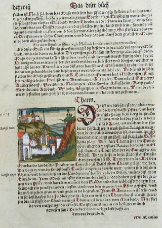
| Article ID | EUF1313 |
Title | Thann |
Map shows the city of Thann in Alsace, on reverse representation of grain thrash | |
| Year | ca. 1550 |
Artist | Münster |
| Place of Publication | Basle |
| Dimensions (cm) | 24 x 17 |
| Condition | Very good |
| Coloring | original colored |
| Technique | Woodcut |
:
9.00 €
( A reproduction can be ordered individually on request. )