

Adina Sommer
Antique and Contemporary Art
Winzerer Str. 154
80797 München
telephone
+49 89 304714
business hours:
by appointment
Email
![]()


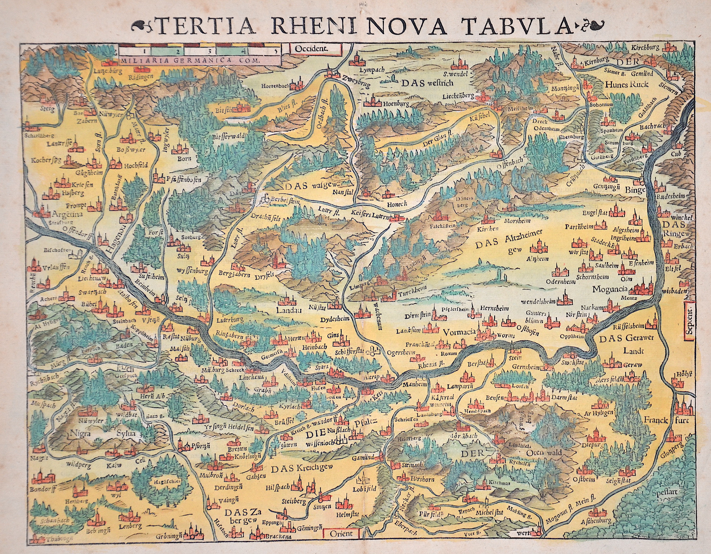
Tertia Rheni Nova Tabula.

| Article ID | EUD792 |
Title | Tertia Rheni Nova Tabula. |
Description | Map shows the course of the Rhine through Rhineland-Palatinate, Baden-Wuerttemberg and Hesse from Strasbourg (Argetina) to Bacharach. The map is oriented to the west. |
| Year | ca. 1550 |
Artist | Münster (1489-1552) |
Sebastian Münsters (1489-1552) is one of the famous cosmographers of the Renaissance. Its real importance in the field of cartography is based on its famous cosmography, which he published in 1544 with 24 double-sided maps (including Moscow and Transylvania). The material for this came largely from research and the collection of information from around 1528, which he initially only wanted to use for a description of Germany, but was now sufficient for a map of the entire world and ultimately led to a cosmography. He constantly tried to improve this work, i.e. to replace or add to maps. In the edition of 1550, only 14 maps were taken over from the earlier editions. The 52 maps printed in the text were also only partially based on the old maps. The great success of this cosmography was also based on the precise work of the woodcuts mostly by Hans Holbein the Younger, Urs Graf, Hans Rudolph Deutsch and David Kandel. It was the first scientific and at the same time generally understandable description of the knowledge of the world in German, in which the basics of history and geography, astronomy and natural sciences, regional and folklore were summarized according to the state of knowledge at that time. Cosmography is the science of describing the earth and the universe. Until the late Middle Ages, geography, geology and astronomy were also part of it. The first edition of the Cosmographia took place in 1544 in German, printed in Heinrich Petri's office in Basel. Heinrich Petri was a son from the first marriage of Münster's wife to the Basel printer Adam Petri. Over half of all editions up to 1628 were also published in German. However, the work has also been published in Latin, French, Czech and Italian. The English editions all comprised only a part of the complete work. Viktor Hantzsch identified a total of 46 editions in 1898 (German 27; Latin 8; French 3; Italian 3; Czech 1) that appeared from 1544 to 1650, while Karl Heinz Burmeister only had 36 (German 21; Latin 5; French 6; Italian 3; Czech 1) that appeared between 1544 and 1628. The first edition from 1544 was followed by the second edition in 1545, the third in 1546, the fourth edition in 1548 and the fifth edition in 1550, each supplemented by new reports and details, text images, city views and maps and revised altogether. Little has been known about who - apart from the book printers Heinrich Petri and Sebastian Henricpetri - were responsible for the new editions after Münster's death. The 1628 edition was edited and expanded by the Basel theologian Wolfgang Meyer. With Cosmographia, Sebastian Münster has published for the first time a joint work by learned historians and artists, by publishers, wood cutters and engravers. The numerous vedute are usually made as woodcuts. Sebastian Münster obtained his knowledge from the travel reports and stories of various scholars, geographers, cartographers and sea travelers. Long after his death, "Kosmographie" was still a popular work with large editions: 27 German, 8 Latin, 3 French, 4 English and even 1 Czech editions appeared. The last edition appeared in Basel in 1650. | |
Historical Description | The Rhine is one of the most important rivers in Europe and has played a significant role in the history and development of the region. It connects several countries, including Switzerland, Germany, France, and the Netherlands. In ancient Europe, the Rhine was an important border, separating the Roman Empire from the Germanic tribes to the north. The Romans used the Rhine as a trade and transport route and built several fortresses along the river to secure their border, including the well-known Limes (border fortifications). The Rhine played a central role in the spread of Roman culture and civilization in the areas along the river. In the Middle Ages, the Rhine was not only an important trade route but also a strategic political point. Cities like Cologne, Mainz, and Speyer along the Rhine developed into important commercial centers. The river was a central part of the Holy Roman Empire and played a key role in the political power dynamics of the region. In the late 18th and early 19th centuries, the Rhine underwent profound changes. During the French Revolution and the Napoleonic Wars, the Rhineland came under French control, and after Napoleon's downfall, it was controlled by Prussia and other German states, becoming an important part of the newly formed German Confederation. In the 19th century, the Rhine experienced significant economic transformation. With the expansion of the railway network and industrialization, the river became an important trade route for raw materials such as coal and iron. Cities like Düsseldorf, Leverkusen, and Mannheim experienced enormous growth and became industrial centers that directly benefited from access to the Rhine. Thus, the course of the Rhine has not only geographical significance but also a profound political, cultural, and economic impact that spans thousands of years. It has shaped both conflict and cooperation and remains a key resource for the countries through which it flows. |
| Place of Publication | Basle |
| Dimensions (cm) | 27 x 34 cm |
| Condition | Perfect condition |
| Coloring | original colored |
| Technique | Woodcut |
Reproduction:
66.00 €
( A reproduction can be ordered individually on request. )