

Adina Sommer
Antique and Contemporary Art
Winzerer Str. 154
80797 München
telephone
+49 89 304714
business hours:
by appointment
Email
![]()


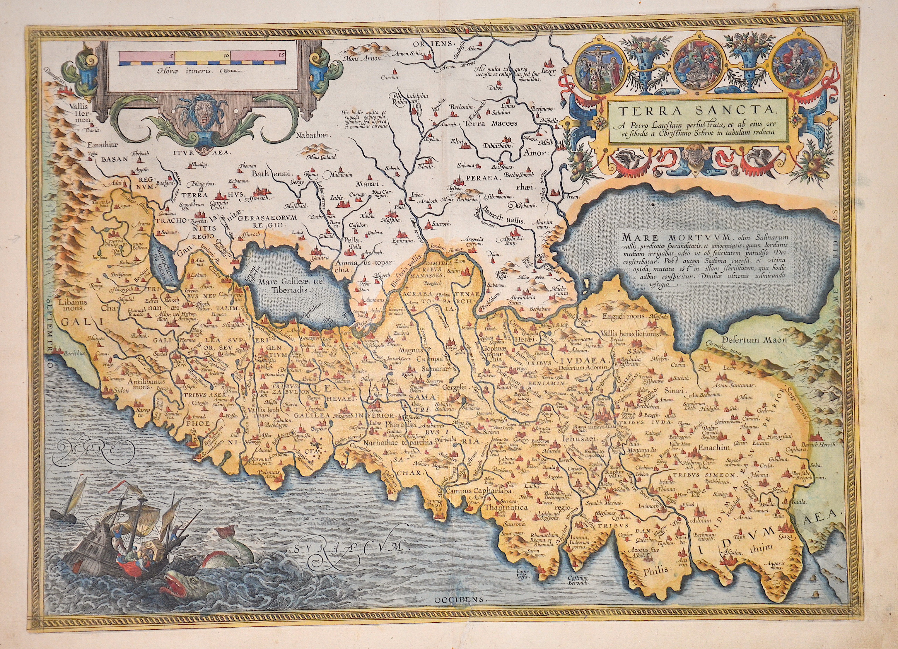
Terra Sancta a petro Laictain perlus trata et ab eius ore et schedis a Christiano schrot in tabulam redacta

| Article ID | ASP0563 |
Title | Terra Sancta a petro Laictain perlus trata et ab eius ore et schedis a Christiano schrot in tabulam redacta |
Description | The map shows the entire Holy Land (Terra Sancta) with a magnificent ship staffage and the scene of Jonah being thrown to the whale. There is also a mileage cartouche and a title cartouche with three different depictions of biblical scenes with Jesus. Latin text on the reverse, p. 97. This map is based on the 9-sheet map of Palestine by Christian Schrot (1570) and was designed according to sources by the Dutch astronomer Petrus Laiksteen, which he had collected on his travels to the Holy Land. |
| Year | ca. 1612 |
Artist | Vrients/Ortelius (1552-1612) |
After 1600, Jan Baptist Vrients acquired the inventory and the plates of Ortelius' Theatrum. In 1603, he published his first atlas of the Netherlands, which was compiled from the sheets of the Theatrum. In 1608, he added 8 new maps to the atlas, including the Inferioris Germaniae Provinciarum. When Vrients died in 1612, the entire stock of maps and engravings was sold to the Moretus brothers from the House of Plantin, who published three further editions (Latin, Italian, Spanish) of the Theatrum. | |
Historical Description | The first archaeologically proven traces of an early or proto-Israelite settlement in the Mashrek region go back to the period between the 12th and 11th centuries BC. BC back. According to biblical tradition, Jerusalem was founded around 1000 BC. Conquered by David from the Jebusites and chosen as the capital of his great empire. The country subsequently became part of the Persian Empire, then the Empire of Alexander the Great, and finally the Empire of the Seleucids. The Maccabees revolt in 165 BC BC brought Israel once more state independence for about 100 years. 63 BC The time of Roman supremacy began. The Romans divided the area into two provinces: Syria in the north, Judea in the south. In the course of the Islamic expansion, the area came under Arab rule in 636. Since then, Palestine has been predominantly inhabited by Arabs. The crusaders ruled from 1099 to 1291 what they called the "Latin Kingdom of Jerusalem". This was followed by the Mamluks from 1291 to 1517 and then the Ottoman rule from 1517 to 1918. None of these authorities had planned their own administration for Palestine or viewed the area as an independent geographical unit. The region was also part of Syria for the Ottomans, probably going back to the Roman name Syria. |
| Place of Publication | Antwerp |
| Dimensions (cm) | 37 x 50,5 cm |
| Condition | Some restoration at lower centerfold |
| Coloring | original colored |
| Technique | Copper print |