

Adina Sommer
Antique and Contemporary Art
Winzerer Str. 154
80797 München
telephone
+49 89 304714
business hours:
by appointment
Email
![]()


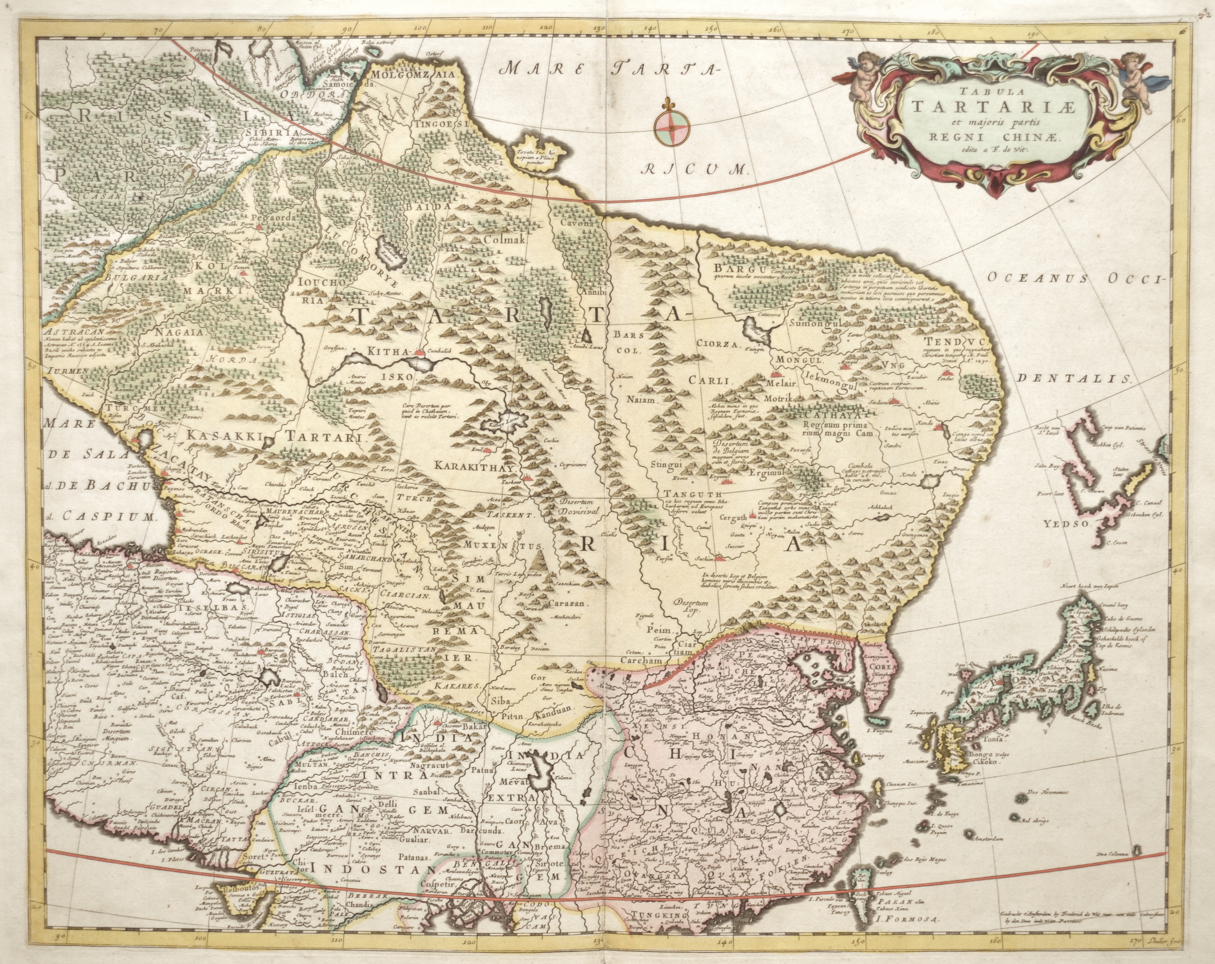
Tabula Tartariae et majoris partis Regni Chinae.

| Article ID | ASC1229 |
Title | Tabula Tartariae et majoris partis Regni Chinae. |
Description | Map shows Tartaria ( notheeast of Russia), total China, Japan and partly India with a decorative title cartouche. |
| Year | ca. 1670 |
Artist | Wit, de (1610-1698) |
Frederik de Wit (1610 – 1698). His Atlas began to appear around 1662 and by 1671 included anywhere from 17 to 151 maps each. In the 1690s he began to use a new title page "Atlas Maior" but continued to use his old title page. His atlas of the Low Countries first published in 1667,was named Nieuw Kaertboeck van de XVII Nederlandse Provinciën and contained 14 to 25 maps. Frederik de Wit quickly expanded upon his first small folio atlas which contained mostly maps printed from plates that he had acquired, to an atlas with 27 maps engraved by or for him. By 1671 he was publishing a large folio atlas with as many as 100 maps. Smaller atlases of 17 or 27 or 51 maps could still be purchased and by the mid-1670s an atlas of as many as 151 maps and charts could be purchased from his shop. In ca.1675 Frederik de Wit released a new nautical atlas. The charts in this atlas replaced the earlier charts from 1664 that are known today in only four bound examples and a few loose copies. Frederik de Wit new charts were sold in a chart book and as part of his atlases. Frederik de Wit published no fewer than 158 land maps and 43 charts on separate folio sheets. In 1695 Frederik de Wit began to publish a town atlas of the Netherlands after he acquired a large number of city plans at the auction of the famous Blaeu publishing firm’s printing plates. Dating Frederik de Wit atlases is considered difficult because usually no dates were recorded on the maps and their dates of publication extended over many years. | |
Historical Description | By the 15th century, Beijing had essentially taken its current shape. The Ming city wall continued to serve until modern times, when it was pulled down and the 2nd Ring Road was built in its place. It is generally believed that Beijing was the largest city in the world for most of the 15th, 16th, 17th, and 18th centuries.The first known church was constructed by Catholics in 1652 at the former site of Matteo Ricci's chapel; the modern Nantang Cathedral was later built upon the same site. The capture of Beijing by Li Zicheng's peasant army in 1644 ended the dynasty, but he and his Shun court abandoned the city without a fight when the Manchu army of Prince Dorgon arrived 40 days later. The Forbidden City was the Chinese imperial palace from the Ming dynasty to the end of the Qing dynasty( the years 1420 to 1912). It is located in the center of Beijing, China, and now houses the Palace Museum. When Hongwu Emperor's son Zhu Di became the Yongle Emperor, he moved the capital from Nanjing to Beijing, and construction began in 1406 on what would become the Forbidden City. Construction lasted 14 years and required more than a million workers. It served as the home of emperors and their households as well as the ceremonial and political center of Chinese government for almost 500 years. The palace complex exemplifies traditional Chinese palatial architecture, and has influenced cultural and architectural developments in East Asia and elsewhere. Since 1925 the Forbidden City has been under the charge of the Palace Museum, whose extensive collection of artwork and artifacts were built upon the imperial collections of the Ming and Qing dynasties. |
| Place of Publication | Amsterdam |
| Dimensions (cm) | 43,5 x 54,5 cm |
| Condition | Some restoration at lower centerfold |
| Coloring | original colored |
| Technique | Copper print |