

Adina Sommer
Antique and Contemporary Art
Winzerer Str. 154
80797 München
telephone
+49 89 304714
business hours:
by appointment
Email
![]()


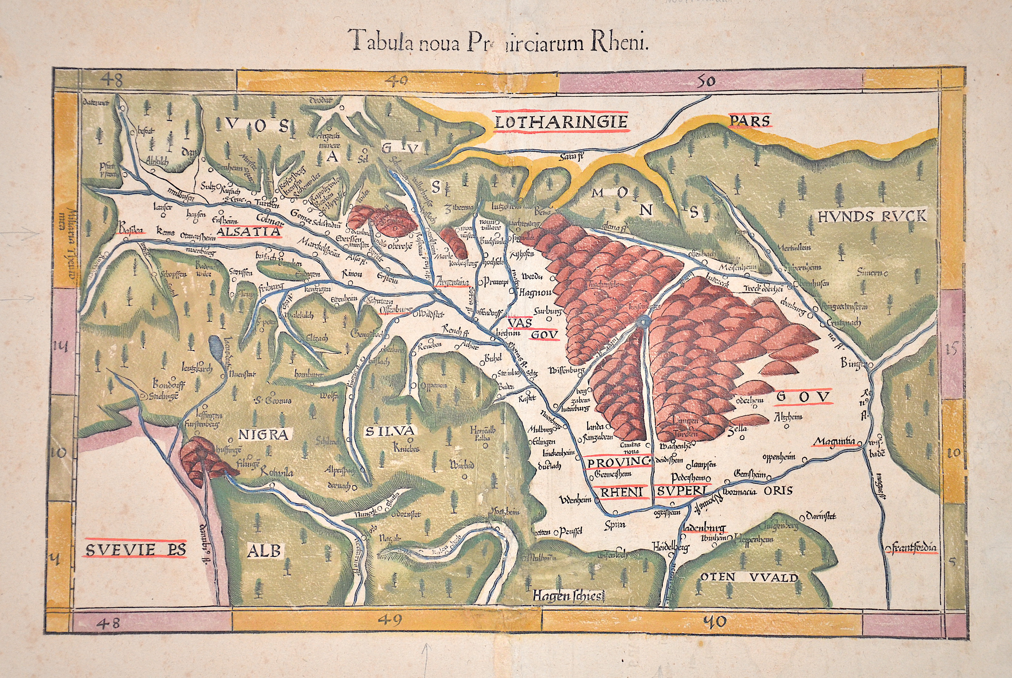
Tabula Noua Prouinciarum Rheni.

| Article ID | EUD2673 |
Title | Tabula Noua Prouinciarum Rheni. |
Description | Map shows the course of the Rhine from Bingen via Mainz (Maguntia), Oppenheim, Worms, Speyer, Heidelberg, Strasbourg (Argentina), Breisach, Ottmarsheim, Kembs to Basel. The map is oriented to the west. The reverse shows a map of Lorraine on 1/2 page. After Martin Waldseemüller, printed by Gaspar Trechsel. |
| Year | ca. 1541 |
Artist | Ptolemy/ Fries (1490-1531) |
Lorenz (Laurent) Fries was born in Alsace in 1490 or thereabouts, describing himself on one occasion as from Colmar, one of the towns of the region. He studied medicine at university, or rather at universities, as he seems to have had a peripatetic education, apparently spending time at the universities of Pavia, Piacenza, Montpellier and Vienna. Having successfully completed his education, Fries established himself as a physician, at a succession of places in the Alsace region, with a short spell in Switzerland, before settling in Strasbourg, in about 1519. By this time, he had established a reputation as a writer on medical topics, with several publications already to his credit. Indeed, it was thus that Fries met the Strasbourg printer and publisher Johann Grüninger, an associate of the St. Die group of scholars formed by, among others, Walter Lud, Martin Ringmann and Martin Waldseemuller. Gruninger was responsible for printing several of the maps prepared by Waldseemuller, and for supervising the cutting of the maps for the 1513 edition of Ptolemy, edited by the group. This meeting was to introduce a important digression into Fries' life, and for the next five years, from about 1520 to about 1525, he worked in some capacity as a cartographic editor with Gruninger, exploiting the corpus of material that Waldseemuller had created. Claudius Ptolemy ( arround 100- 160 a.C.) Geographia, gives a list of geographic coordinates of spherical longitude and latitude of almost ten thousand point locations on the earth surface, as they were known at his times. The list is organized in Tabulae which cor- respond to specific regions of the three known continents at that time, Africa, Asia and Europe. Research on Ptolemy’s Geographia has started at the University of Thessaloniki, Greece, in the eighties, focused mainly, but not exclusively, on data re- lated to territories which are now under the sovereignty of the modern Greek state. The World of Ptolemy is classified in Regions, since each Chapter is referred to one of them, giving by this way the concept of Atlas as it is understood today. | |
Historical Description | The Rhine is one of the most important rivers in Europe and has played a significant role in the history and development of the region. It connects several countries, including Switzerland, Germany, France, and the Netherlands. In ancient Europe, the Rhine was an important border, separating the Roman Empire from the Germanic tribes to the north. The Romans used the Rhine as a trade and transport route and built several fortresses along the river to secure their border, including the well-known Limes (border fortifications). The Rhine played a central role in the spread of Roman culture and civilization in the areas along the river. In the Middle Ages, the Rhine was not only an important trade route but also a strategic political point. Cities like Cologne, Mainz, and Speyer along the Rhine developed into important commercial centers. The river was a central part of the Holy Roman Empire and played a key role in the political power dynamics of the region. In the late 18th and early 19th centuries, the Rhine underwent profound changes. During the French Revolution and the Napoleonic Wars, the Rhineland came under French control, and after Napoleon's downfall, it was controlled by Prussia and other German states, becoming an important part of the newly formed German Confederation. In the 19th century, the Rhine experienced significant economic transformation. With the expansion of the railway network and industrialization, the river became an important trade route for raw materials such as coal and iron. Cities like Düsseldorf, Leverkusen, and Mannheim experienced enormous growth and became industrial centers that directly benefited from access to the Rhine. Thus, the course of the Rhine has not only geographical significance but also a profound political, cultural, and economic impact that spans thousands of years. It has shaped both conflict and cooperation and remains a key resource for the countries through which it flows. |
| Place of Publication | Lyon |
| Dimensions (cm) | 28 x 43 cm |
| Condition | Wormholes perfectly restored |
| Coloring | original colored |
| Technique | Woodcut |