

Adina Sommer
Antique and Contemporary Art
Winzerer Str. 154
80797 München
telephone
+49 89 304714
business hours:
by appointment
Email
![]()


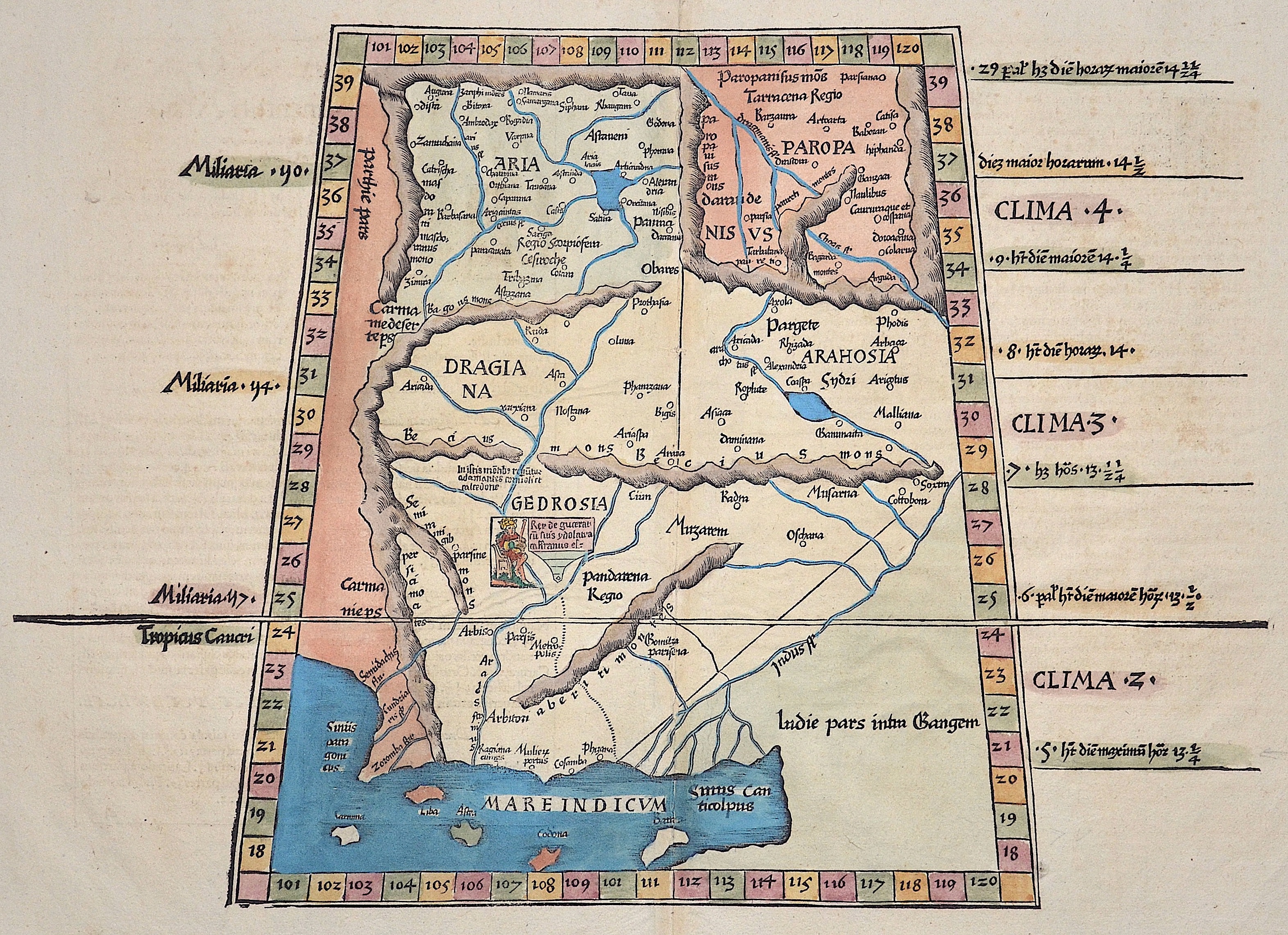
Tabula nona Asiae continetur, aria…..

| Article ID | ASI0685 |
Title | Tabula nona Asiae continetur, aria….. |
Description | Map showing Pakistan, north-eastern India and the Ganges, from "Claudii Ptolemaei Alexandrini geographicae enarrationis libri octo". Edition of Ptolemy’s “Geographia”, published by Michael Servetus, known as Villanovanus, based on the 1522 edition by Laurent Fries, which in turn reproduces the famous 1513 edition by Waldseemüller. The maps from that edition are reproduced here in reduced form, though with significant differences in the title, marginal text and on the reverse. |
| Year | ca. 1522 |
Artist | Ptolemy/ Fries (1490-1531) |
Lorenz (Laurent) Fries was born in Alsace in 1490 or thereabouts, describing himself on one occasion as from Colmar, one of the towns of the region. He studied medicine at university, or rather at universities, as he seems to have had a peripatetic education, apparently spending time at the universities of Pavia, Piacenza, Montpellier and Vienna. Having successfully completed his education, Fries established himself as a physician, at a succession of places in the Alsace region, with a short spell in Switzerland, before settling in Strasbourg, in about 1519. By this time, he had established a reputation as a writer on medical topics, with several publications already to his credit. Indeed, it was thus that Fries met the Strasbourg printer and publisher Johann Grüninger, an associate of the St. Die group of scholars formed by, among others, Walter Lud, Martin Ringmann and Martin Waldseemuller. Gruninger was responsible for printing several of the maps prepared by Waldseemuller, and for supervising the cutting of the maps for the 1513 edition of Ptolemy, edited by the group. This meeting was to introduce a important digression into Fries' life, and for the next five years, from about 1520 to about 1525, he worked in some capacity as a cartographic editor with Gruninger, exploiting the corpus of material that Waldseemuller had created. The first edition of Ptolemy's Geographia editet by Fries was published in Strasbourg in 1522, with maps that were copied and re-engraved from those of Martin Waldseemüller of the 1520 edition of Ptolemy and text edited by Pirckheimer. In 1525 a second edition was printed in Strasbourg. At the death of Fries and Gruninger, the plates were purchased by the brother Melchior and Gaspar Treschel, who printed a thord edition in Lyon in 1535. For the text, the two editors used the supervision of Michael Servetus, who editet Pirckheimer's text. Finally, in 1541, Gaspare Treechsel published in Vienne, in the Dauphine, this fourth edition, again with Servetus' text. in this edition, compared to the first edition of Strasbourg in 1522, the text underwent numerous changes, corrections and additions, but the wood-Blocks were not changed. Claudius Ptolemy ( arround 100- 160 a.C.) Geographia, gives a list of geographic coordinates of spherical longitude and latitude of almost ten thousand point locations on the earth surface, as they were known at his times. The list is organized in Tabulae which cor- respond to specific regions of the three known continents at that time, Africa, Asia and Europe. Research on Ptolemy’s Geographia has started at the University of Thessaloniki, Greece, in the eighties, focused mainly, but not exclusively, on data re- lated to territories which are now under the sovereignty of the modern Greek state. The World of Ptolemy is classified in Regions, since each Chapter is referred to one of them, giving by this way the concept of Atlas as it is understood today. | |
Historical Description | Around the middle of the 2nd millennium BC The Aryans from Central Asia invaded Pakistan. They shaped Vedic culture and Hinduism. Today's Pakistani territory already came into contact with Islam in the early 8th century when the Arabs conquered the Indus Valley under Muhammad ibn al-Qasim in 712. For centuries the border between the Islamic world and the Indian culture was east of the Indus. The Punjab initially remained outside the Muslim sphere of influence. It was only around 1000 that the Turkish Ghaznavid dynasty extended its empire to the whole of Pakistan and parts of northern India. Until the beginning of the 19th century, Pakistan was part of various Islamic empires, including those of the Persian Ghurids (12th and 13th centuries), the North Indian Delhi Sultans (13th and 14th centuries) and Mughals (16th to 18th centuries) ) and the Afghan Durrani dynasty (18th and 19th centuries). |
| Place of Publication | Vienna |
| Dimensions (cm) | 30 x 43 cm |
| Condition | Perfect condition |
| Coloring | original colored |
| Technique | Woodcut |