

Adina Sommer
Antique and Contemporary Art
Winzerer Str. 154
80797 München
telephone
+49 89 304714
business hours:
by appointment
Email
![]()


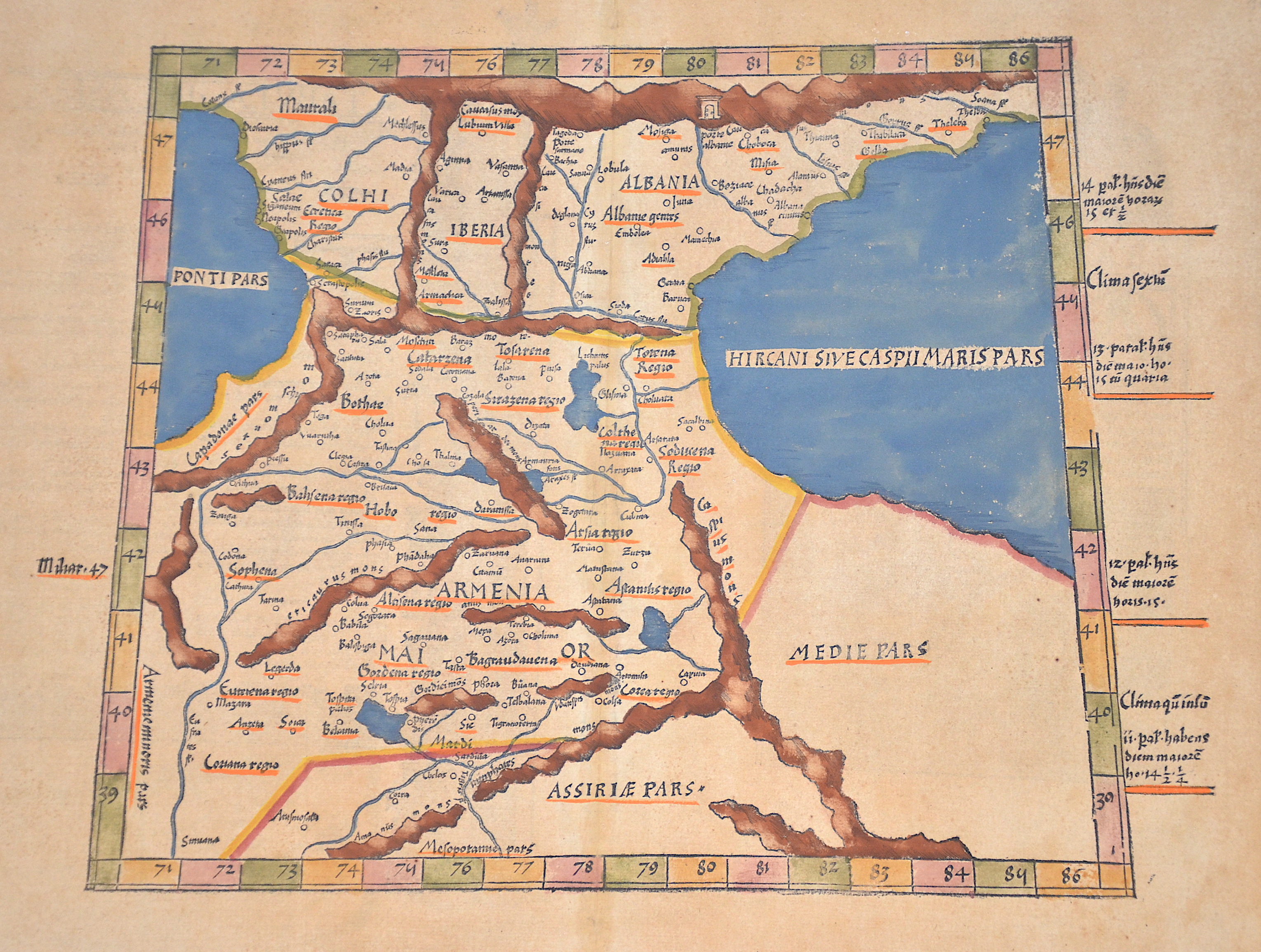
Tabula III Asiae

| Article ID | AST083 |
Title | Tabula III Asiae |
Description | Map shows the Caucasus with the Caspian and Black Seas, on the reverse a view of the country and its people with description and ornamental decorations. |
| Year | ca. 1530 |
Artist | Ptolemy/ Fries (1490-1531) |
Lorenz (Laurent) Fries was born in Alsace in 1490 or thereabouts, describing himself on one occasion as from Colmar, one of the towns of the region. He studied medicine at university, or rather at universities, as he seems to have had a peripatetic education, apparently spending time at the universities of Pavia, Piacenza, Montpellier and Vienna. Having successfully completed his education, Fries established himself as a physician, at a succession of places in the Alsace region, with a short spell in Switzerland, before settling in Strasbourg, in about 1519. By this time, he had established a reputation as a writer on medical topics, with several publications already to his credit. Indeed, it was thus that Fries met the Strasbourg printer and publisher Johann Grüninger, an associate of the St. Die group of scholars formed by, among others, Walter Lud, Martin Ringmann and Martin Waldseemuller. Gruninger was responsible for printing several of the maps prepared by Waldseemuller, and for supervising the cutting of the maps for the 1513 edition of Ptolemy, edited by the group. This meeting was to introduce a important digression into Fries' life, and for the next five years, from about 1520 to about 1525, he worked in some capacity as a cartographic editor with Gruninger, exploiting the corpus of material that Waldseemuller had created. The first edition of Ptolemy's Geographia editet by Fries was published in Strasbourg in 1522, with maps that were copied and re-engraved from those of Martin Waldseemüller of the 1520 edition of Ptolemy and text edited by Pirckheimer. In 1525 a second edition was printed in Strasbourg. At the death of Fries and Gruninger, the plates were purchased by the brother Melchior and Gaspar Treschel, who printed a thord edition in Lyon in 1535. For the text, the two editors used the supervision of Michael Servetus, who editet Pirckheimer's text. Finally, in 1541, Gaspare Treechsel published in Vienne, in the Dauphine, this fourth edition, again with Servetus' text. in this edition, compared to the first edition of Strasbourg in 1522, the text underwent numerous changes, corrections and additions, but the wood-Blocks were not changed. Claudius Ptolemy ( arround 100- 160 a.C.) Geographia, gives a list of geographic coordinates of spherical longitude and latitude of almost ten thousand point locations on the earth surface, as they were known at his times. The list is organized in Tabulae which cor- respond to specific regions of the three known continents at that time, Africa, Asia and Europe. Research on Ptolemy’s Geographia has started at the University of Thessaloniki, Greece, in the eighties, focused mainly, but not exclusively, on data re- lated to territories which are now under the sovereignty of the modern Greek state. The World of Ptolemy is classified in Regions, since each Chapter is referred to one of them, giving by this way the concept of Atlas as it is understood today. | |
Historical Description | Armenia is one of the oldest countries in the world, with a rich and complex history that dates back several millennia. As early as the 7th century, Christian Byzantines and Muslim Arabs competed for control of the region. In 1045, the Byzantines ended the Armenian kingdom by occupying Ani. In 1064, the Seljuks conquered Armenia, followed by the Mongols in the 13th century. In 1555, the country was divided between Persia and the Ottoman Empire, and again in 1639, when the Safavids gained control of roughly what is today the modern Armenian state, while the Turks retained the larger western part. In the Russo-Persian War, Persia lost the province of Armenia to the Russian Empire in 1828. During World War I, countless Armenians in the Ottoman Empire were systematically exterminated during the Armenian Genocide, and the Armenian settlement area shrank significantly. Since then, the territory of the Republic of Armenia comprises only the northeastern part of what was once a much larger Armenian homeland—a region that, throughout its eventful history, rarely formed a unified state. The border between Turkey and the Russian sphere of influence was established in 1922. The Armenian Soviet Socialist Republic, which was part of the Soviet Union, gained independence in 1991 with the collapse of the USSR. The areas west of modern Armenia remained lost to the Armenian state. |
| Place of Publication | Lyon |
| Dimensions (cm) | 30,3 x 42 cm |
| Condition | Some browning |
| Coloring | colored |
| Technique | Woodcut |