

Adina Sommer
Antique and Contemporary Art
Winzerer Str. 154
80797 München
telephone
+49 89 304714
business hours:
by appointment
Email
![]()


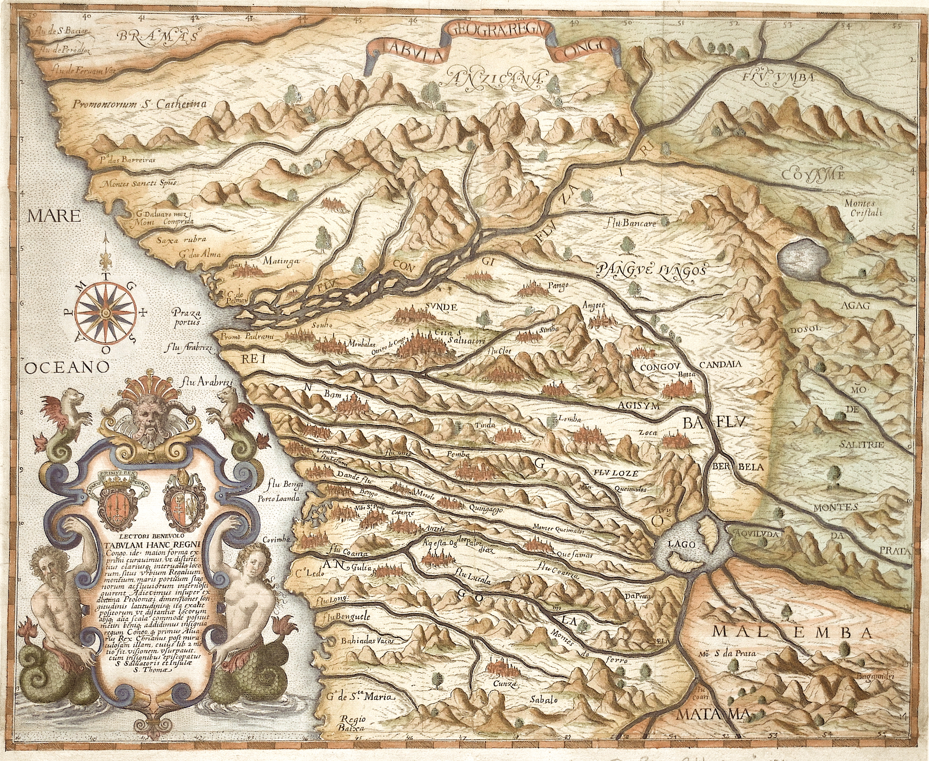
Tabula Geogra: Regni Congo / Lectori Benevolo Tabulam Hanc Regni Congo..

| Article ID | AF0454 |
Title | Tabula Geogra: Regni Congo / Lectori Benevolo Tabulam Hanc Regni Congo.. |
Description | Map shows the African Republic of the Congo (Democratic Republic of the Congo) with part of the Congo River as far as the mouth of the Atlantic. The map shows rivers, mountains, forests and cities in detail. With a magnificent cartouche, two coats of arms and a wind rose. From Dietrich de Brys "Petit Voyages". Pigafetta's map of Africa, based on the explorations of Duarte Lopes, a Portuguese whose journeys into the Congo Basin heightened speculation about the source of the Nile. The map shows the part of the Congo region that Duarte Lopes visited between 1578 and 1584 during his travels in Africa. The viewer notices the accuracy of the coastline, as well as the density of place names and geographic features filling the interior of the continent. Although not all are based on strict facts, this was the most detailed and certainly the most accurate map of Africa for the Congo region published up to that time. |
| Year | ca. 1597 |
Artist | Bry, de - Pigafetta (1533-1600) |
Filippo Pigafetta of Vicenza (c. 1533 – after 1600) was a translator, scholar, and travel writer. He became known for publishing the book "Relatione del Reame di Congo" (1591), which was based on the reports of the Portuguese explorer Duarte Lopes. This work was one of the earliest systematic descriptions of the Kingdom of Kongo (Central Africa) from a European perspective. Pigafetta combined travel accounts with geographical and cultural observations – though filtered through a European and Christian worldview. - - Theodorus de Bry (1528-1598) Frankfurt a.M. Around 1570, Theodorus de Bry, a Protestant, fled religious persecution south to Strasbourg, along the west bank of the Rhine. In 1577, he moved to Antwerp in the Duchy of Brabant, which was part of the Spanish Netherlands or Southern Netherlands and Low Countries of that time (16th Century), where he further developed and used his skills as a copper engraver. Between 1585 and 1588 he lived in London, where he met the geographer Richard Hakluyt and began to collect stories and illustrations of various European explorations, most notably from Jacques Le Moyne de Morgues. Depiction of Spanish atrocities in the New World, as recounted by Bartolome de las Casas in Narratio Regionum indicarum per Hispanos Quosdam devastatarum verissima. In 1588, Theodorus and his family moved permanently to Frankfurt-am-Main, where he became citizen and began to plan his first publications. The most famous one is known as Les Grands Voyages, i.e., The Great Travels, or The Discovery of America. He also published the largely identical India Orientalis-series, as well as many other illustrated works on a wide range of subjects. His books were published in Latin, and were also translated into German, English and French to reach a wider reading public. The two collections of travelogues published by Theodor de Bry in Frankfurt are among the most important of the early modern period and established his reputation for posterity: He created The Arrival of Columbus in the New World in 1594. The West Indian Voyages (ed. 1590-1618) chronicled the discovery and conquest of the Americas by Europeans, while the East Indian Voyages followed the rise of Holland as a trading power in Asia around 1600. Both series appeared in German and Latin, were intended for a European audience, and were richly illustrated with copper engravings. Theodor de Bry was only able to publish six parts of his complete works. After his death, his sons Johann Theodor and Johann Israel and then Johann Theodor's son-in-law Matthäus Merian continued the work until 1634. In the end, it contained 25 parts and over 1500 copper engravings. The brothers were succeeded as engravers and publishers by Sebastian Furck. | |
Historical Description | The indigenous population of today's state consisted of pygmies, who are now only a small minority. Bantu peoples immigrated for centuries. Among the states there, the Kingdom of the Congo, founded in the 14th century and one of the largest African states ever, emerged. In the 15th century, Portuguese sailors around Diogo Cão explored the area of the Congo estuary and established diplomatic relations with the Congo Empire in 1491. From the 16th century onwards, the Congo Empire was in decline. By the end of the 17th century, the kingdom was completely destroyed, as well as being exploited and looted by slave hunters. After this collapse, the Portuguese supremacy was replaced by that of the Dutch and British. At the beginning of the 18th century the Congo Empire had almost completely disintegrated. In 1866 the last Portuguese left. In the 1870s, Henry Morton Stanley from Welsh was the first European to travel to the hinterland. He proposed that the Congo be incorporated into the British colonial empire. The British government refused because it was primarily interested in the sources of the Nile. The Democratic Republic of the Congo was originally administered as the Belgian Congo by a legislative assembly and regional assemblies made up of only Europeans appointed by colonial authorities. By the late 1950s there was a greater turnout of Africans, but not full voting rights until independence when the colony was renamed Zaire. With the global striving for independence in the colonies, the pressure for state self-determination also grew in the Congo. After the first unrest in the capital Léopoldville and under pressure from the global public, Belgium suddenly withdrew from the Congo in early 1959, leaving behind a chaos. In 1960 the Congo gained independence. |
| Place of Publication | Frankfurt on Main |
| Dimensions (cm) | 30,5 x 37,5 cm |
| Condition | Margin replaced with lower missing part |
| Coloring | original colored |
| Technique | Copper print |