

- Alsace
- Aquitaine
- Auvergne
- Bourgogne
- Bourgogne-Franche-Comte
- Brittany
- Centre
- Champagne
- France Islands
- Gascogne
- Gironde
- Hauts-de-France
- Ile de France
- Languedoc
- Lothringen
- Midi-Pyrénées
- Nivernais
- Nord-Pas-de-Calais
- Normandie
- Occitanie
- Pas-de-Calais
- Pays de la Loire
- Picardie
- Poitou-Charentes
- Provence-Alpes-Cote d Azur
- Pyrénées
- Rhone- Alpes
- Saintonge
- Savoyen
- Tourain
- Westcoast
Adina Sommer
Antique and Contemporary Art
Winzerer Str. 154
80797 München
telephone
+49 89 304714
business hours:
by appointment
Email
![]()


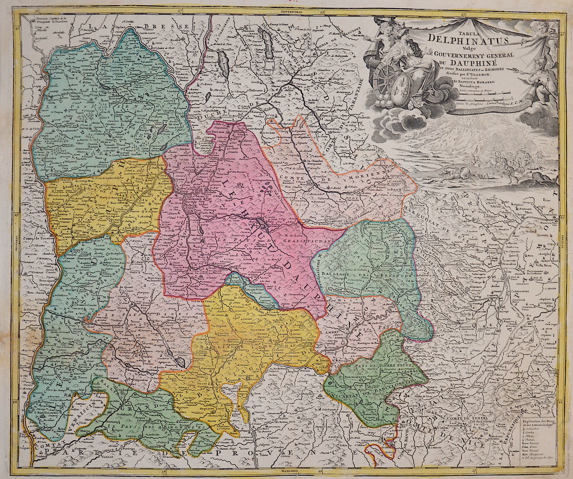
Tabula Delphinatus Vulgo Gouvernement General du Dauphiné

| Article ID | EUF4657 |
Title | Tabula Delphinatus Vulgo Gouvernement General du Dauphiné |
Description | Map shows the historical region of Dauphiné, located in the southeast of France. Furthermore, a magnificent title cartouche at the top right. |
| Year | ca. 1710 |
Artist | Homann (1664-1724) |
Johann Babtiste Homann (1664-1724), Nuremberg, was born in Oberkammlach, the Electorate of Bavaria. Although educated at a Jesuit school, and preparing for an ecclesiastical career, he eventually converted to Protestantism and from 1687 worked as a civil law notary in Nuremberg. He soon turned to engraving and cartography; in 1702 he founded his own publishing house. Homann acquired renown as a leading German cartographer, and in 1715 was appointed Imperial Geographer by Emperor Charles VI. Giving such privileges to individuals was an added right that the Holy Roman Emperor enjoyed. In the same year he was also named a member of the Prussian Academy of Sciences in Berlin. Of particular significance to cartography were the imperial printing privileges (Latin: privilegia impressoria). These protected for a time the authors in all scientific fields such as printers, copper engravers, map makers and publishers. They were also very important as a recommendation for potential customers. In 1716 Homann published his masterpiece Grosser Atlas ueber die ganze Welt (Grand Atlas of all the World). Numerous maps were drawn up in cooperation with the engraver Christoph Weigel the Elder, who also published Siebmachers Wappenbuch. Homann died in Nuremberg. He was succeeded by the Homann heirs company, which was in business until 1848. The company was known as Homann Erben, Homanniani Heredes, or Heritiers de Homann abroad. | |
Historical Description | Auvergne is one of the historical provinces of France. The name of the region is derived from the Arvernians, a Gaulish tribe that settled in the area at the time of the Roman conquest. In late antiquity, Auvergne was conquered by the Visigoths under Eurich in the 70s of the 5th century and was absorbed into the Frankish Empire at the beginning of the 6th century. During the Middle Ages, four dominions emerged in Auvergne. In 1651, the county passed to Frédéric-Maurice de La Tour d'Auvergne, duc de Bouillon, who received Auvergne and Albret in exchange for the strategically much more important Sedan and Raucourt. His descendants were deposed during the French Revolution. In 1790, the historic province was divided into the current departments. The departments of Haute-Loire and Allier also include parts of the historical provinces of Bourbonnais, Lyonnais and Languedoc. |
| Place of Publication | Nuremberg |
| Dimensions (cm) | 48,5 x 58 cm |
| Condition | Restored tear at the center |
| Coloring | original colored |
| Technique | Copper print |