

Adina Sommer
Antique and Contemporary Art
Winzerer Str. 154
80797 München
telephone
+49 89 304714
business hours:
by appointment
Email
![]()


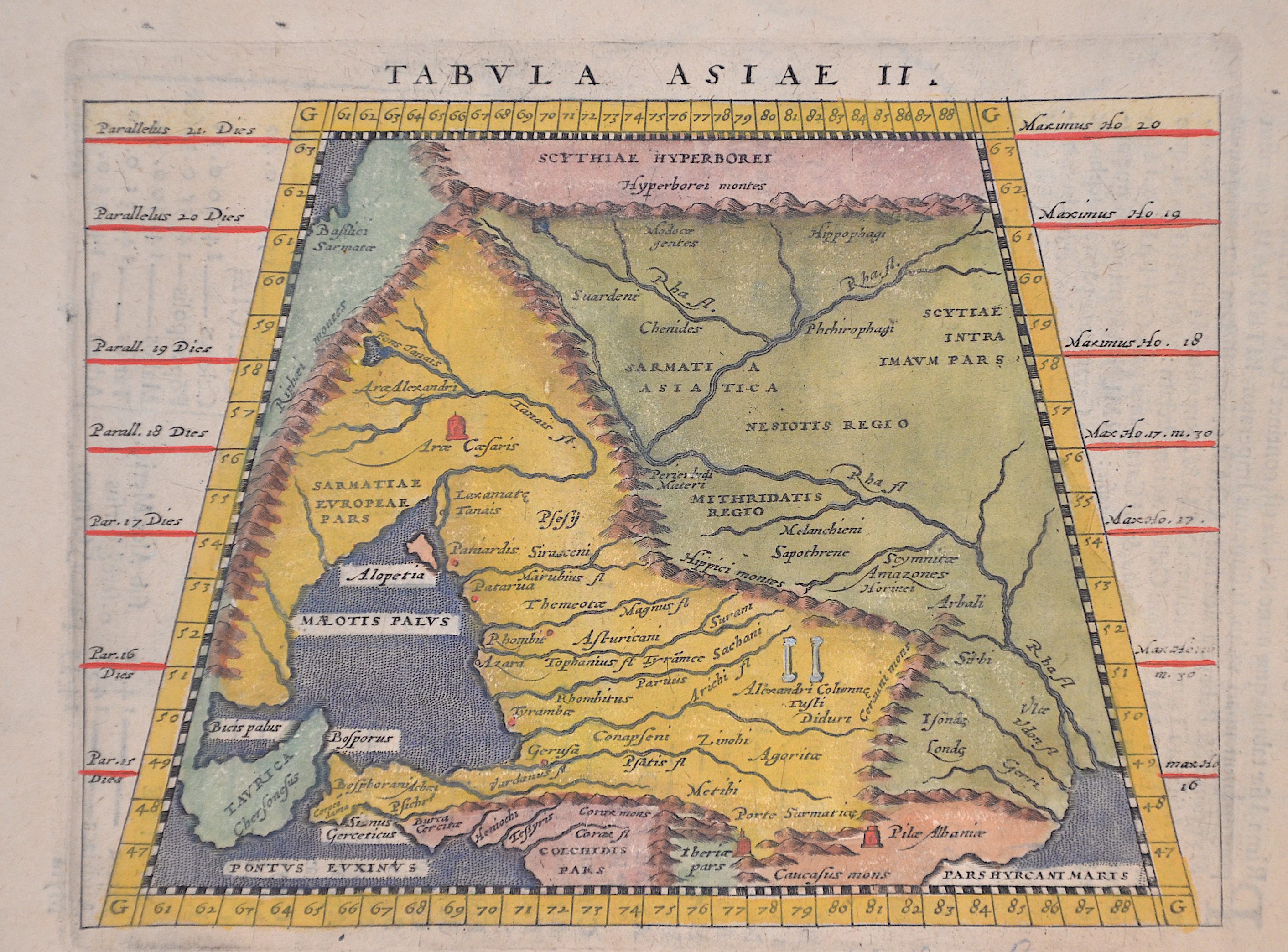
Tabula Asiea II.

| Article ID | ASP0386 |
Title | Tabula Asiea II. |
Description | Interesting map shows in Trapeziod shape former Sarmatia, now partly Russia with the Black Sea, the Ukraine and the peninsula Krim with the Asow sea. Reverse with title "Asiae Tabula I. 17. and a Latin description . |
| Year | ca. 1617 |
Artist | Ptolemy/Giovanni Magini (1555-1617) |
Giovanni Antonio Magini was an italian astronomer, astrologer, cartographer and mathematician. In 1592 he issued "De Planis Triangulis" by describing the Quadrant. Magini also maufactured an atlas of Italy which has been issued by his son in 1620. The moon craterMagnius was named after Magini. Claudius Ptolemy ( arround 100- 160 a.C.) Geographia, gives a list of geographic coordinates of spherical longitude and latitude of almost ten thousand point locations on the earth surface, as they were known at his times. The list is organized in Tabulae which cor- respond to specific regions of the three known continents at that time, Africa, Asia and Europe. Research on Ptolemy’s Geographia has started at the University of Thessaloniki, Greece, in the eighties, focused mainly, but not exclusively, on data re- lated to territories which are now under the sovereignty of the modern Greek state. The World of Ptolemy is classified in Regions, since each Chapter is referred to one of them, giving by this way the concept of Atlas as it is understood today. | |
Historical Description | According to the Nestor Chronicle, Kiev was founded at the beginning of the 6th century by the three brothers Kyj, Shchek and Doriv and their sister Lybid from the tribe of the Poljans. The city had a strategic location on the trade route from the Baltic Sea to the Black Sea. After the Khmelnytskyi Uprising, which began in 1648, Kiev became the capital of the Zaporozhian Cossack Hetmanate. These subordinated themselves to the Moscow tsar in 1654 in the Pereyaslav agreement. Under the rule of Ivan Masepa, a Cossack hetman, many important buildings were renovated and schools were founded. The Kiev Cave Monastery, St. Sophia Cathedral and St. Michael's Monastery received their present appearance in the style of Ukrainian Baroque. The baroque St. Andrew's Church and St. Mary's Palace were built under Empress Elizabeth. Especially Emperor Nicholas I, who affectionately called Kiev Jerusalem of the Russian Earth, did much to develop Kiev into an important trade, transport and industrial center of the Russian Empire. Among other things, he had St. Vladimir University, now the Taras Shevchenko National University of Kiev, founded and initiated the construction of the massive Nicholas Chain Bridge over the Dnieper River. In 1888, the city celebrated with great pomp the 900th anniversary of the Christianization of Rus. The construction of the Vladimir Cathedral in Byzantine style was dedicated to this anniversary. In 1892, Kiev became the first city in the Russian Empire to receive an electric streetcar. |
| Dimensions (cm) | 13 x 17 cm |
| Condition | Perfect condition |
| Coloring | original colored |
| Technique | Copper print |