

Adina Sommer
Antique and Contemporary Art
Winzerer Str. 154
80797 München
telephone
+49 89 304714
business hours:
by appointment
Email
![]()


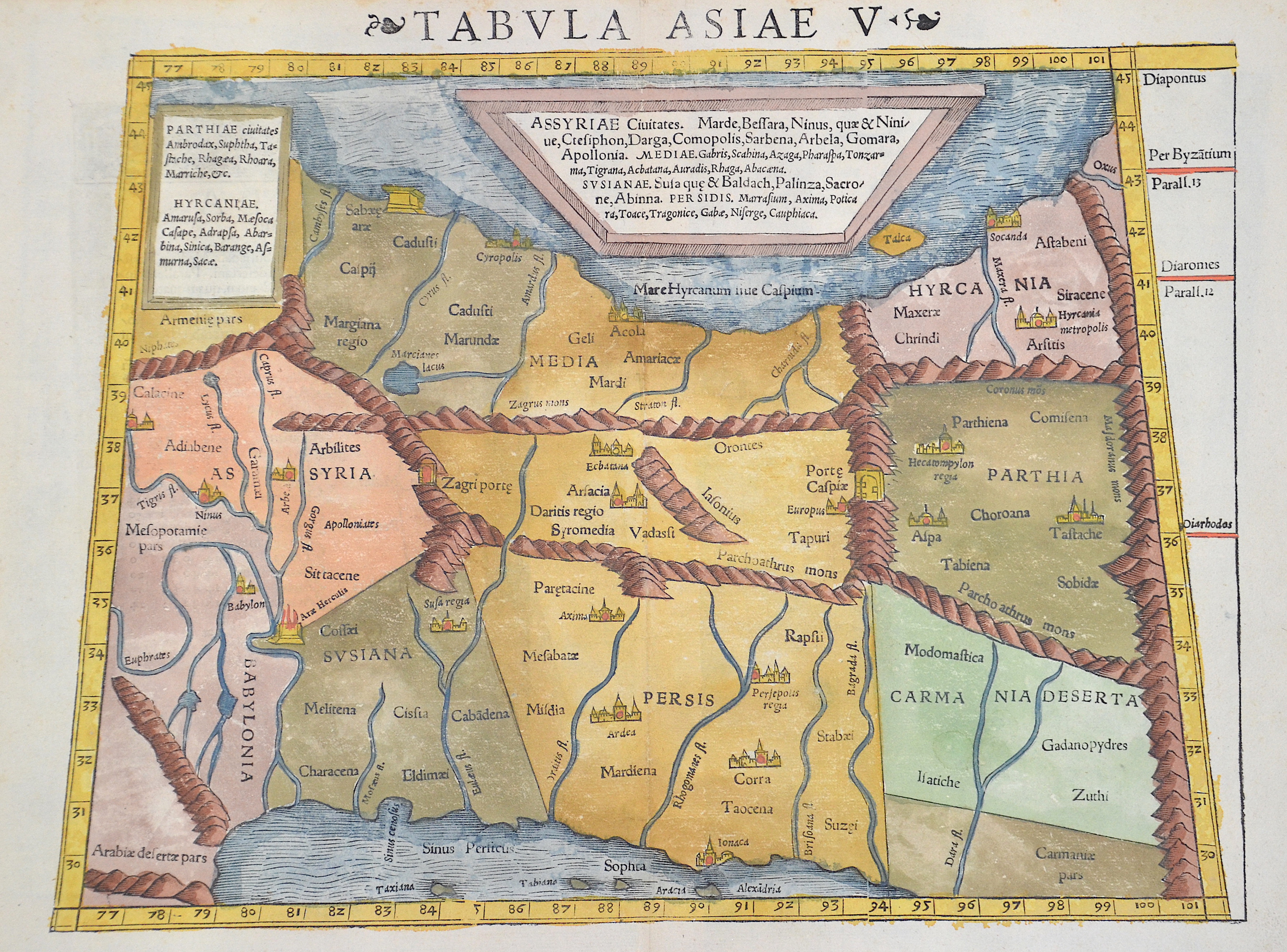
Tabula Asiae V

| Article ID | ASA1314 |
Title | Tabula Asiae V |
Description | Trapezoidal map shows Asia Minor with Persia, the area of the Tigris and Euphrates rivers, the former Mesopotamia. |
| Year | ca. 1552 |
Artist | Ptolemy/Münster Sebastian (1489-1552) |
Sebastian Münster (1489–1552) was a prominent Renaissance cosmographer. His Cosmographia, published in 1544 with 24 double-page maps based on research from around 1528, was continuously expanded. It was the first widely accessible scientific description of the world in German, combining knowledge from history, geography, astronomy, and natural sciences. The work remained popular for a long time and was published in many editions and languages until 1650. Claudius Ptolemy (c. 100–160 AD) was a Greek mathematician, geographer, and astronomer. His works on astronomy, geography, and astrology were long considered standard references. He described the Earth as the center of the universe (Centrum Mundi) and established the basis for latitude measurement. His Geographia included the known world and the hypothesis of Terra Australis. Ptolemy provided written instructions for mapmaking but made only rough sketches himself; later maps were created under his name. | |
Historical Description | The ancient empire of the Persians is referred to as the Persian Empire or Persian Empire, which at times extended from Thrace to north-west India and Egypt. It existed in different dimensions from about 550 to 330 BC. AD (Old Persian Empire of the Achaemenids) and from approx. 224 to 651 AD (New Persian Empire of the Sassanids). This name is a foreign name, as the native name has always been a variant of the term Iran. By the 1500s, Ismail I of Ardabil established the Safavid Empire,with his capital at Tabriz. Beginning with Azerbaijan, he subsequently extended his authority over all of the Iranian territories, and established an intermittent Iranian hegemony over the vast relative regions, reasserting the Iranian identity within large parts of Greater Iran. Iran was predominantly Sunni, but Ismail instigated a forced conversion to the Shia branch of Islam, spreading throughout the Safavid territories in the Caucasus, Iran, Anatolia, and Mesopotamia. As a result, modern-day Iran is the only official Shia nation of the world, with it holding an absolute majority in Iran and the Republic of Azerbaijan, having there the first and the second highest number of Shia inhabitants by population percentage in the world. Meanwhile, the centuries-long geopolitical and ideological rivalry between Safavid Iran and the neighboring Ottoman Empire led to numerous Ottoman–Iranian wars. The Safavid era peaked in the reign of Abbas I (1587–1629), surpassing their Turkish archrivals in strength, and making Iran a leading science and art hub in western Eurasia. The Safavid era saw the start of mass integration from Caucasian populations into new layers of the society of Iran, as well as mass resettlement of them within the heartlands of Iran, playing a pivotal role in the history of Iran for centuries onwards. Following a gradual decline in the late 1600s and the early 1700s, which was caused by internal conflicts, the continuous wars with the Ottomans, and the foreign interference (most notably the Russian interference), the Safavid rule was ended by the Pashtun rebels who besieged Isfahan and defeated Sultan Husayn in 1722. In 1729, Nader Shah, a chieftain and military genius from Khorasan, successfully drove out and conquered the Pashtun invaders. He subsequently took back the annexed Caucasian territories which were divided among the Ottoman and Russian authorities by the ongoing chaos in Iran. During the reign of Nader Shah, Iran reached its greatest extent since the Sasanian Empire, reestablishing the Iranian hegemony all over the Caucasus, as well as other major parts of the west and central Asia, and briefly possessing what was arguably the most powerful empire at the time. |
| Place of Publication | Basle |
| Dimensions (cm) | 26,5 x 34 cm |
| Condition | Perfect condition |
| Coloring | original colored |
| Technique | Woodcut |