

Adina Sommer
Antique and Contemporary Art
Winzerer Str. 154
80797 München
telephone
+49 89 304714
business hours:
by appointment
Email
![]()


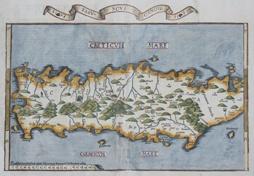
Tabu Nova Candie / Tabula Neoterica Cretae sive Candiae

| Article ID | EUK2760 |
Title | Tabu Nova Candie / Tabula Neoterica Cretae sive Candiae |
Description | Map shows the Greek island of Crete with mileage scale and title loop. |
| Year | ca. 1535 |
Artist | Ptolemy/ Fries (1490-1531) |
Lorenz (Laurent) Fries was born in Alsace in 1490 or thereabouts, describing himself on one occasion as from Colmar, one of the towns of the region. He studied medicine at university, or rather at universities, as he seems to have had a peripatetic education, apparently spending time at the universities of Pavia, Piacenza, Montpellier and Vienna. Having successfully completed his education, Fries established himself as a physician, at a succession of places in the Alsace region, with a short spell in Switzerland, before settling in Strasbourg, in about 1519. By this time, he had established a reputation as a writer on medical topics, with several publications already to his credit. Indeed, it was thus that Fries met the Strasbourg printer and publisher Johann Grüninger, an associate of the St. Die group of scholars formed by, among others, Walter Lud, Martin Ringmann and Martin Waldseemuller. Gruninger was responsible for printing several of the maps prepared by Waldseemuller, and for supervising the cutting of the maps for the 1513 edition of Ptolemy, edited by the group. This meeting was to introduce a important digression into Fries' life, and for the next five years, from about 1520 to about 1525, he worked in some capacity as a cartographic editor with Gruninger, exploiting the corpus of material that Waldseemuller had created. The first edition of Ptolemy's Geographia editet by Fries was published in Strasbourg in 1522, with maps that were copied and re-engraved from those of Martin Waldseemüller of the 1520 edition of Ptolemy and text edited by Pirckheimer. In 1525 a second edition was printed in Strasbourg. At the death of Fries and Gruninger, the plates were purchased by the brother Melchior and Gaspar Treschel, who printed a thord edition in Lyon in 1535. For the text, the two editors used the supervision of Michael Servetus, who editet Pirckheimer's text. Finally, in 1541, Gaspare Treechsel published in Vienne, in the Dauphine, this fourth edition, again with Servetus' text. in this edition, compared to the first edition of Strasbourg in 1522, the text underwent numerous changes, corrections and additions, but the wood-Blocks were not changed. Claudius Ptolemy ( arround 100- 160 a.C.) Geographia, gives a list of geographic coordinates of spherical longitude and latitude of almost ten thousand point locations on the earth surface, as they were known at his times. The list is organized in Tabulae which cor- respond to specific regions of the three known continents at that time, Africa, Asia and Europe. Research on Ptolemy’s Geographia has started at the University of Thessaloniki, Greece, in the eighties, focused mainly, but not exclusively, on data re- lated to territories which are now under the sovereignty of the modern Greek state. The World of Ptolemy is classified in Regions, since each Chapter is referred to one of them, giving by this way the concept of Atlas as it is understood today. | |
Historical Description | The island of Crete is first referred to as Kaptara in texts from the Syrian city of Mari from the 18th century BC, which are later repeated in Neo-Assyrian records and in the Bible (Caphtor). It was also known in ancient Egypt as Keftiu, strongly suggesting that a similar form to both was the Minoan name for the island. In classical times, Crete lay on the edge of the Greek cultural area, it was regarded as the "island of 100 poleis" and was therefore divided into numerous small city-states. The stone-carved legal text of the then powerful polis of Gortyn is the only completely preserved codex of this type from Greek antiquity. From 1645 to 1648, the Turks conquered almost the entire island and incorporated it into the Ottoman Empire as Girit, with only Candia withstanding a siege until 1669. Numerous uprisings by the population in the 19th century against Ottoman sovereignty were bloodily suppressed. From 1830 to 1840, Crete was formally under the administration of the Vali of Egypt, Muhammad Ali Pasha. In 1898, the intervention of France, Russia and the United Kingdom forced Crete into almost complete autonomy under the sovereignty of the High Porte. The Treaty of London in 1913 finally made Crete part of the Greek state, and a comprehensive population exchange was agreed in the Treaty of Lausanne in 1923. |
| Place of Publication | Lyon |
| Dimensions (cm) | 31 x 45,5 cm |
| Condition | Lower left corner replaced, tear in centerperfectly restored |
| Coloring | original colored |
| Technique | Copper print |