

Adina Sommer
Antique and Contemporary Art
Winzerer Str. 154
80797 München
telephone
+49 89 304714
business hours:
by appointment
Email
![]()


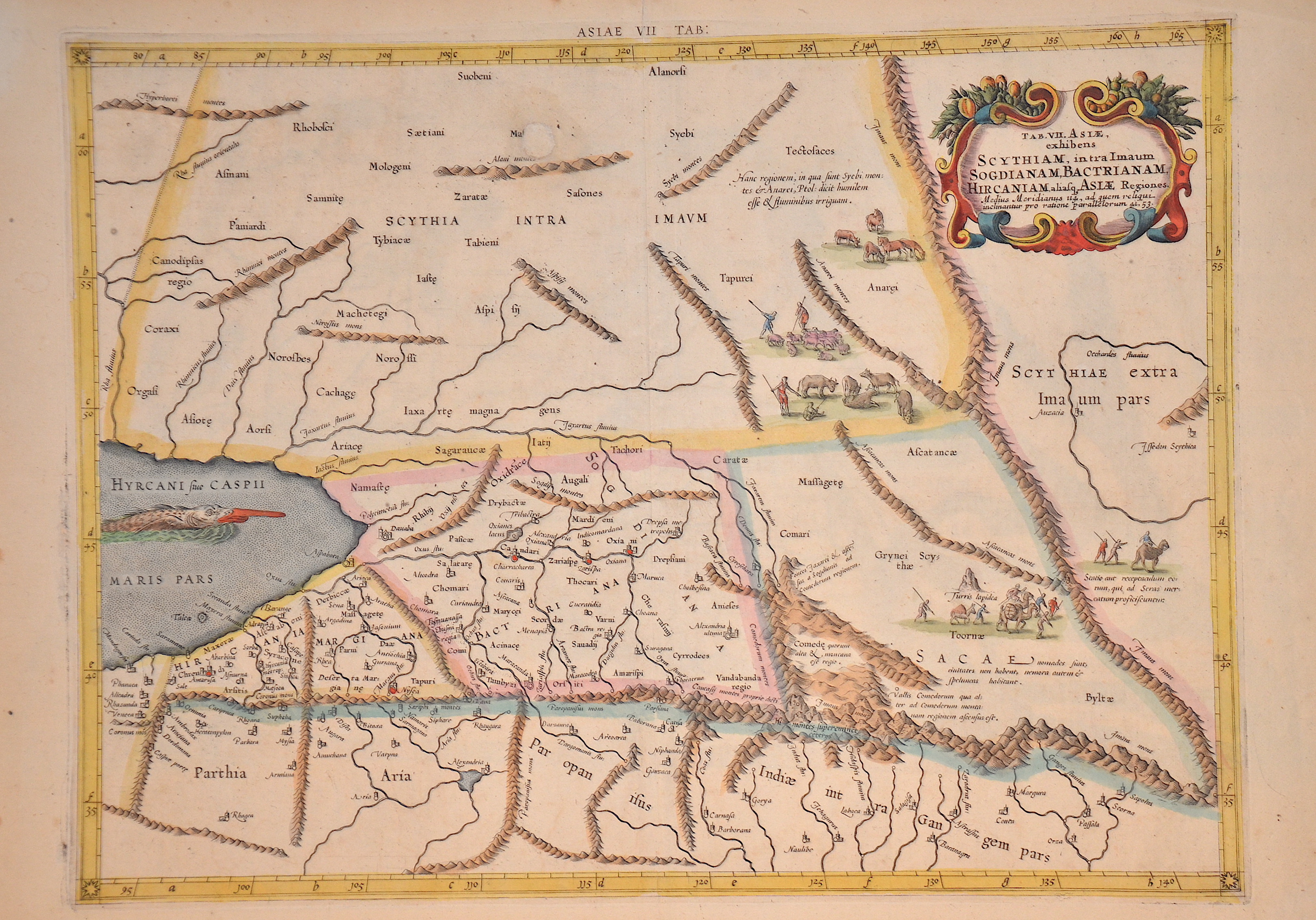
Tab. VII. Asiae exhibens Scythiam, intra Imaum Sogdianam, Bactrianam, Hircaniam……….

| Article ID | EUO2354 |
Title | Tab. VII. Asiae exhibens Scythiam, intra Imaum Sogdianam, Bactrianam, Hircaniam………. |
Description | Map shows the eastern part of the Caspian Sea with parts of Kazakhstan and Afghanistan. The Himalayas and northern India run across the bottom of the map. There are also figurative staffages, a sea monster and a title cartouche. Mercator originally published this map in his 1578 edition of Ptolemy's Great Geography. This map is from a 1698 edition and the ornamental border of the map first appeared in this edition. |
| Year | ca. 1698 |
Artist | Ptolemy/ Gerhard Mercator (1512-1594) |
Gerardus Mercator (1512 - 1594) He was a cartographer, philosopher and mathematician. He is best known for his work in cartography, in particular the world map of 1569 based on a new projection which represented sailing courses of constant bearing as straight lines. He is renowned to the present day as the cartographer who created a world map based on a new projection which represented sailing courses of constant bearing as straight lines. In his own day he was the world's most famous geographer but in addition he had interests in theology, philosophy, history, mathematics and magnetism as well as being an accomplished engraver, calligrapher and maker of globes and scientific instruments. He wrote few books but much of his knowledge is to be found in the copious legends on his wall maps and the prefaces that he composed for his atlas ,the first in which the term ""atlas"" appears and the sections within it." Claudius Ptolemy ( arround 100- 160 a.C.) Geographia, gives a list of geographic coordinates of spherical longitude and latitude of almost ten thousand point locations on the earth surface, as they were known at his times. The list is organized in Tabulae which cor- respond to specific regions of the three known continents at that time, Africa, Asia and Europe. Research on Ptolemy’s Geographia has started at the University of Thessaloniki, Greece, in the eighties, focused mainly, but not exclusively, on data re- lated to territories which are now under the sovereignty of the modern Greek state. The World of Ptolemy is classified in Regions, since each Chapter is referred to one of them, giving by this way the concept of Atlas as it is understood today. | |
Historical Description | Since the Caspian Sea is not a sea in the legal sense, it is not subject to the 1994 Convention on the Law of the Sea. The oldest cultural evidence can be found on inscriptions on Assyrian pottery and call it a "Southern Sea". the first popular name refers to the tribe of the Caspians who lived on the southwestern bank of the Caspian Caucasus, in today's Azerbaijan, the second refers to the bank near Hyrkania, a landscape on today's Iranian and southern Turkmen coast. The changing history of settlement led to numerous other names such as B. the Tatar name "Ag Deniz", White Sea. |
| Dimensions (cm) | 35 x 46 cm |
| Condition | Missing part at upper left margin replaced |
| Coloring | original colored |
| Technique | Copper print |