

Adina Sommer
Antique and Contemporary Art
Winzerer Str. 154
80797 München
telephone
+49 89 304714
business hours:
by appointment
Email
![]()


Suite du Golphe de Bothnie
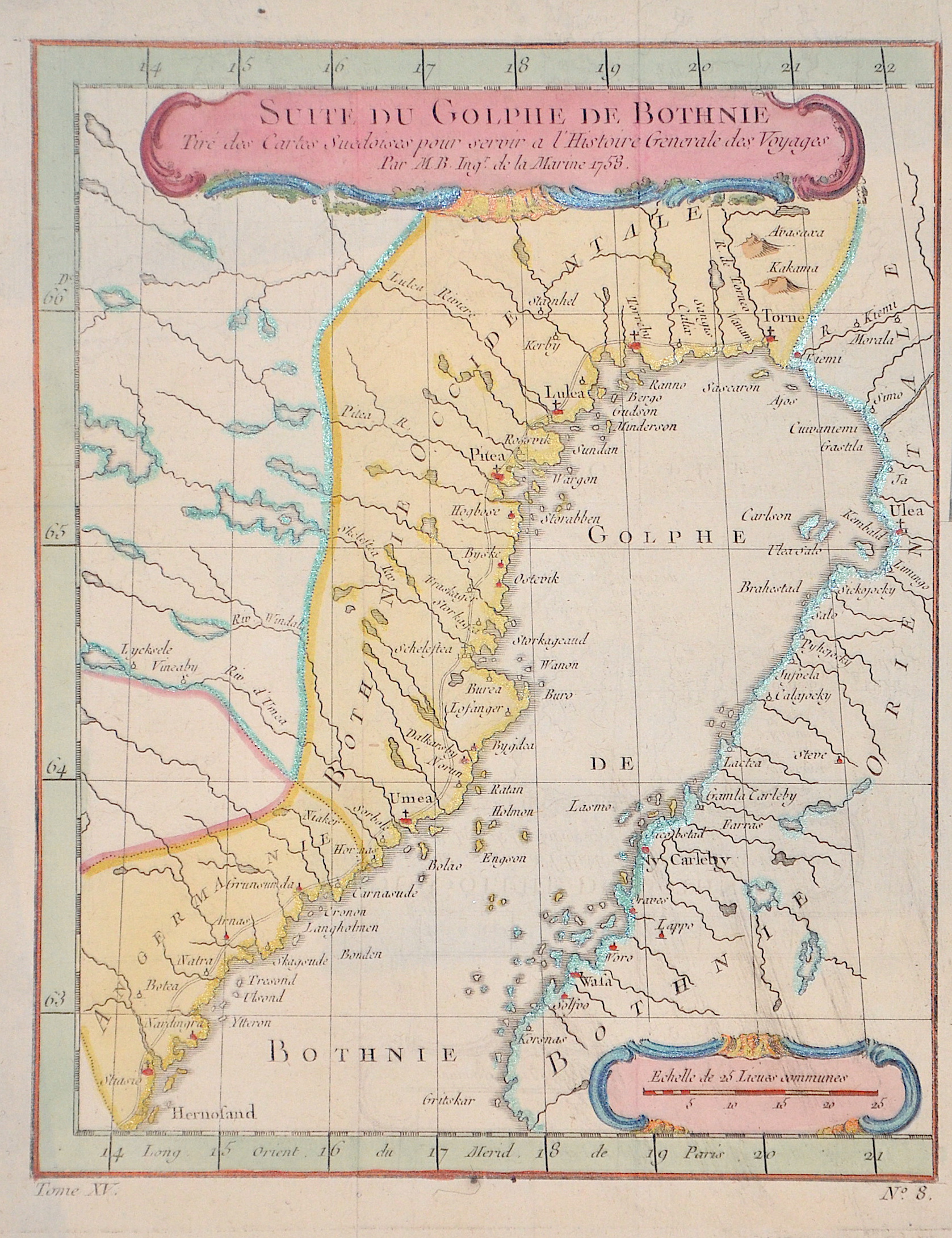

| Article ID | EUS1886 |
Title | Suite du Golphe de Bothnie |
Description | Map shows the bay of Bottnia between Finnland and Sweden with the cities of Härnösand,Umea, Pitea, lulea Torneo, Oulu and Vasa |
| Year | dated 1758 |
Artist | Bonne (1727-1795) |
Rigobert Bonne (1727–1795) was one of the most important cartographers of the late 18th century. In 1773 Bonne succeeded Jacques Nicolas Bellin as Royal Cartographer to France in the office of the Hydrographer at the Depôt de la Marine. Working in his official capacity, Bonne compiled some of the most detailed and accurate maps of the period. Bonne’s work represents an important step in the evolution of the cartographic ideology away from the decorative work of the 17th and early 18th century towards a more detail oriented and practical aesthetic. With regard to the rendering of terrain Bonne maps bear many stylistic similarities to those of his predecessor, Bellin. However, Bonne maps generally abandon such common 18th century decorative features such as hand coloring, elaborate decorative cartouches, and compass roses. While mostly focusing on coastal regions, the work of Bonne is highly regarded for its detail, historical importance, and overall aesthetic appeal. | |
Historical Description | Finland's Stone Age population consisted of hunters and gatherers. With the Bronze Age around 1700 BC Began, starting from the coastal regions, agriculture and animal husbandry. From 100 BC Trade with Central Europe increased. During the time of the Great Migration, the Finnish coastal regions became prosperous through trade in the Baltic Sea, which increased further in the time of the Vikings from the 8th century. Around the turn of the millennium, relations between eastern Finland and Novgorod intensified through trade with the east. With the trade connections the people of Finland came into contact with the Christian faith, in the west with the Roman Catholic, in the east with the Orthodox. The connection of western Finland to Sweden was a gradual process. The strengthened powers Sweden and Novgorod entered into competition for political, economic and religious reasons for the area inhabited by the Finns. Both states undertook several more or less military crusades into the region from the 12th century. The border between the two powers and thus the eastern border of Finland was first established in the Treaty of Nöteborg in 1323. During the Middle Ages, a European-style corporate society, urban system and Catholic church organization emerged in Finland. From the end of the 14th century until its disintegration at the beginning of the 16th century, Finland was part of Sweden as part of the Kalmar Union. During the reign of Gustav I. Wasa from 1523 to 1560, Sweden developed into a strong central state, which formed the basis for the empire's position as a great power in the 17th century. Also under Gustav Wasa, Catholicism was replaced by the Evangelical Lutheran creed in the course of the Reformation. During the great power period, Sweden managed to expand its territory in wars with Denmark, Poland and Russia around the Baltic Sea. Finland, which was spared acts of war during this time, was more closely integrated into the imperial administration. Under the leadership of Governor General Per Brahe the Younger, several new cities were founded, the academy and a court in Turku were established, and a postal system was set up. |
| Place of Publication | Paris |
| Dimensions (cm) | 21 x 17 |
| Condition | Very good |
| Coloring | original colored |
| Technique | Copper print |