

Adina Sommer
Antique and Contemporary Art
Winzerer Str. 154
80797 München
telephone
+49 89 304714
business hours:
by appointment
Email
![]()


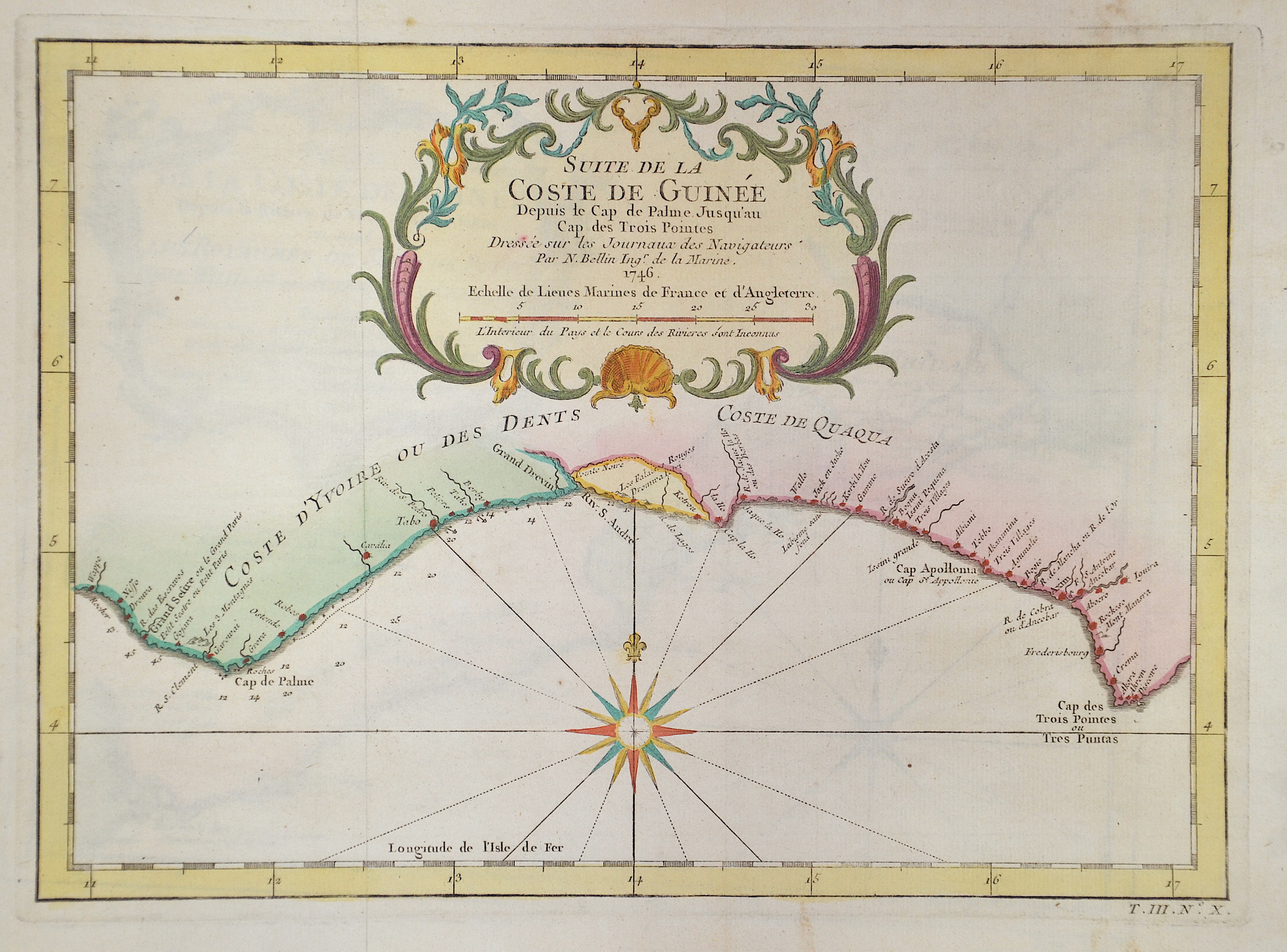
Suite de la Coste de Guinée

| Article ID | AF0528 |
Title | Suite de la Coste de Guinée |
Description | Map showing part of the coast of Ghana with the town of Axim and a title cartouche. |
| Year | c. 1746 |
Artist | Bellin (1703-1772) |
Jacques-Nicolas Bellin (1703 Paris -1772 Versailles) was a French cartographer, engineer-geographer, marine hydrographer. As a contributor to the Encyclopédie, he wrote more than a thousand articles on maritime topics. As a cartographer, Bellin distinguished himself primarily in the field of sea cartography. From 1721 he worked for the Dépot des Cartes et Plans de la Marine, from 1741 until his death as an engineer-hydrograph of the Navy. In 1753 his atlas Neptune français, which covered all the coasts of France, was published, and in 1756 the hydrography françoise covering all seas of the earth. In 1764 the five-volume Petit Atlas maritime was published, which Bellin prepared on the orders of the Minister of the Navy, Choiseul. In addition, he wrote a number of geographical works and with Nouvelle méthode pour apprendre la geographie (1769) a geographic textbook for teaching. His maps illustrated, among other things, Bougainville's work Voyage autour du monde, published in 1771. As a co-author of the Encyclopédie edited by Diderot and d'Alembert, Bellin wrote more than a thousand articles in the field of shipping and navy. | |
Historical Description | The first inhabitants of Ghana were members of the Sango or Sangoan culture - named after the first locations in Sango Bay on the Ugandan side of Lake Victoria. The population strata in Ghana and Togo, which are now considered to be autochthonous, are essentially groups who immigrated in large groups from the north or northeast to the areas south of the savannah belt of Togo and Ghana from the 9th and 10th centuries. This migratory movement was triggered by a change in the climate, which was associated with changes in the vegetation of the savannah areas. The modern state of Ghana takes its name from the ancient Kingdom of Ghana, which was geographically located a few thousand kilometers northwest and has no ethnic or historical connection to the current state of Ghana. In the pre-colonial period there were several large empires or federations on the territory of the present-day state. The first of these states, the empires of Dagomba, Mamprusi or Gonja, arose in the savannah region in northern Ghana and was culturally shaped by the empire of the Mossi further north and by Islam. Around 1600 the Ashanti Empire began to rise in central Ghana to become the dominant power in all of present-day Ghana. On the Gold Coast, the fortified settlements of European powers (Portuguese, English, Dutch, Brandenburgers, Swedes, Danes) have been lined up in a density like in no other area of Africa since the 17th century. Around 1820 the Colonial Office took over the British trading post on the Gold Coast. An agreement was reached between the British and the Fanti to defend themselves against the Ashanti from inland. In 1874 the British declared the coastal strip a crown colony. In 1957 the British crown colony Gold Coast and British Togoland became independent under the name Ghana. |
| Place of Publication | Paris |
| Dimensions (cm) | 21 x 29 cm |
| Condition | Perfect condition |
| Coloring | original colored |
| Technique | Copper print |