

Adina Sommer
Antique and Contemporary Art
Winzerer Str. 154
80797 München
telephone
+49 89 304714
business hours:
by appointment
Email
![]()


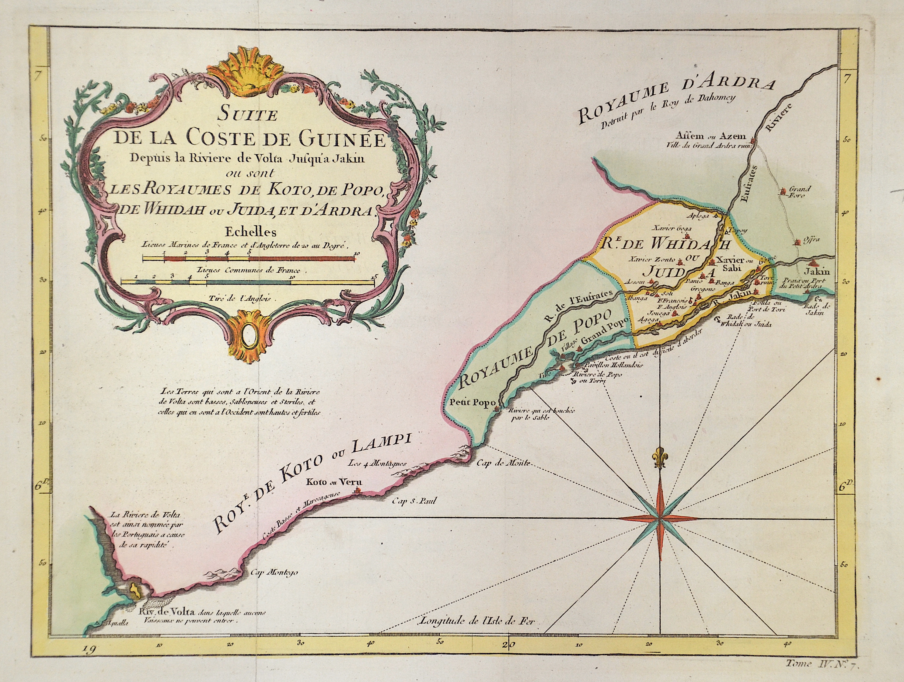
Suite de la Coste de Guinee. Depuis la Riviere de Volta Jusqu’a Jakin ou sont Les Royaumes de Koto, de Popo, de Whidah ou Juida, et d’Ardra.

| Article ID | AF0529 |
Title | Suite de la Coste de Guinee. Depuis la Riviere de Volta Jusqu’a Jakin ou sont Les Royaumes de Koto, de Popo, de Whidah ou Juida, et d’Ardra. |
Description | Map shows the coast of Benin with the cities, Grand-Popo, Ouidah, and many more. Top left a title cartouche and in the Bay of Benin a compass rose. |
| Year | ca. 1740 |
Artist | Bellin (1703-1772) |
Jacques-Nicolas Bellin (1703 Paris -1772 Versailles) was a French cartographer, engineer-geographer, marine hydrographer. As a contributor to the Encyclopédie, he wrote more than a thousand articles on maritime topics. As a cartographer, Bellin distinguished himself primarily in the field of sea cartography. From 1721 he worked for the Dépot des Cartes et Plans de la Marine, from 1741 until his death as an engineer-hydrograph of the Navy. In 1753 his atlas Neptune français, which covered all the coasts of France, was published, and in 1756 the hydrography françoise covering all seas of the earth. In 1764 the five-volume Petit Atlas maritime was published, which Bellin prepared on the orders of the Minister of the Navy, Choiseul. In addition, he wrote a number of geographical works and with Nouvelle méthode pour apprendre la geographie (1769) a geographic textbook for teaching. His maps illustrated, among other things, Bougainville's work Voyage autour du monde, published in 1771. As a co-author of the Encyclopédie edited by Diderot and d'Alembert, Bellin wrote more than a thousand articles in the field of shipping and navy. | |
Historical Description | The territory of the present-day state of Benin formed most of the Kingdom of Dahomey from the 17th century until 1805, when it was occupied by the French on behalf of Napoleon Bonaparte and incorporated into the French Empire as a colony. However, the colony was abandoned in 1814 with the defeat to Great Britain in the British-French Colonial Conflict. In 1863, the Second Empire assumed protectorate over the Kingdom of Porto-Novo in the south of the country, and in 1868 over Cotonou. In the years after 1879, the seizure of the northern territories began. After the conquest of the Kingdom of Dahomey in the 1890s, present-day Benin was part of French West Africa from 1899 to 1960, with Dakar as its capital. The last king, Béhanzin, was deported to the Caribbean island of Martinique. The conquest was largely carried out by troops from Senegal. The port of Cotonou was developed to open up the country. During World War II, the colony initially remained loyal to the Vichy government and fell to de Gaulle's Free France in November 1942. |
| Place of Publication | Paris |
| Dimensions (cm) | 20,5 x 27 cm |
| Condition | Perfect condition |
| Coloring | colored |
| Technique | Copper print |