

Adina Sommer
Antique and Contemporary Art
Winzerer Str. 154
80797 München
telephone
+49 89 304714
business hours:
by appointment
Email
![]()


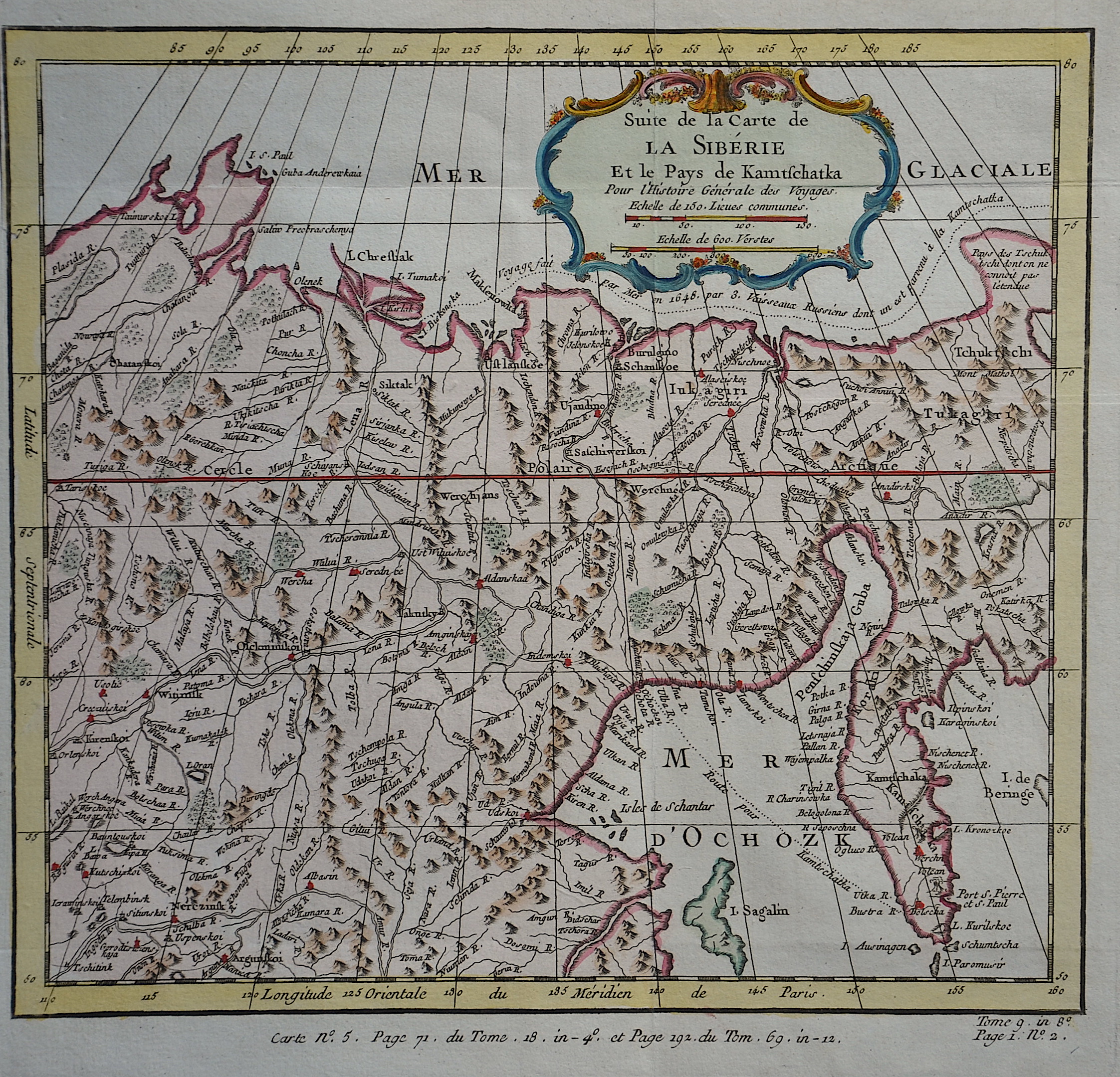
Suite de la Carte de la Siberie et le pays de Kamtschatka

| Article ID | EUO2255 |
Title | Suite de la Carte de la Siberie et le pays de Kamtschatka |
Description | Map shows Siberia with Kamtschatka. |
| Year | ca. 1760 |
Artist | Bonne (1727-1795) |
Rigobert Bonne (1727–1795) was one of the most important cartographers of the late 18th century. In 1773 Bonne succeeded Jacques Nicolas Bellin as Royal Cartographer to France in the office of the Hydrographer at the Depôt de la Marine. Working in his official capacity, Bonne compiled some of the most detailed and accurate maps of the period. Bonne’s work represents an important step in the evolution of the cartographic ideology away from the decorative work of the 17th and early 18th century towards a more detail oriented and practical aesthetic. With regard to the rendering of terrain Bonne maps bear many stylistic similarities to those of his predecessor, Bellin. However, Bonne maps generally abandon such common 18th century decorative features such as hand coloring, elaborate decorative cartouches, and compass roses. While mostly focusing on coastal regions, the work of Bonne is highly regarded for its detail, historical importance, and overall aesthetic appeal. | |
Historical Description | During the Russian Empire, Siberia was chiefly developed as an agricultural province. The government also used it as a place of exile, sending Avvakum, Dostoevsky, and the Decemberists, among others, to work camps in the region. During the 19th century, the Trans-Siberian Railway was constructed, supporting industrialization. This was also aided by the discovery and exploitation of vast reserves of Siberian mineral resources. The early history of Siberia was greatly influenced by the sophisticated nomadic civilizations of the Scythians (Pazyryk) on the west of the Ural Mountains and Xiongnu (Noin-Ula) on the east of the Urals, both flourishing before the Christian era. The steppes of Siberia were occupied by a succession of nomadic peoples, including the Khitan people, various Turkic peoples, and the Mongol Empire. In the late Middle Ages. They had long maintained relations with the people of the Siberian forest (taiga). Tibetan Buddhism spread into the areas south of Lake Baikal. As early as the 11th century the Novgorodians had occasionally penetrated into Siberia. After the fall of the Novgorod Republic its communications between Northern Russia and Siberia were inherited by the Grand Duchy of Moscow. With the breakup of the Golden Horde late in the 15th century, the Khanate of Sibir was founded with its center at Tyumen. The non-Borjigin Taybughid dynasty vied for rule with the descendants of Shiban. In the beginning of the 16th century Tatar fugitives from Turkestan subdued the loosely associated tribes inhabiting the lowlands to the east of the Ural Mountains. In the mid-16th century the Tsardom of Russia conquered the Tatar khanates of Kazan and Astrakhan, thus annexing the entire Volga Region and making the way to the Ural Mountains open. The main treasure to attract Cossacks to Siberia was the fur of sables, foxes, and ermines. Explorers brought back many furs from their expeditions. |
| Place of Publication | Paris |
| Dimensions (cm) | 24 x 26 |
| Condition | Very good |
| Coloring | original colored |
| Technique | Copper print |