

Adina Sommer
Antique and Contemporary Art
Winzerer Str. 154
80797 München
telephone
+49 89 304714
business hours:
by appointment
Email
![]()


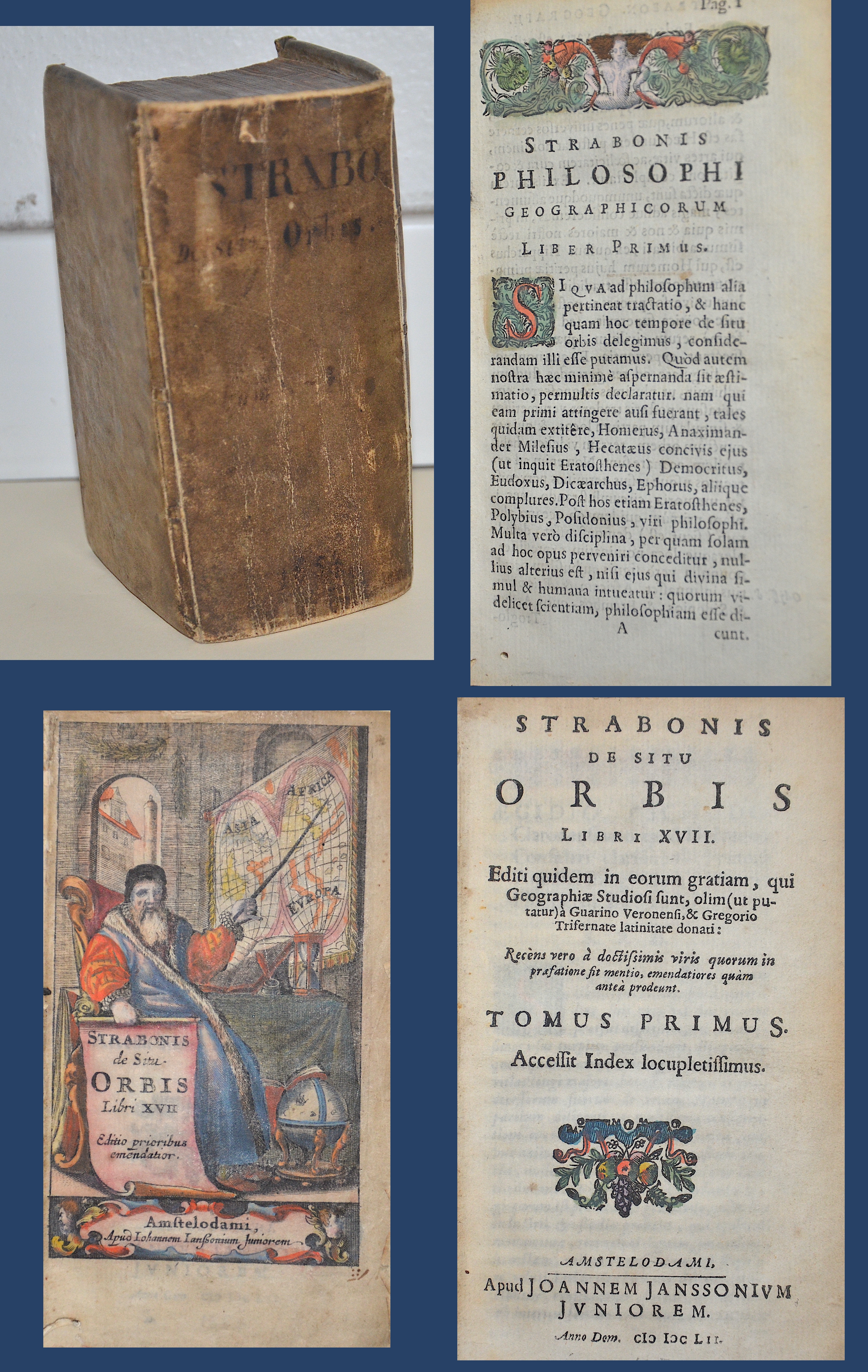
Strabonis de Situ Orbis Libri XVII Editio prioribus emendatior.

| Article ID | B0227 |
Title | Strabonis de Situ Orbis Libri XVII Editio prioribus emendatior. |
Description | Volume I translated into Latin from the original Greek by the Greek historian and geographer Strabo. A splendidly coloured title page, woodcut title vignette, initials, headpieces and endpieces. In 670 pages plus index and 12 page preface. The Greek historian and geographer Strabo (63 BC-23 AD) ca , who arrived in Rome around 45 BC, was a student of the Peripatetic philosopher Xenarchos and the grammarian Tyrannion. His extensive geographical treatise in 17 books is a fundamental text for understanding the territories, history and customs of the ancient world. Strabo described the earth and its peoples in Rome during the reign of Tiberius, covering recent events and conquests, but also providing some historical details. Strabo did not become known in Western Europe until the mid-fifteenth century, and his idea that India could be reached by travelling west around the world was put into practice by Christopher Columbus. |
| Year | c. 1652 |
Artist | Janssonius (1588-1664) |
Johannes Janssonius (Jansson)( 1588- 1664) Amsterdam, was born in Arnhem, the son of Jan Janszoon the Elder, a publisher and bookseller. In 1612 he married Elisabeth de Hondt, the daughter of Jodocus Hondius. He produced his first maps in 1616 of France and Italy. In 1623 Janssonius owned a bookstore in Frankfurt am Main, later also in Danzig, Stockholm, Copenhagen, Berlin, Königsberg, Geneva and Lyon. In the 1630s he formed a partnership with his brother in law Henricus Hondius, and together they published atlases as Mercator/Hondius/Janssonius. Under the leadership of Janssonius the Hondius Atlas was steadily enlarged. Renamed Atlas Novus, it had three volumes in 1638, one fully dedicated to Italy. 1646 a fourth volume came out with ""English County Maps"", a year after a similar issue by Willem Blaeu. Janssonius' maps are similar to those of Blaeu, and he is often accused of copying from his rival, but many of his maps predate those of Blaeu and/or covered different regions. By 1660, at which point the atlas bore the appropriate name ""Atlas Major"", there were 11 volumes, containing the work of about a hundred credited authors and engravers. It included a description of ""most of the cities of the world"" (Townatlas), of the waterworld (Atlas Maritimus in 33 maps), and of the Ancient World (60 maps). The eleventh volume was the Atlas of the Heavens by Andreas Cellarius. Editions were printed in Dutch, Latin, French, and a few times in German. | |
| Place of Publication | Amsterdam |
| Dimensions (cm) | 14 x 8 cm |
| Condition | Binding in leather |
| Coloring | original colored |
| Technique | Copper print |