

Adina Sommer
Antique and Contemporary Art
Winzerer Str. 154
80797 München
telephone
+49 89 304714
business hours:
by appointment
Email
![]()


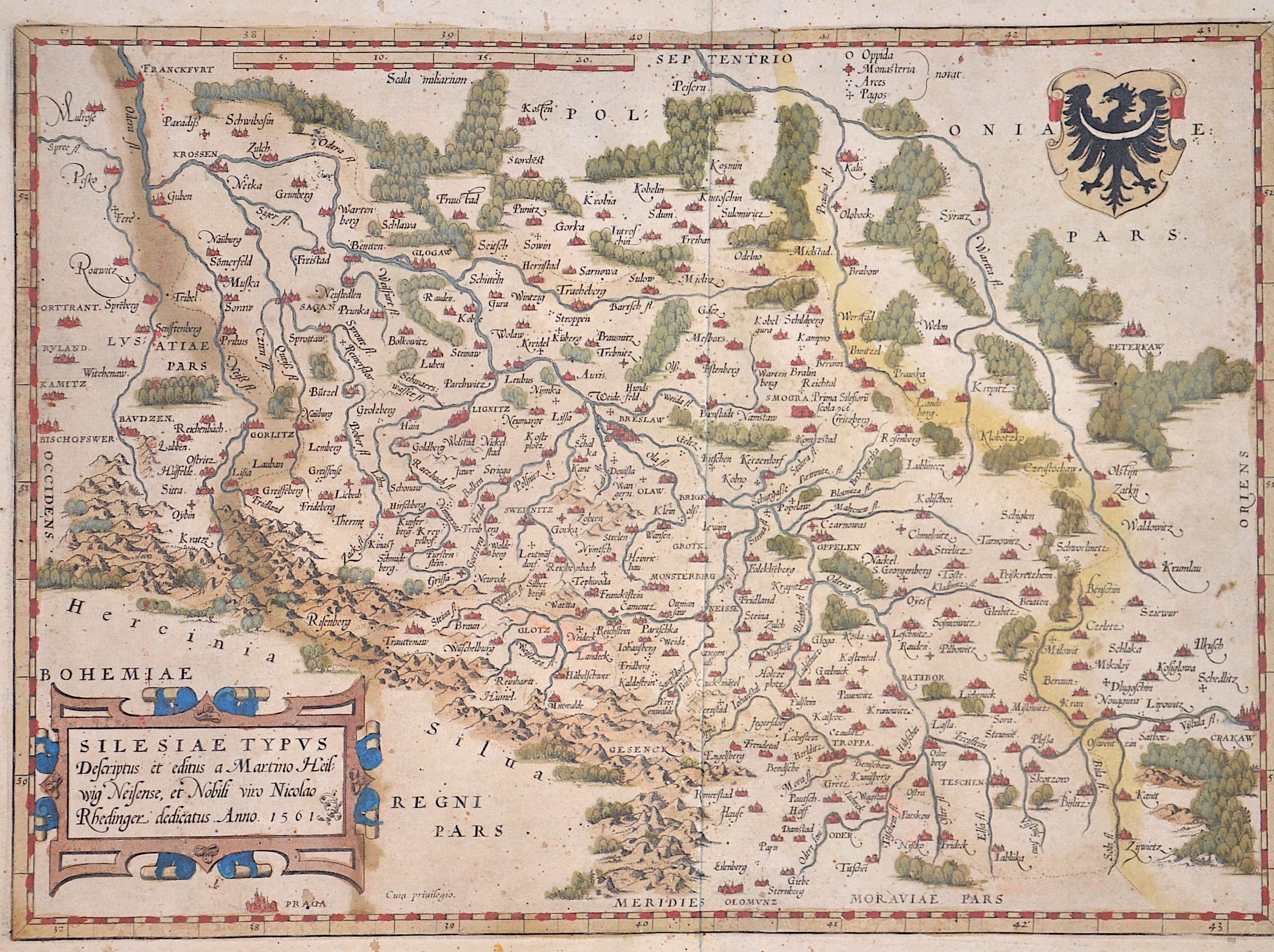
Silesiae Typus descriptus et editus a Martino Heilwig Neissnese, et Nobili viro Nocolao Rhedinger dedicatus Anno 1561

| Article ID | EUP2900 |
Title | Silesiae Typus descriptus et editus a Martino Heilwig Neissnese, et Nobili viro Nocolao Rhedinger dedicatus Anno 1561 |
Description | Map shows total Silesia with scrollwork cartouche and coat of arm. |
| Year | ca. 1579 |
Artist | Ortelius (1527-1598) |
Abraham Ortelius (1527–1598) was a Flemish cartographer and publisher from Antwerp. Originally a map colorist, he became a major figure in cartography through his Theatrum Orbis Terrarum (1570), considered the first modern atlas—a uniform collection of reliable maps in book form. Influenced by Gerardus Mercator, Ortelius published several maps before compiling the Theatrum, which clearly showed America as a separate continent. The work was published in 42 editions and 7 languages by 1612. Unlike many of his peers, Ortelius cited his sources, and his atlas became a milestone in mapmaking and geographic knowledge. | |
Historical Description | Silesia is a region in Central Europe on both sides of the upper and middle reaches of the Oder and extends in the south along the Sudetes and Beskids. Most of Silesia lies in what is now Poland. A small part in the west of Lower Silesia belongs to East Germany, a southern part of Upper Silesia to the Czech Republic. Between 1289 and 1292, Bohemian king Wenceslaus II became suzerain of some of the Upper Silesian duchies. Polish kings had not renounced their hereditary rights to Silesia until 1335. The province became part of the Bohemian Crown under the Holy Roman Empire, and passed with that crown to the Habsburg Monarchy of Austria in 1526. In the 15th century, several changes were made to Silesia's borders. Parts of the territories which had been transferred to the Silesian Piasts in 1178 were bought by the Polish kings in the second half of the 15th century. From 1526 to 1742 the Habsburgs, as kings of Bohemia, were also dukes of Silesia. Almost all of Silesia became Protestant in the 16th century. Well-known Silesian reformers were among others Johann Heß and Caspar von Schwenckfeld, whose theology was invoked by the Schwenkfeldians, who were represented in Silesia until the 17th century. After the First Silesian War it was agreed in the preliminary peace of Breslau (1742) that Austria had to cede Lower and Upper Silesia to the Oppa as well as the Bohemian County of Glatz to Prussia. Frederick the Great was able to defend this acquisition in the Second Silesian War and also in the Third Silesian War (1756 to 1763). A smaller part of Upper Silesia around Troppau, Jägerndorf, Teschen and Bielitz as well as the southern part of the Principality of Neisse, which belongs to Lower Silesia (= the political district of Freiwaldau until 1938) remained as Austrian Silesia (officially: "Duchy of Upper and Lower Silesia") until 1918 of the Austro-Hungarian monarchy. First (until 1782) as part of the Kingdom of Bohemia, then (until 1849 and 1860–1861) Moravia. According to a decree of March 4, 1849, all peoples of the Austrian Empire, including Silesians, were given equal rights. |
| Place of Publication | Antwerp |
| Dimensions (cm) | 28 x 38,5 cm |
| Condition | Some stains |
| Coloring | original colored |
| Technique | Copper print |