

Adina Sommer
Antique and Contemporary Art
Winzerer Str. 154
80797 München
telephone
+49 89 304714
business hours:
by appointment
Email
![]()


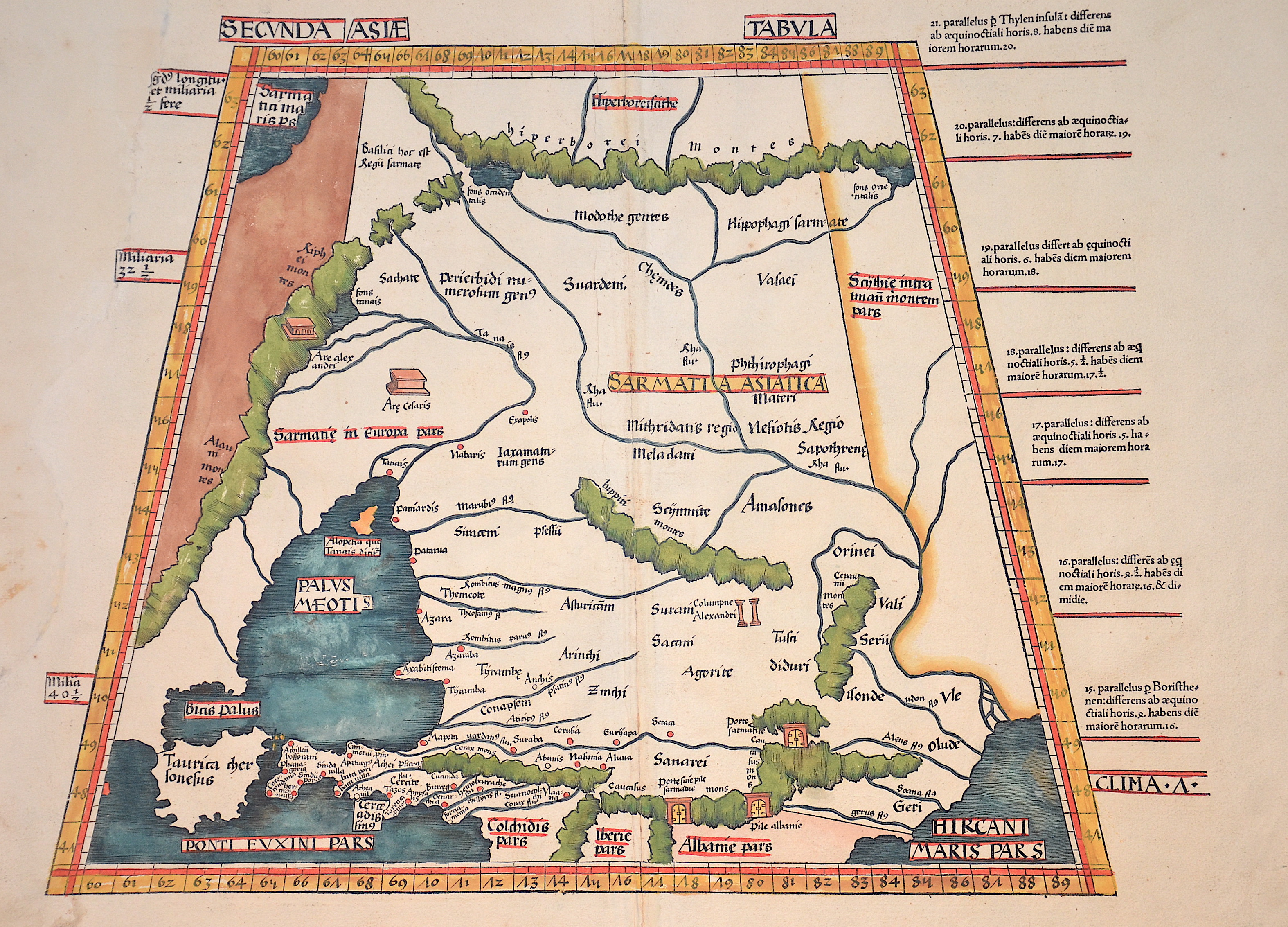
Secunda Asiae Tabula

| Article ID | EUO2608 |
Title | Secunda Asiae Tabula |
Description | Interesting map shows in Trapeziod shape former Sarmatia, now partly Russia with the Black Sea, the Ukraine and the peninsula Krim with the Asow sea. On reverse a dexcription with ornamental decoration. |
| Year | ca. 1513 |
Artist | Ptolemy/Waldseemüller- Johann Schott (1477-1550) |
Johann Schott (1477–1550) reissued Martin Waldseemüller’s maps, including 20 detailed regional maps in his atlas Tabula Moderna Germanie, making it one of the most important works of its time. Schott is also known for the atlases Alexandri Magni and Margarita philosophica. Martin Waldseemüller (born c. 1470s, Radolfzell, Germany) studied at Freiburg University and later moved to Lorraine, France, where he joined the intellectual circle Gymnasium Vosagense. He died in 1522. Waldseemüller created the 1507 wall map that first named America and completed maps for a 1513 edition of Ptolemy’s Geography. His atlas merged cartographic science with printing art and included 20 modern maps alongside Ptolemaic ones, using a new quadratic projection. Johannes Schott printed the atlas, with Waldseemüller providing the drawings. Editors Jacobus Äschler and George Uebel worked on the text. Supported by René, Duke of Lorraine, Waldseemüller developed new maps abandoning Ptolemy’s projection for rectilinear meridians and parallels. Due to the Duke’s death, printing was delayed until 1512. The atlas included 26 classical Ptolemaic maps plus 20 new ones published separately. The New World map was based on recent, reliable information attributed to “The Admiral,” believed to be Columbus, leading to the atlas being called the Admiral Atlas. Schott printed a version with minor corrections in Augsburg. Ptolemy’s Geographia (c. 100–160 AD) listed geographic coordinates for nearly 10,000 locations across Africa, Asia, and Europe, organized into regions—an early concept of an atlas. Research on this work, notably at the University of Thessaloniki, continues today. Most maps bear a watermark of a triple-pointed crown. | |
Historical Description | Neanderthal settlement in Ukraine is seen in the Molodova archaeological sites, which include a mammoth bone dwelling. The territory is also considered to be the likely location for the human domestication of the horse. In the mid-14th century, upon the death of Bolesław Jerzy II of Mazovia, king Casimir III of Poland initiated campaigns (1340–1366) to take Galicia-Volhynia. Meanwhile, the heartland of Rus', including Kiev, became the territory of the Grand Duchy of Lithuania, ruled by Gediminas and his successors, after the Battle on the Irpen' River. In 1648, Bohdan Khmelnytsky and Petro Doroshenko led the largest of the Cossack uprisings against the Commonwealth and the Polish king John II Casimir. After Khmelnytsky made an entry into Kiev in 1648, where he was hailed liberator of the people from Polish captivity, he founded the Cossack Hetmanate which existed until 1764. In 1657–1686 came "The Ruin", a devastating 30-year war amongst Russia, Poland, Turks and Cossacks for control of Ukraine. In 1709, Cossack Hetman Ivan Mazepa (1639–1709) defected to Sweden against Russia in the Great Northern War (1700–1721). Lithuanians and Poles controlled vast estates in Ukraine, and were a law unto themselves. After the Annexation of Crimea by the Russian Empire in 1783, New Russia was settled by Ukrainians and Russians. |
| Place of Publication | Strassburg |
| Dimensions (cm) | 38 x 51 cm |
| Condition | Left margin replaced |
| Coloring | original colored |
| Technique | Woodcut |