

Adina Sommer
Antique and Contemporary Art
Winzerer Str. 154
80797 München
telephone
+49 89 304714
business hours:
by appointment
Email
![]()


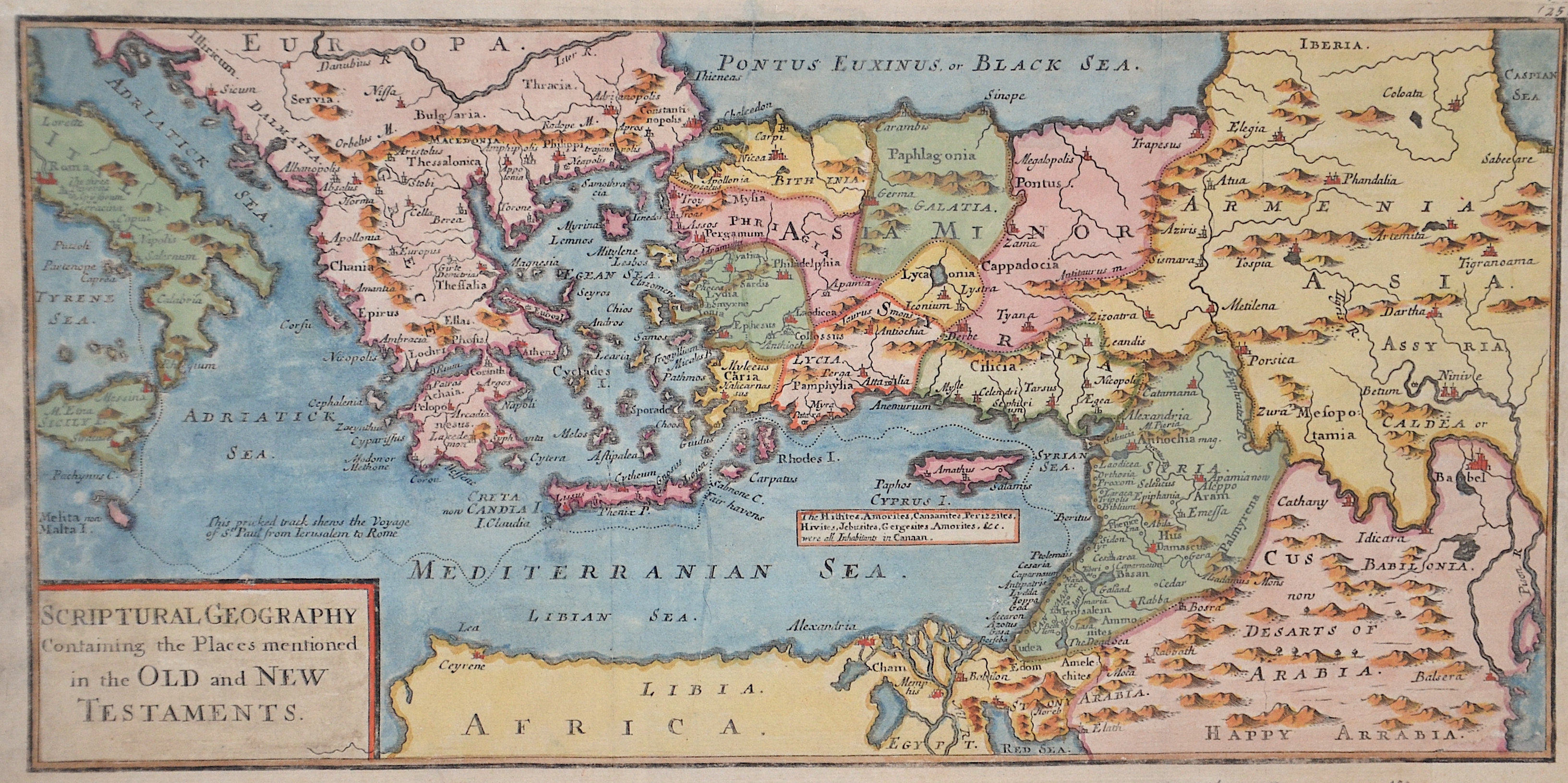
Scriptural Geography Containing the Places mentionednin the Old and New Testaments

| Article ID | EUX3054 |
Title | Scriptural Geography Containing the Places mentionednin the Old and New Testaments |
Description | Map shows the south eastern part of Europe and the Mediterranean sea with Italy, Greece, Turkey with Cyprus and north Africa, Egypt and Israel. |
| Year | ca. 1712 |
Artist | Moll (1654-1732) |
Hermann Moll (1654–1732) was a London-based engraver, cartographer, and publisher known for his detailed maps of Europe and the Americas. He also created maps for Defoe’s Robinson Crusoe and Swift’s Gulliver’s Travels. His major works include the Atlas Geographus (1711–1717) and Atlas Minor (1719), both published in multiple editions. Moll collaborated with explorer William Dampier, whose travel reports provided valuable geographic data for Moll’s maps. Dampier’s popularity and the public’s growing interest in travel literature helped boost Moll’s success, leading other authors like Defoe and Swift to use his illustrations. | |
Historical Description | Numerous paleoanthropological finds, for example from the Arago cave near Perpignan, prove that Homo erectus already lived in the Mediterranean. In the period of several hundred thousand years, the polar ice caps repeatedly expanded, glaciers covered the high mountains during the ice ages. The sea level was therefore temporarily up to 150 meters below today's level. The Strait of Gibraltar temporarily closed. The Stone Age replaced the Stone Age in different regions. Copper spreads first, then bronze. Spain, rich in metals, began around 2300 BC. The Bronze Age (El Argar culture). Numerous fortified settlements were created. The first states emerged with the Pharaoh dynasties around 3000 BC. BC in Egypt. Almost simultaneously, the first city-states were formed on the Levant and Aegean coasts. The great empires of the early days of Assyria, Babylonia and the Hittites - temporarily expanded into the Mediterranean area. Since the archaic period, i.e. from 800 BC BC, ancient Greece also emerged as a trading power and increasingly created competition for the Phoenicians. The Greeks settled as far as the Rhône (Massilia) and the Crimea and set up offices and factories as far as Egypt. Tuscany was the settlement area of the Etruscans, who also controlled the rich iron deposits of Elba. This culture developed from the local Villanova culture, later under strong Greek and Syrian ("oriental") influence. In Rome, the founding of Rome began with the slow but steady rise of the Romans, which began around 500 BC. BC finally emancipated from the Etruscans and founded the republic. The south of the Apennine Peninsula was characterized by the Greek colonies ("Magna Graecia"). At the same time, the Persian empire extended to Egypt and the Bosphorus, subjugating the Phoenicians and the Egyptians. The period of great Persian expansion coincided with the blossoming of Greece, which was able to ward off the Persian invasions in several battles. While the Greeks colonized large parts of the northern Mediterranean coast, the Phoenicians - after (Tire) had lost their independence - built Carthage in North Africa as a new power base and also established commercial branches in Spain (Cadiz), Morocco, Corsica and Sardinia. Sicily was contested between the great powers at that time because of its rich resources and location. In late antiquity, the slow Christianization of the Roman state began, which should have far-reaching consequences, such as the rejection of paganism. The late Middle Ages were characterized by a sustained upswing in the Italian area. Especially the Republic of Venice. The most important naval powers of the early modern period continued to be Venice and Genoa, which dominated trade with the Arab world and thus to Southeast Asia. They also had numerous colonies in the eastern Mediterranean. The War of the Spanish Succession brought about a reorganization of the western and central Mediterranean region in 1713. The French expansion was initially stopped, Spain was reduced to the mainland and the Balearic Islands and the Italian area was redistributed among the rulers. The winner was above all the Habsburg-Austrian line, which also won southern Italy, Sicily, Sardinia and Milan. However, this situation did not last long: the Spanish-Bourbon royal family soon regained control of the Italian territory. Most of the Maghreb were now ruled by Berber tribes, which were beyond the control of the Ottoman Empire but neglected the economy. Morocco and Algeria were marginalized economically, which invited the Spaniards to invasions. The Ceuta and Melilla bases are still under Spanish control. |
| Place of Publication | London |
| Dimensions (cm) | 16 x 32,5 |
| Condition | Lower right and upper left corner perfectly restored |
| Coloring | original colored |
| Technique | Copper print |