

Adina Sommer
Antique and Contemporary Art
Winzerer Str. 154
80797 München
telephone
+49 89 304714
business hours:
by appointment
Email
![]()


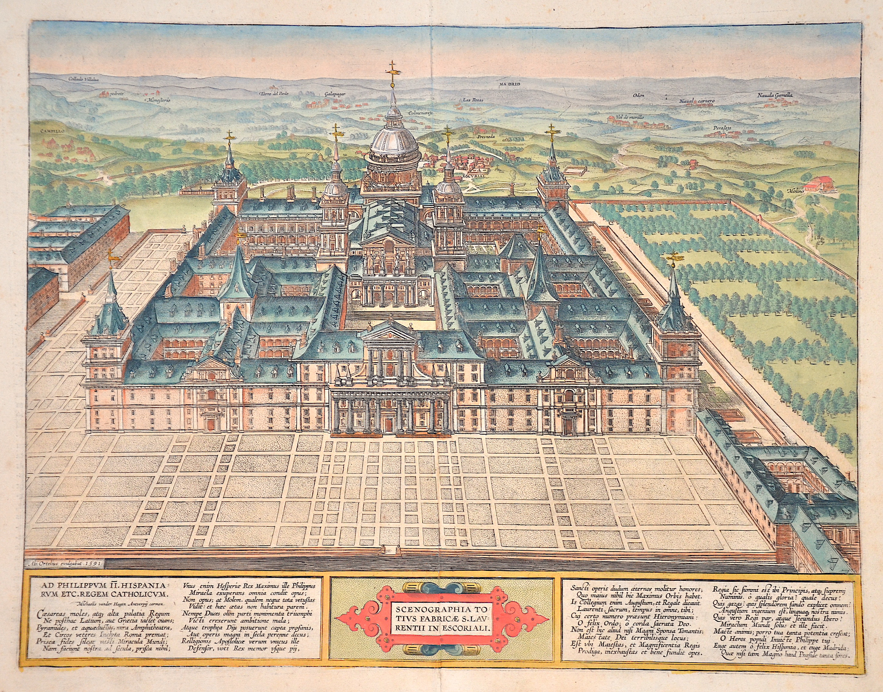
Scenographia totius fabricae S. Laurentii in Escoriali.

| Article ID | EUE5193 |
Title | Scenographia totius fabricae S. Laurentii in Escoriali. |
Description | Bird's-eye view of the Real Sitio de San Lorenzo de El Escorial (monastery residence El Escorial), the seat of the Spanish monarch Philip II near Madrid. From the atlas "Parergon" from 1595, with poems in praise of the Spanish king and a title cartouche below. Translation of the reverse: This building, almost unique in the world, is a monastery inhabited by Hieronymite monks, but also a royal palace and a hunting lodge, so charming and beautiful that it is in no way inferior to the seven wonders of the ancient world. The most beautiful gable of the monastery is on the west side, where it has three gates or doors, the centre one being the most beautiful and giving access to the church, the monastery and the chapter. |
| Year | ca. 1591 |
Artist | Ortelius (1527-1598) |
Abraham Ortelius (1527–1598) was a Flemish cartographer and publisher from Antwerp. Originally a map colorist, he became a major figure in cartography through his Theatrum Orbis Terrarum (1570), considered the first modern atlas—a uniform collection of reliable maps in book form. Influenced by Gerardus Mercator, Ortelius published several maps before compiling the Theatrum, which clearly showed America as a separate continent. The work was published in 42 editions and 7 languages by 1612. Unlike many of his peers, Ortelius cited his sources, and his atlas became a milestone in mapmaking and geographic knowledge. | |
Historical Description | The Real Sitio de San Lorenzo de El Escorial - "Royal Seat of St. Lawrence of El Escorial" - is a palace and monastery complex that was built between 1563 and 1584 on the initiative of King Philip II of Spain according to plans by Juan Bautista de Toledo and under the long-term supervision of Juan de Herrera in the central Spanish town of San Lorenzo de El Escorial in the northwest of the Madrid region. After Philip II of Spain defeated the French King Henry II at the Battle of Saint-Quentin in August 1557, the feast of Saint Lawrence, he vowed to build a monastery in honor of the saint. His astrologers chose the small Castilian town of El Escorial. Construction work began in 1563 and lasted until September 1584. Granite blocks from the Sierra de Guadarrama were used for the construction. El Escorial was designed by Juan Bautista de Toledo, a pupil of Michelangelo. After his death in 1567, Juan de Herrera succeeded him and became the actual builder of the Escorial. Almost all Spanish kings from Charles I to Alfonso XIII are buried in the Baroque crypt, which was extended by Juan Gómez de Mora in 1654. Charles IV, who did not like the austerity of the palace, built a Moorish-style pleasure palace, the Casita del Príncipe, nearby at the end of the 18th century. Since 1861, the Escorial has no longer been a royal residence. |
| Place of Publication | Antwerp |
| Dimensions (cm) | 50 x.40 cm |
| Condition | Lower centerfold somewhat restored |
| Coloring | original colored |
| Technique | Copper print |