

Adina Sommer
Antique and Contemporary Art
Winzerer Str. 154
80797 München
telephone
+49 89 304714
business hours:
by appointment
Email
![]()


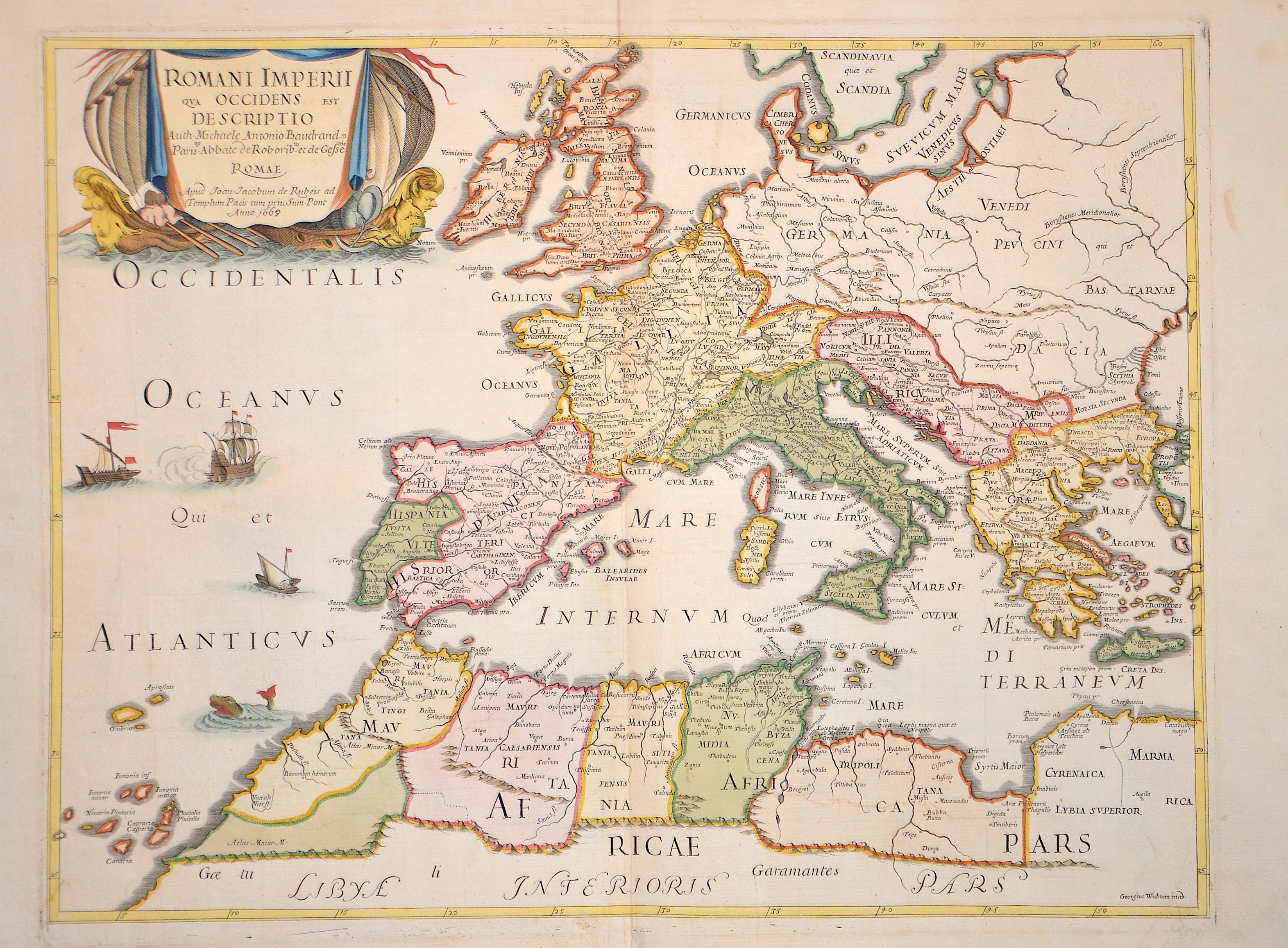
Romani Imperii qua occidens est descriptio Auth. Michaele Antonio Baudrand..

| Article ID | EUX5302 |
Title | Romani Imperii qua occidens est descriptio Auth. Michaele Antonio Baudrand.. |
Description | ap shows the western Roman Empire with Spain, France, England, Italy, Swizzerland, Austria, Croatia, Slovenia, Marocco, Algeria and Tunesia. De Rubeis was Giacomo Rossi's Latinized name, under which some of his maps appear in the early part of his career. This map was originally designed by Michel Antoine Baudrand (1633-1700), a French Historian and Geographer, who served as secretary to Cardinal Francesco Barberini (then Dean of the College of Cardinals) in Rome, during which time this map was originally conceived by Baudrand. |
| Year | c. 1669 |
Artist | Rossi (1627-1691) |
Giovanni Giacomo De' Rossi was the son of the founder of the most important and active printing press of the 17th century in Rome. Begun in 1633 by his father Giuseppe (1570-1639), the press passed firstly to Giacomo and to his brother Giandomenico (1619-1653), and then later to Lorenzo Filippo (1682-?); in 1738 it became the Calcografia Camerale, from 1870 until 1945 the Regia Calcografica, and today it is known as the Calcografia Nazionale. Here are conserved, amongst many others, the plates of Giambattista Piranesi (1720-1778). Giacomo De' Rossi was the most involved of all the various family members who ran the press, and he worked between 1638 and 1691, and was to take the company to the height of its success. De Rubeis was Giacomo Rossi's Latinized name, under which some of his maps appear in the early part of his career. | |
Historical Description | The history of Europe from the 15th to the 19th century was shaped by profound political, social, and cultural changes that formed modern Europe. At the beginning of the 15th century, Europe was marked by the effects of the Middle Ages and the feudal structure. A significant event was the Renaissance, which began around 1400 in Italy and marked a revival of classical ancient culture, art, and sciences. The invention of the printing press by Johannes Gutenberg around 1440 was also revolutionary and promoted the spread of knowledge. By the end of the century, European explorers, such as Christopher Columbus, began finding new trade routes, which led to the discovery of the New World. The 16th century was defined by the Reformation, when Martin Luther published his 95 Theses in 1517, challenging the Catholic Church. This led to religious conflicts and the division of Western Christianity into Catholics and Protestants. Politically, Europe saw the rise of the Habsburg Empire and the development of nation-states such as France and England. The age of exploration continued, leading to a new wave of colonization. The 17th century was a time of wars and political instability, including the Thirty Years' War (1618–1648), which devastated much of Europe. These conflicts resulted in significant territorial changes and the establishment of the modern Treaty of Westphalia in 1648. During this time, Absolutism took root, with monarchs like Louis XIV of France exercising absolute power. The 18th century was marked by the ideas of the Enlightenment, which emphasized reason, science, and individual freedom. This led to profound political and social reforms. At the same time, major wars such as the War of Spanish Succession (1701–1714) and the Seven Years' War (1756–1763) took place. The century ended with the events of the French Revolution (1789), which overthrew the monarchy and established the Republic. This paved the way for the Napoleonic Wars and the Napoleonic Era, which triggered political and social upheavals throughout Europe. The 19th century was shaped by the aftermath of the French Revolution and the Napoleonic Wars, which reshaped Europe's political system. After Napoleon's defeat in 1815, Europe was reorganized at the Congress of Vienna. Nationalism and Liberalism grew, leading to significant political upheavals, including the German Confederation, the unification of Italy, and the formation of the German Empire in 1871. At the same time, industrialization and urbanization began, significantly altering Europe's economic and social structure. The 19th century ended with the outbreak of World War I in 1914, which shattered the entire European power structure and many social systems. |
| Place of Publication | Rome |
| Dimensions (cm) | 38,5 x 50 cm |
| Condition | Some restoration at lower centerfold |
| Coloring | original colored |
| Technique | Copper print |