

Adina Sommer
Antique and Contemporary Art
Winzerer Str. 154
80797 München
telephone
+49 89 304714
business hours:
by appointment
Email
![]()


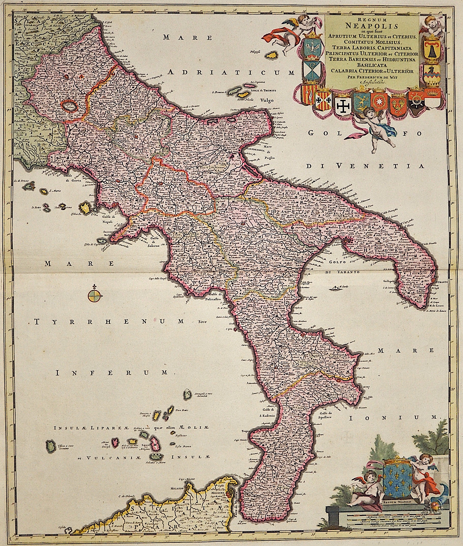
Regnum Neapolis in quo sunt Aprutium Ulterius et Citerius, comitatus Molisius, Terra la Boris, Capitaniata Principatus ulterior….

| Article ID | EUI1488 |
Title | Regnum Neapolis in quo sunt Aprutium Ulterius et Citerius, comitatus Molisius, Terra la Boris, Capitaniata Principatus ulterior…. |
Description | Map shows the whole of southern Italy with part of Sicily and the Lipari Islands. Furthermore, a title cartouche with 12 coats of arms from the region. Below a cartouche with mileage indicator and the coat of arms of the Kingdom of Naples with two putti depictions. |
| Year | ca. 1670 |
Artist | Wit, de (1610-1698) |
Frederik de Wit (1610 – 1698). His Atlas began to appear around 1662 and by 1671 included anywhere from 17 to 151 maps each. In the 1690s he began to use a new title page "Atlas Maior" but continued to use his old title page. His atlas of the Low Countries first published in 1667,was named Nieuw Kaertboeck van de XVII Nederlandse Provinciën and contained 14 to 25 maps. Frederik de Wit quickly expanded upon his first small folio atlas which contained mostly maps printed from plates that he had acquired, to an atlas with 27 maps engraved by or for him. By 1671 he was publishing a large folio atlas with as many as 100 maps. Smaller atlases of 17 or 27 or 51 maps could still be purchased and by the mid-1670s an atlas of as many as 151 maps and charts could be purchased from his shop. In ca.1675 Frederik de Wit released a new nautical atlas. The charts in this atlas replaced the earlier charts from 1664 that are known today in only four bound examples and a few loose copies. Frederik de Wit new charts were sold in a chart book and as part of his atlases. Frederik de Wit published no fewer than 158 land maps and 43 charts on separate folio sheets. In 1695 Frederik de Wit began to publish a town atlas of the Netherlands after he acquired a large number of city plans at the auction of the famous Blaeu publishing firm’s printing plates. Dating Frederik de Wit atlases is considered difficult because usually no dates were recorded on the maps and their dates of publication extended over many years. | |
Historical Description | Southern Italy consists of today's Italian regions that belonged to the Kingdom of Sicily before the unification of Italy in 1861. These are the regions of Abruzzo, Molise, Campania, Basilicata, Apulia, Calabria and Sicily. The Romans used to call the area of Sicily and coastal Southern Italy Magna Graecia ("Great Greece"), since it was so densely inhabited by the Greeks; the ancient geographers differed on whether the term included Sicily or merely Apulia and Calabria—Strabo being the most prominent advocate of the wider definitions. With this colonisation, Greek culture was exported to Italy, in its dialects of the Ancient Greek language, its religious rites and its traditions of the independent polis. An original Hellenic civilization soon developed, later interacting with the native Italic and Latin civilisations. The most important cultural transplant was the Chalcidean/Cumaean variety of the Greek alphabet, which was adopted by the Etruscans; the Old Italic alphabet subsequently evolved into the Latin alphabet, which became the most widely used alphabet in the world. In 1442 Alfonso V conquered the Kingdom of Naples and united Sicily and Naples as dependencies of the Crown of Aragon. When he died in 1458, the kingdom was again separated and Naples was inherited by Ferrante, Alfonso's illegitimate son. When Ferrante died in 1494, Charles VIII invaded Italy from France and used Angevin's claim to the throne of Naples, inherited by his father in 1481 after the death of King René's nephew, as an excuse to start the Italian wars. A point of contention between France and Spain for the next several decades, but French efforts to gain control of it weakened over the decades and Spanish control was never really compromised. The French finally gave up their claims to the kingdom through the Treaty of Cateau-Cambrésis in 1559. With the Treaty of London (1557) the new client state of the so-called Presidi ("State of Garrisons") was founded and directly ruled by Spain as part of the Kingdom of Naples. After the War of the Spanish Succession in the early 18th century, possession of the kingdom again changed hands. Under the terms of the Treaty of Utrecht in 1713, Naples was given to Charles VI, the Holy Roman Emperor. |
| Place of Publication | Amsterdam |
| Dimensions (cm) | 58 x 49 cm |
| Condition | Perfect condition |
| Coloring | original colored |
| Technique | Copper print |