

Adina Sommer
Antique and Contemporary Art
Winzerer Str. 154
80797 München
telephone
+49 89 304714
business hours:
by appointment
Email
![]()


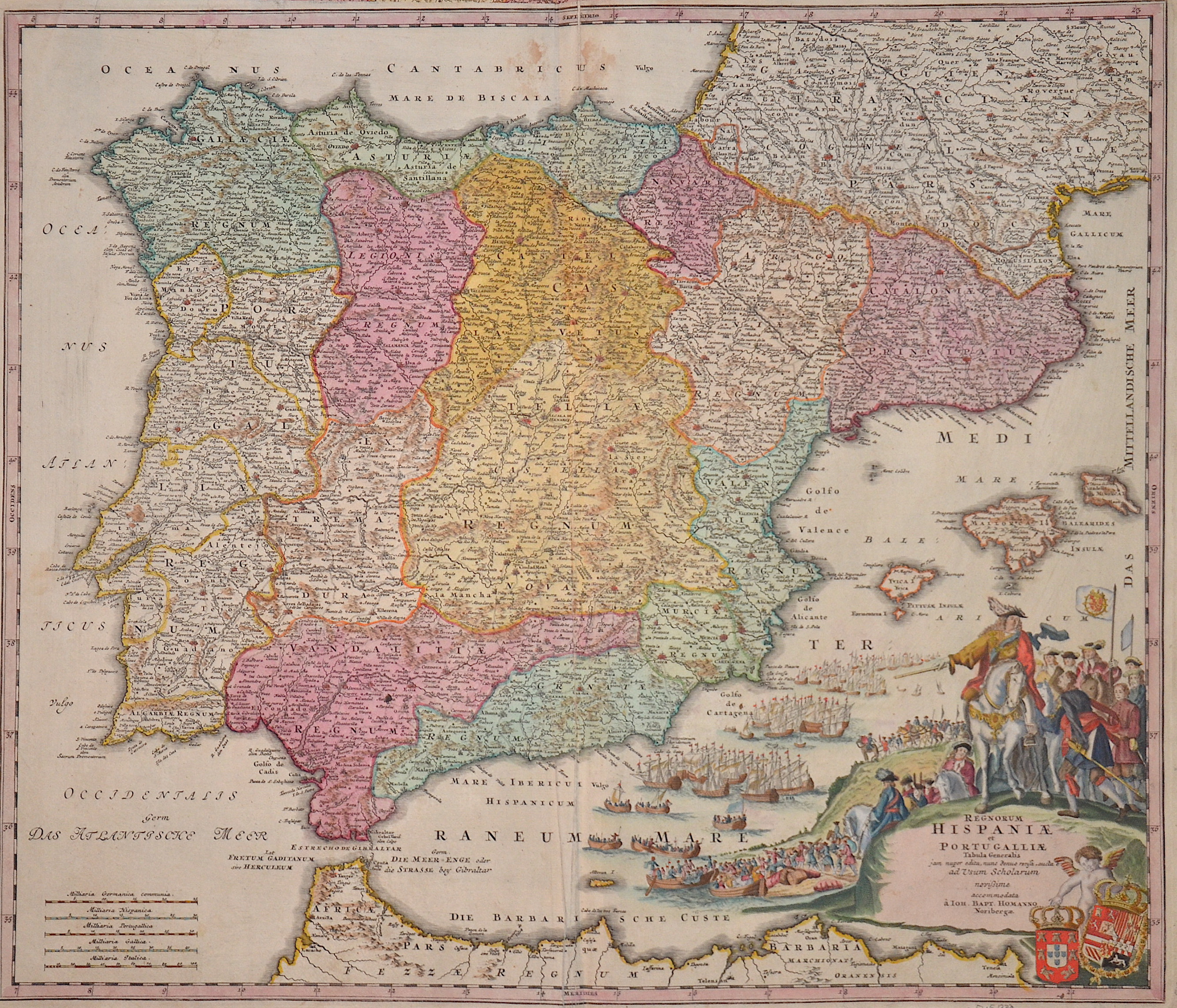
Regnorum Hispaniae et Portugalliae tabula generalis…

| Article ID | EUE1377 |
Title | Regnorum Hispaniae et Portugalliae tabula generalis… |
Description | Decorative map showing the Iberian Peninsula with Spain, Portugal and the Balearic Islands. Splendid title cartouche with many allegorical scenes, showing the Spanish Armada at sea, the success of the Spanish conquests all over the world. Furthermore, a putto holds the Portuguese coat of arms and the Spanish Habsburg coat of arms. |
| Year | ca. 1710 |
Artist | Homann (1664-1724) |
Johann Babtiste Homann (1664-1724), Nuremberg, was born in Oberkammlach, the Electorate of Bavaria. Although educated at a Jesuit school, and preparing for an ecclesiastical career, he eventually converted to Protestantism and from 1687 worked as a civil law notary in Nuremberg. He soon turned to engraving and cartography; in 1702 he founded his own publishing house. Homann acquired renown as a leading German cartographer, and in 1715 was appointed Imperial Geographer by Emperor Charles VI. Giving such privileges to individuals was an added right that the Holy Roman Emperor enjoyed. In the same year he was also named a member of the Prussian Academy of Sciences in Berlin. Of particular significance to cartography were the imperial printing privileges (Latin: privilegia impressoria). These protected for a time the authors in all scientific fields such as printers, copper engravers, map makers and publishers. They were also very important as a recommendation for potential customers. In 1716 Homann published his masterpiece Grosser Atlas ueber die ganze Welt (Grand Atlas of all the World). Numerous maps were drawn up in cooperation with the engraver Christoph Weigel the Elder, who also published Siebmachers Wappenbuch. Homann died in Nuremberg. He was succeeded by the Homann heirs company, which was in business until 1848. The company was known as Homann Erben, Homanniani Heredes, or Heritiers de Homann abroad. | |
Historical Description | In prehistoric and prehistoric times, Iberians, Celts and Basques settled on the Iberian peninsula named after the former. In the 11th century BC The Phoenicians settled on the south coast; the most famous of their colonies was Cadiz. The name Spain is derived from the Roman name Hispania (from Phoenician ishapan "land of the rock hyrax". In the early 8th century, the Moors destroyed the Visigoth Empire and conquered the entire Iberian Peninsula. Their centuries of rule shaped the country. The Arabic heritage was reflected in both the architecture and the language. However, the Moors were unable to establish themselves permanently in the northern outskirts of the peninsula. From there the "Reconquest" (Reconquista) started. In this process, which spanned several centuries (722–1492) and was not continuous, the Muslim empires were gradually pushed back by the Christian empires until the fall of Granada in 1492, the last Moorish state structure on the peninsula also disappeared. In the 15th century, the kingdoms of Castile and Aragon were united. Aragon was an important maritime power in the Mediterranean at that time. The Spanish colonial empire extended around 1600 across large parts of South and Central America, the southern part of today's USA and the Philippines. As the English and French also intensified their colonial efforts, Spain gradually lost its supremacy. The liberation wars of the American states, particularly the Mexican and South American wars of independence in the early 19th century, brought independence to most of the colonies. In 1898, the last major properties were lost to the United States during the Spanish-American War, which meant the end of the colonial empire. The African colonies that followed later (Spanish-Morocco, Spanish-Sahara and Equatorial Guinea) finally became independent in the 20th century. |
| Place of Publication | Nuremberg |
| Dimensions (cm) | 48,5 x 56 cm |
| Condition | Some restoration at lower centerfold |
| Coloring | original colored |
| Technique | Copper print |