

Adina Sommer
Antique and Contemporary Art
Winzerer Str. 154
80797 München
telephone
+49 89 304714
business hours:
by appointment
Email
![]()


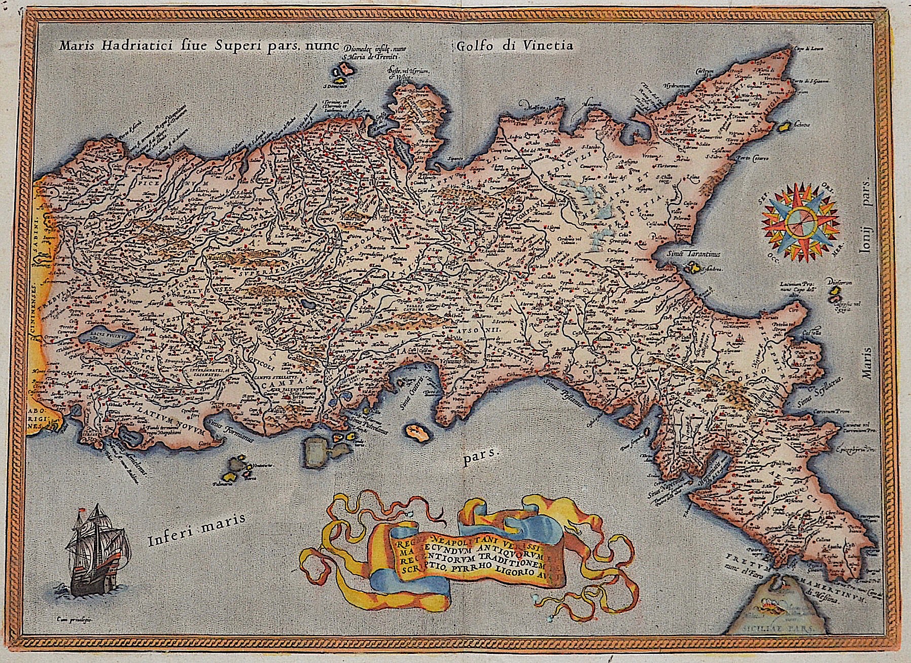
Regni Neaploitani … Descriptio

| Article ID | EUI400 |
Title | Regni Neaploitani … Descriptio |
Description | Map of the Kingdom of Naples / Southern Italy with a compass rose, a sailing ship and a title loop. |
| Year | ca. 1585 |
Artist | Ortelius (1527-1598) |
Abraham Ortelius (1527–1598) was a Flemish cartographer and publisher from Antwerp. Originally a map colorist, he became a major figure in cartography through his Theatrum Orbis Terrarum (1570), considered the first modern atlas—a uniform collection of reliable maps in book form. Influenced by Gerardus Mercator, Ortelius published several maps before compiling the Theatrum, which clearly showed America as a separate continent. The work was published in 42 editions and 7 languages by 1612. Unlike many of his peers, Ortelius cited his sources, and his atlas became a milestone in mapmaking and geographic knowledge. | |
Historical Description | Southern Italy consists of today's Italian regions that belonged to the Kingdom of Sicily before the unification of Italy in 1861. These are the regions of Abruzzo, Molise, Campania, Basilicata, Apulia, Calabria and Sicily. The Romans used to call the area of Sicily and coastal Southern Italy Magna Graecia ("Great Greece"), since it was so densely inhabited by the Greeks; the ancient geographers differed on whether the term included Sicily or merely Apulia and Calabria—Strabo being the most prominent advocate of the wider definitions. With this colonisation, Greek culture was exported to Italy, in its dialects of the Ancient Greek language, its religious rites and its traditions of the independent polis. An original Hellenic civilization soon developed, later interacting with the native Italic and Latin civilisations. The most important cultural transplant was the Chalcidean/Cumaean variety of the Greek alphabet, which was adopted by the Etruscans; the Old Italic alphabet subsequently evolved into the Latin alphabet, which became the most widely used alphabet in the world. In 1442 Alfonso V conquered the Kingdom of Naples and united Sicily and Naples as dependencies of the Crown of Aragon. When he died in 1458, the kingdom was again separated and Naples was inherited by Ferrante, Alfonso's illegitimate son. When Ferrante died in 1494, Charles VIII invaded Italy from France and used Angevin's claim to the throne of Naples, inherited by his father in 1481 after the death of King René's nephew, as an excuse to start the Italian wars. A point of contention between France and Spain for the next several decades, but French efforts to gain control of it weakened over the decades and Spanish control was never really compromised. The French finally gave up their claims to the kingdom through the Treaty of Cateau-Cambrésis in 1559. With the Treaty of London (1557) the new client state of the so-called Presidi ("State of Garrisons") was founded and directly ruled by Spain as part of the Kingdom of Naples. After the War of the Spanish Succession in the early 18th century, possession of the kingdom again changed hands. Under the terms of the Treaty of Utrecht in 1713, Naples was given to Charles VI, the Holy Roman Emperor. |
| Place of Publication | Antwerp |
| Dimensions (cm) | 37 x 50 cm |
| Condition | Very good |
| Coloring | colored |
| Technique | Copper print |