

Adina Sommer
Antique and Contemporary Art
Winzerer Str. 154
80797 München
telephone
+49 89 304714
business hours:
by appointment
Email
![]()


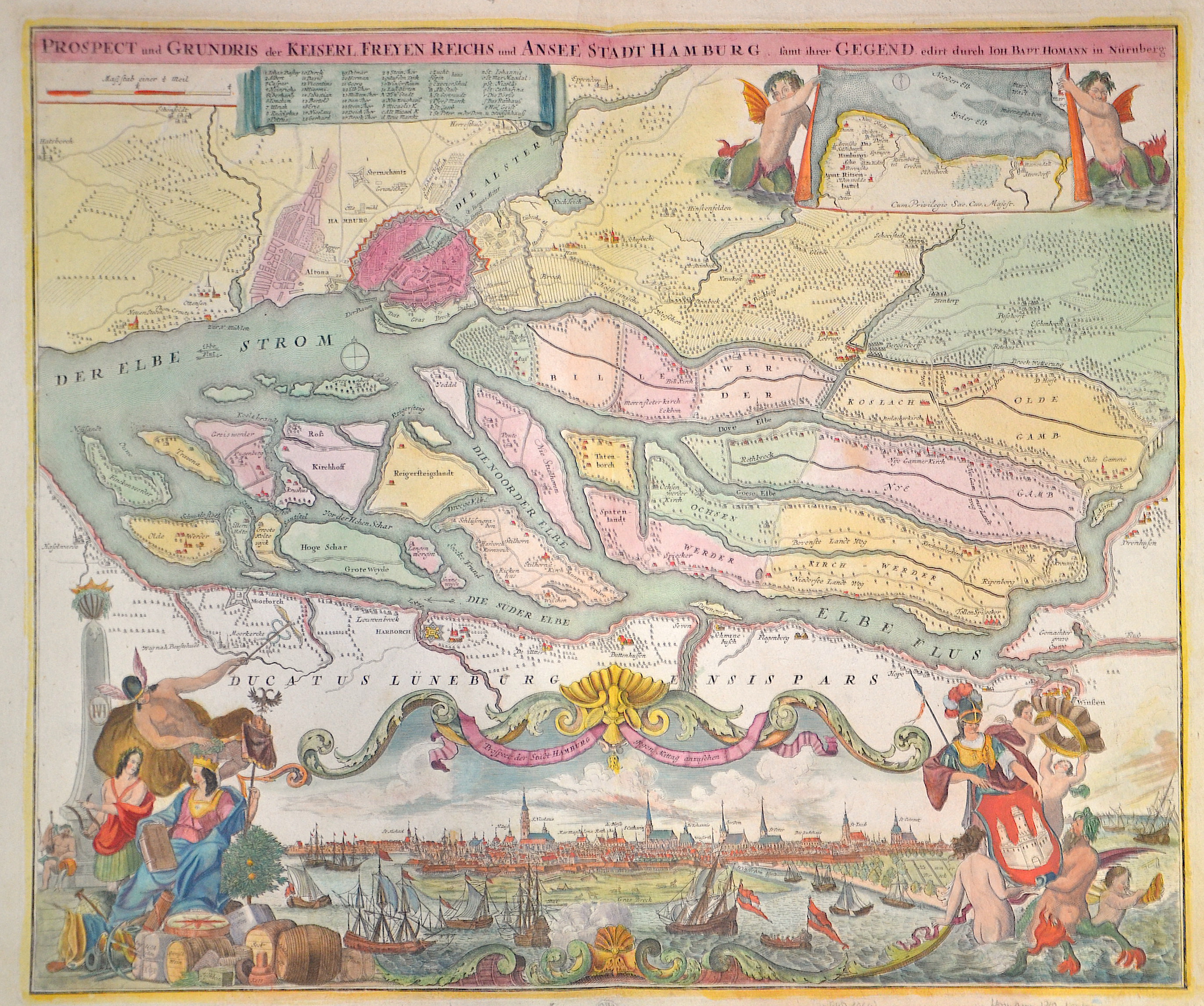
Prospect und Grundris der Kaiserl. Freyen Reichs und Ansee Stadt Hamburg sammt ihrer Gegend

| Article ID | EUD1064 |
Title | Prospect und Grundris der Kaiserl. Freyen Reichs und Ansee Stadt Hamburg sammt ihrer Gegend |
Description | Map shows the urban area with a city map of Hamburg and a beautyfull total view of the city, 2 beautyfull cartouches showing allegorical the trsde and the arms of the city, on seperate map showing the hamburgian Amt Ritzenbuttel. |
| Year | ca. 1710 |
Artist | Homann (1664-1724) |
Johann Babtiste Homann (1664-1724), Nuremberg, was born in Oberkammlach, the Electorate of Bavaria. Although educated at a Jesuit school, and preparing for an ecclesiastical career, he eventually converted to Protestantism and from 1687 worked as a civil law notary in Nuremberg. He soon turned to engraving and cartography; in 1702 he founded his own publishing house. Homann acquired renown as a leading German cartographer, and in 1715 was appointed Imperial Geographer by Emperor Charles VI. Giving such privileges to individuals was an added right that the Holy Roman Emperor enjoyed. In the same year he was also named a member of the Prussian Academy of Sciences in Berlin. Of particular significance to cartography were the imperial printing privileges (Latin: privilegia impressoria). These protected for a time the authors in all scientific fields such as printers, copper engravers, map makers and publishers. They were also very important as a recommendation for potential customers. In 1716 Homann published his masterpiece Grosser Atlas ueber die ganze Welt (Grand Atlas of all the World). Numerous maps were drawn up in cooperation with the engraver Christoph Weigel the Elder, who also published Siebmachers Wappenbuch. Homann died in Nuremberg. He was succeeded by the Homann heirs company, which was in business until 1848. The company was known as Homann Erben, Homanniani Heredes, or Heritiers de Homann abroad. | |
Historical Description | Graf Adolf III. von Schauenburg und Holstein war im 12. Jahrhundert der Gründer einer Handels- und Marktsiedlung am westlichen Alsterufer. It rose on rocky terrain in a marsh between the River Alster and the River Elbe as a defence against Slavic incursion, and acquired the name Hammaburg, burg meaning castle or fort. In 1189, by imperial charter, Frederick I "Barbarossa" granted Hamburg the status of a Free Imperial City and tax-free access (or free-trade zone) up the Lower Elbe into the North Sea. In 1265, an allegedly forged letter was presented to or by the Rath of Hamburg. In 1529, the city embraced Lutheranism, and it received Reformed refugees from the Netherlands and France. When Jan van Valckenborgh introduced a second layer to the fortifications to protect against the Thirty Years War in the seventeenth century, he extended Hamburg and created a "New Town" (Neustadt) whose street names still date from the grid system of roads he introduced. Upon the dissolution of the Holy Roman Empire in 1806, the Free Imperial City of Hamburg was not incorporated into a larger administrative area while retaining special privileges (mediatised), but became a sovereign state with the official title of the Free and Hanseatic City of Hamburg. Hamburg was briefly annexed by Napoleon I to the First French Empire (1804–1814/1815). Russian forces under General Bennigsen finally freed the city in 1814. Hamburg re-assumed its pre-1811 status as a city-state in 1814. The Vienna Congress of 1815 confirmed Hamburg's independence and it became one of 39 sovereign states of the German Confederation (1815–1866). |
| Place of Publication | Nuremberg |
| Dimensions (cm) | 49 x 58 cm |
| Condition | Very good |
| Coloring | original colored |
| Technique | Copper print |