

Adina Sommer
Antique and Contemporary Art
Winzerer Str. 154
80797 München
telephone
+49 89 304714
business hours:
by appointment
Email
![]()


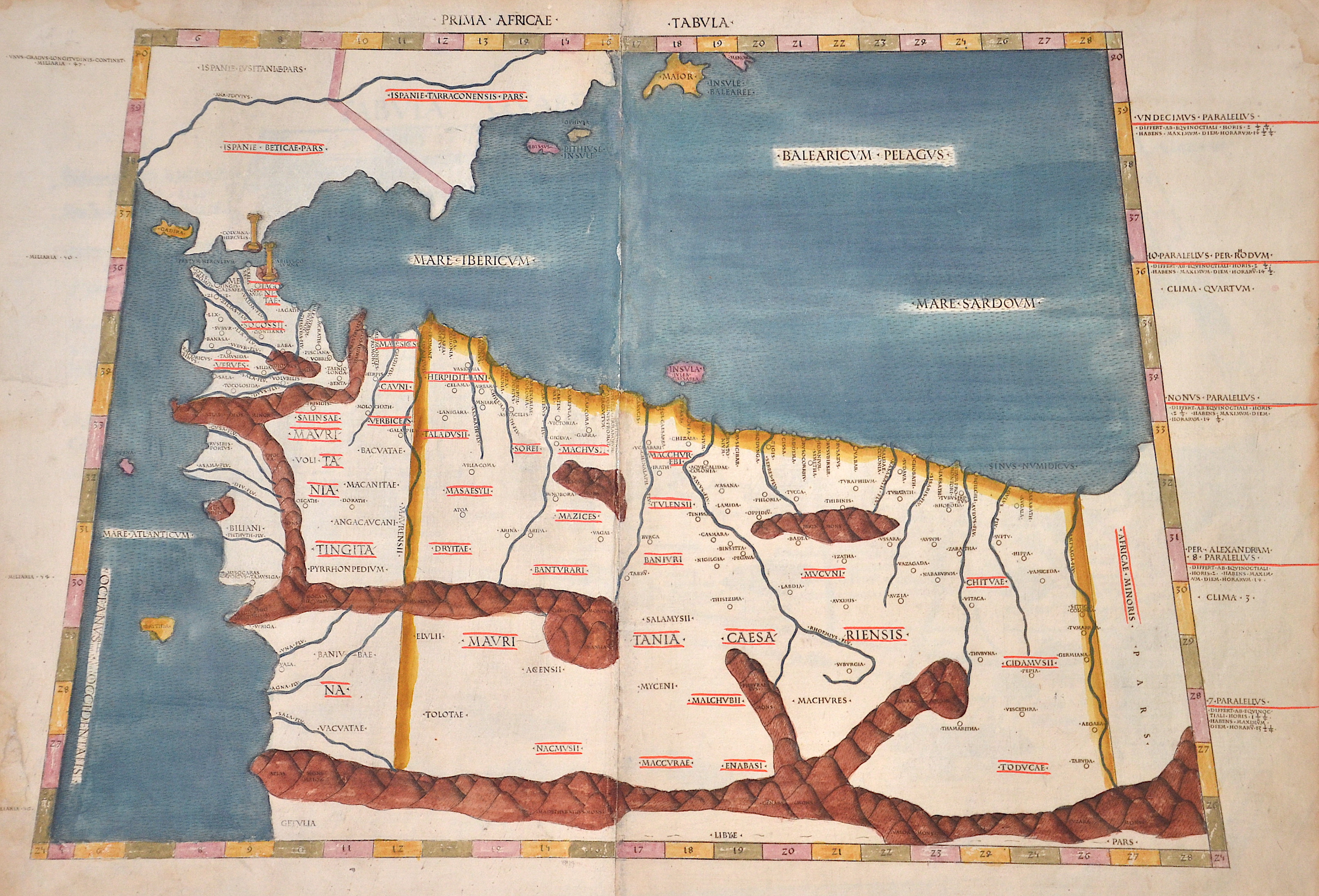
Prima Africae Tabula

| Article ID | AF0273 |
Title | Prima Africae Tabula |
Description | Map shows trapezoid northwest Africa, Algeria, Arocco and Mauretania. Rivers and mountains are roughly shown in the country on the side the climatically zones. Ptolomey watermark on the right side. |
| Year | ca. 1490 |
Artist | Ptolemy/Conrad Sweynheym |
Arnold Pannartz and Konrad Sweinheim were two printers of the 15th century. Pannartz died about 1476, Sweinheim in 1477. Pannartz was, perhaps, a native of Prague, and Sweinheim of Eltville near Mainz. Zedler believes (Gutenberg-Forschungen, 1901) that Sweinheim worked at Eltville with Gutenberg in 1461-1464. Whether Pannartz had been connected with Sweinheim in Germany is not known. It is certain that the two brought Gutenberg's invention to Italy. The Benedictine abbey of Subiaco was the cradle of Italian printing. Probably Cardinal Giovanni of Turrecremata, who was Abbot in commendam of Subiaco, summoned the two printers there. They came in 1464. The first book that they printed at Subiaco was a Donatus; it has not, however, been preserved. The first book printed in Italy that is extant was a Cicero, De oratore (now in the Buchgewerbehaus at Leipzig), issued in September, 1465. It was followed by Lactantius, De divinis institutionibus, in October, 1465, and Augustine's De civitate Dei (1467). These four impressions from Subiaco are of particular importance, because they abandon the Blackletter of the early German books. In Italy, Roman characters were demanded. Pannartz and Sweinheim, however, did not produce a pure but only a ""half Roman"" type with Blackletter-like characteristics. n 1467, the two printers left Subiaco and settled at Rome, where the brothers Pietro and Francesco Massimo placed a house at their disposal. The same year, they published an edition of Cicero's letters that gave its name to the cicero, the Continental equivalent of the pica. Their proof and manuscript reader was Giovan de' Bussi, since 1469 Bishop of Aleria in Corsica. In 1472, they applied to Pope Sixtus IV for Church benefices. From this we know that both were ecclesiastics: Pannartz of Cologne and Sweinheim of Mainz. The pope had a reversion drawn up for them, a proof of his great interest in printing. In 1474, Sweinheim was made a canon at St. Victor at Mainz. It is not known whether Pannartz also obtained benefice. Perhaps the pope also aided them, at any rate, they printed eighteen more works in 1472 and 1473. After this they separated. Pannartz printed by himself thirteen further volumes. Sweinheim took up engraving on metal and executed the fine maps for the Cosmography of Ptolemy (arround 100- 160 a.C.), the first work of this kind, but died before he had finished his task. Claudius Ptolemy Geographia, gives a list of geographic coordinates of spherical longitude and latitude of almost ten thousand point locations on the earth surface, as they were known at his times. The list is organized in Tabulae which cor- respond to specific regions of the three known continents at that time, Africa, Asia and Europe. Research on Ptolemy’s Geographia has started at the University of Thessaloniki, Greece, in the eighties, focused mainly, but not exclusively, on data re- lated to territories which are now under the sovereignty of the modern Greek state. The World of Ptolemy is classified in Regions, since each Chapter is referred to one of them, giving by this way the concept of Atlas as it is understood today. | |
Historical Description | North Africa in the broader geographical sense is the area of the continent of Africa that includes the Sahara and the coastal strip to the north, west and east of the Mediterranean, the Atlantic and the Red Sea. Religiously, North Africa is mainly characterized by Islam, ethnically by Berbers, Moors and Arabs, in the southernmost area also Nubians, Amhars and Black Africans. The core states of North Africa include Morocco with the Western Sahara, Algeria, Tunisia (small Maghreb), Libya (Greater Maghreb), Egypt and Sudan. Especially during the ongoing desert phase, contacts between North and sub-Saharan Africa were therefore limited almost exclusively to trade along the east and west coasts of the continent and to certain routes where there were sufficient water points, due to the difficulties of crossing the world's largest sandy desert. At the same time, this meant ethnic separation, and although North African culture has both African and Middle Eastern roots, with the Berbers possibly even European. With antiquity in the narrower sense, the interests of the Mediterranean peoples, which had previously been focused primarily on Egypt and the Near East in terms of power politics, gradually changed. As so often in history, it was trade that paved new paths; and the first people to devote themselves entirely to Mediterranean trade, even to the neglect of their own state structures, were the Phoenicians, but the place in North Africa where territorial state structures did develop, at least to some extent, was Carthage. In the period between the destruction of Carthage and Rome taking control of the Maghreb, there was a brief flourishing of local kingdoms. Two largely sedentary ethnic groups, the Moors and Numidians, were of particular importance. After the victory over Carthage, Roman culture and, above all, Roman administration spread relatively quickly from east to west along the Atlas mountain ranges across the new territories in North Africa. The North African provinces quickly became economically central to the Roman Empire, and between the 1st and 4th centuries AD, Rome's survival actually depended on grain and olive supplies from there, as the climate in North Africa at that time was wetter than it is today. When the Romans took power in the Mediterranean, a development came to an end in the course of which North Africa in particular finally became part of the Mediterranean world. |
| Place of Publication | Rome |
| Dimensions (cm) | 34 x 53 cm |
| Condition | Tear on the left side perfectly restored, printed on two sheets and joined together |
| Coloring | original colored |
| Technique | Woodcut |