

- Alsace
- Aquitaine
- Auvergne
- Bourgogne
- Bourgogne-Franche-Comte
- Brittany
- Centre
- Champagne
- Flandre
- France Islands
- Gascogne
- Gironde
- Hauts-de-France
- Ile de France
- Languedoc
- Lothringen
- Midi-Pyrénées
- Nivernais
- Nord-Pas-de-Calais
- Normandie
- Occitanie
- Paris
- Pas-de-Calais
- Pays de la Loire
- Picardie
- Poitou-Charentes
- Provence-Alpes-Cote d Azur
- Pyrénées
- Rhone- Alpes
- Saintonge
- Savoyen
- Tourain
- Westcoast
Adina Sommer
Antique and Contemporary Art
Winzerer Str. 154
80797 München
telephone
+49 89 304714
business hours:
by appointment
Email
![]()


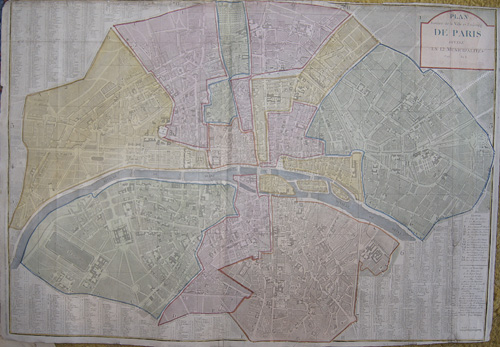
Plan routier de la ville et Fanbourg de paris divise en 12 municipaites 1799 Au 8
| Article ID | EUF2799 |
Title | Plan routier de la ville et Fanbourg de paris divise en 12 municipaites 1799 Au 8 |
Map shows a citymap of Paris with its 12 quaters | |
| Year | dated 1799 |
Artist | Dezauche |
| Place of Publication | Paris |
| Dimensions (cm) | 56 x 80 |
| Condition | Some folds perfectly restored |
| Coloring | original colored |
| Technique | Copper print |
:
75.00 €
( A reproduction can be ordered individually on request. )