

- Alsace
- Aquitaine
- Auvergne
- Bourgogne
- Bourgogne-Franche-Comte
- Brittany
- Centre
- Champagne
- France Islands
- Gascogne
- Gironde
- Hauts-de-France
- Ile de France
- Languedoc
- Lothringen
- Midi-Pyrénées
- Nivernais
- Nord-Pas-de-Calais
- Normandie
- Occitanie
- Pas-de-Calais
- Pays de la Loire
- Picardie
- Poitou-Charentes
- Provence-Alpes-Cote d Azur
- Pyrénées
- Rhone- Alpes
- Saintonge
- Savoyen
- Tourain
- Westcoast
Adina Sommer
Antique and Contemporary Art
Winzerer Str. 154
80797 München
telephone
+49 89 304714
business hours:
by appointment
Email
![]()


Plan of the fort de Medoc with the citadel and battery of Blaye.
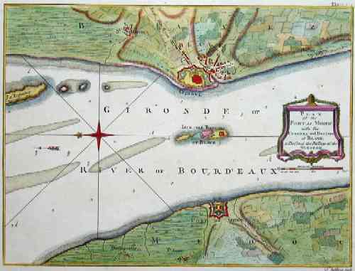

| Article ID | EUF1828 |
Title | Plan of the fort de Medoc with the citadel and battery of Blaye. |
Description | Map shows the city of Baye and Fort Medoc and the Citadel of Sébastien Le Prestre, Seigneur de Vauban. |
| Year | ca. 1780 |
Artist | Jefferys (1719-1771) |
Thomas Jefferys "Geographer to King George III", was an English cartographer who was the leading map supplier of his day. He engraved and printed maps for government and other official bodies and produced a wide range of commercial maps and atlases, especially of North America | |
| Place of Publication | London |
| Dimensions (cm) | 18,5 x 25 cm |
| Condition | Perfect condition |
| Coloring | colored |
| Technique | Copper print |