

Adina Sommer
Antique and Contemporary Art
Winzerer Str. 154
80797 München
telephone
+49 89 304714
business hours:
by appointment
Email
![]()


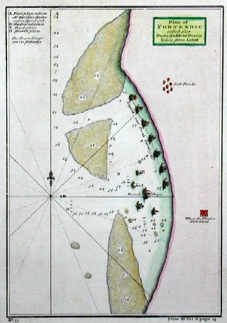
Plan of Portendic called also Portu d´addi or Penia Taken from Labat

| Article ID | AF0127 |
Title | Plan of Portendic called also Portu d´addi or Penia Taken from Labat |
Description | Map shows part of the coast off Senegal, the salt ponds near Saint-Louis, offshore sailing ships, compass rose and an index. In the 16th and 18th centuries, Portendic was a French harbour, founded by the French East India Company and dependent on the colony of Senegal. It was located thirty kilometres north of Saint-Louis and was important for the trade in gum arabic; it was a trading post of the French East India Company. from ‘A new general collection of voyages and travels: consisting of the most esteemed relations, which have been hitherto published in any language; comprehending everything remarkable in its kind, in Europe, Asia, Africa, and America’. |
| Year | c. 1745 |
Artist | Gardiners |
Historical Description | Until colonization, the southern part of Côte d'Ivoire had no state formation. The northern part, on the other hand, came under the influence of the Sahel empires from the 11th century onward, such as the Mali empire from the 13th century onward. At the same time, Islam came to this region through trade and warfare. In the 17th century, the city-state of Kong was the most powerful state in the region and a center of Islamic scholarship. The Portuguese traded with the coastal tribes from the 15th century, but were displaced by the French from the 17th century, who established the Grand-Bassam naval base in 1843 and declared the area a French colony of Côte d'Ivoire in 1893. The suppression of rebellions, especially those of the Islamic leader Samory Touré, kept the French colonial administration busy for several years. In 1895, Côte d'Ivoire became part of French West Africa, where the Code de l'indigénat also applied. In 1956 it received internal self-government. The state of Côte d'Ivoire is the result of colonial demarcations that did not take into account pre-existing geographical or natural boundaries or religious, linguistic or cultural units. The national territory therefore unites regions that had no common history prior to this border demarcation. Other peoples, on the other hand, are separated by the state border from regions outside the present state with which they share a common history. |
| Place of Publication | London |
| Dimensions (cm) | 21,5 x 15 cm |
| Condition | Perfect condition |
| Coloring | original colored |
| Technique | Copper print |